Appendix A: Other Boston Region Transportation Planning Studies
Appendix B: Public Engagement and Public Comments
Appendix C: Universe of Program Feedback and Proposed Discrete Studies for Federal Fiscal Year 2026 UPWP
Appendix D: Geographic Distribution of UPWP Studies and Technical Analyses
Appendix E: Regulatory and Policy Framework
Appendix F: Boston Region Metropolitan Planning Organization Membership
This appendix outlines transportation studies and technical analyses to be conducted in the Boston Region Metropolitan Planning Organization (MPO) area during federal fiscal year (FFY) 2026. These efforts will be funded through sources outside the MPO’s core planning funds. The appendix is organized into two sections:
This section provides brief descriptions of planning studies that MPO staff will conduct with funding from MassDOT-directed Section 5303 Federal Transit Administration, partner agencies, and grant programs.
Table A-1
Unified Planning Work Program Budget—New and Continuing Agency Transportation Planning Studies and Technical Analyses for FFY 2026
| Name | Funding Source | Total Contract | FFY 2026 Proposed Agency Funds (Salary and Overhead) | Direct Costs | Total FFY 2026 Proposed Budget |
| MassDOT 5303-Directed Funds | MassDOT 3C PL | $357,896 | $357,896 | $0 | $357,896 |
| MassDOT SPR Program Support | SPR | $440,000 | $440,000 | $0 | $440,000 |
| MassDOT Title VI Program | MassDOT | $95,000 | $4,800 | $0 | $4,800 |
| I-90 Allston Multimodal Modeling | MassDOT | $400,000 | $5,000 | $0 | $5,000 |
| MassDOT Projects | blank | $1,292,896 | $807,696 | $0 | $807,696 |
| MBTA SFY 2025 National Transit Database (NTD) Support | MBTA | $234,184 | $223,178 | $300 | $223,178 |
| MBTA Triennial Title VI Program | MBTA | $125,750 | $107,992 | $0 | $107,992 |
| MBTA Transit Service Data Collection | MBTA | $1,130,000 | $198,000 | $0 | $198,000 |
| MBTA Rider Oversight Committee Support | MBTA | $31,342 | $15,000 | $0 | $15,000 |
| MBTA Bus Shelter Maps | MBTA | $21,183 | $10,500 | $0 | $10,500 |
| MBTA Mapping Support | MBTA | $18,000 | $6,000 | $0 | $6,000 |
| Map and Signage Support to the MBTA Bus Network Redesign Phase 2 | MBTA | $93,204 | $20,301 | $0 | $20,301 |
| MBTA Projects | blank | $1,653,663 | $580,971 | $0 | $580,971 |
| Municipal Vulnerability Preparedness (MVP) Action Grant Program - NO-HEAT Project | Executive Office of Energy and Environmental Affairs | $1,001,100 | $150,000 | $300,000 | $450,000 |
| Grant-Funded Regional Transportation Planning Studies | blank | $1,001,100 | $150,000 | $300,000 | $450,000 |
| Agency-Funded and Client-Funded Subtotal | blank | $3,947,659 | $1,538,667 | $300,000 | $1,838,667 |
Funding Source |
MassDOT-Direct PL |
Total Contract Amount |
$357,896 |
FFY 2026 Total Budget |
$357,896 |
Under the US Code of Federal Regulations, Title 49, Section 5303, MPOs and departments of transportation are provided 3C planning (PL) funds to carry out transit projects. The Boston Region MPO’s 5303 FTA funds are administered by MassDOT, distributed to the MPO based on an allocation formula, and require a state match.
MPO staff will provide transit-planning assistance within the region by conducting various studies under the MassDOT-directed PL program. Individual projects and tasks will be executed throughout FFY 2026 to support transit-related research, planning, data collection, and analysis.
The contracts and technical analyses in this section are being undertaken for MassDOT.
Funding Source |
MassDOT SPR |
Total Contract Amount |
$440,000 |
FFY 2026 Total Budget |
$440,000 |
As requested, MPO staff will conduct studies and analyses and provide technical assistance through MassDOT’s SPR program. These contracts will include multiple individual projects or tasks throughout the federal fiscal year.
Two projects that are either underway or expected to begin in FFY 2026 are the Roadway Inventory and Related Support Maintenance and the Statewide Model Assistance Project. Other projects may be added throughout FFY 2026.
Funding Source |
MassDOT Other |
Total Contract Amount |
$95,000 |
FFY 2026 Total Budget |
$4,800 |
MassDOT, as a recipient of federal funds from both the Federal Highway Administration (FHWA) and the FTA, is required to comply with Title VI of the Civil Rights Act of 1964, and with protections enacted through several other laws and executive orders that prohibit discrimination based on race, color, national origin, disability, age, sex, and other protected characteristics.
Under this contract, MPO staff will continue to provide technical support to MassDOT for developing and implementing its Title VI Program for both the FHWA and the FTA.
Funding Source |
MassDOT |
Total Contract |
$400,000 |
FFY 2026 Total Budget |
$5,000 |
MassDOT is currently developing a Supplemental Draft Environmental Impact Report for the Allston Multimodal project, and MPO staff will produce travel-demand forecasts in support of this environmental filing in FFY 2026. As part of this contract, MPO staff will use the regional travel demand model to estimate highway volumes, transit volumes, and mode splits for horizon-year (2050) scenarios of the Allston Multimodal project.
The contracts and technical analyses in this section are being undertaken for the MBTA.
Funding Source |
MBTA |
Total Contract* |
$234,184 |
FFY 2026 Total Budget |
$223,178 |
*State Fiscal Year 2025 contract; contracts for subsequent State Fiscal Years are forthcoming
In support of the MBTA’s NTD submittals to the FTA, MPO staff have continued to produce passenger-miles traveled and unlinked trip estimates for MBTA services. Through this contract, MPO staff will develop these estimates for the following modes:
MPO staff will use the following methods to collect the data on which these estimates will be based:
The MBTA will submit its State Fiscal Year (SFY) 2025 NTD passenger-miles traveled and unlinked trip estimates for various transit modes to the FTA during FFY 2026. The final technical memoranda for SFY 2026 NTD will be completed in FFY 2027.
In FFY 2026, MPO staff will complete the final technical memoranda and auditing process for SFY 2025 NTD reporting and will complete data collection begun in FFY 2025 for SFY 2026. Field staff will begin collecting data for SFY 2027 NTD reporting.
Funding Source |
MBTA |
Total Contract |
$125,750 |
FFY 2026 Total Budget |
$107,992 |
MPO staff will collect and analyze transit service data to contribute to a triennial Title VI program for the MBTA. This work supports the MBTA’s compliance with Title VI requirements.
Staff will collect and analyze data on the following service indicators:
The data-collection and analysis activities will help to fulfill monitoring required of the MBTA under Title VI. These analysis results will be incorporated into the MBTA’s 2026 Triennial Title VI program, which MPO staff will produce for submission to the FTA. The triennial program will include the service and fare change analyses that were conducted for the MBTA in the preceding three years, demographic and service profile maps and charts, and additional documentation to meet the MBTA’s general reporting requirements.
Funding Source |
MBTA |
Total Contract |
$1,130,000 |
FFY 2026 Total Budget |
$198,000 |
The work conducted under this contract will help the MBTA to assess bus and rapid transit service changes. The MBTA requires ongoing data collection regarding its transit system to assess service changes, and as part of this project, MPO staff will collect ridership and performance data to support future MBTA service changes. Work may also include support for improving the ridecheck database so that it is compatible with new software and data sources. MPO staff also may provide analytical assistance to the MBTA as requested.
Funding Source |
MBTA |
Total Contract |
$31,342 |
FFY 2026 Total Budget |
$15,000 |
The MBTA established a Rider Oversight Committee (ROC) in 2004 to provide ongoing public input on a number of different issues, including strategies for increasing ridership, developing new fare structures, and prioritizing capital improvements. Through this contract, MPO staff will support the MBTA by providing ongoing technical assistance to the ROC.
Assistance provided by MPO staff has included offering insights into the MBTA’s planning processes, providing data analysis, and attending committee meetings, at which staff may respond directly to ROC members’ questions.
Funding Source |
MBTA |
Total Contract |
$21,183 |
FFY 2026 Total Budget |
$10,500 |
Upon request from the MBTA, MPO staff will create new bus shelter maps using the MBTA System Map (an MPO product) as a source. At the time of each request, MPO staff will provide the MBTA with an estimate of the specific cost and schedule for completing the map(s).
Funding Source |
MBTA |
Total Contract |
$18,000 |
FFY 2026 Total Budget |
$6,000 |
Upon request from the MBTA, MPO staff will update MBTA maps to reflect changes. MPO staff will also update other existing MPO-created MBTA maps within the budget provided for this project. At the time of each request, MPO staff will provide the MBTA with an estimate of the specific cost and schedule for completing the map(s).
Funding Source |
MBTA |
Total Contract |
$93,204 |
FFY 2026 Total Budget |
$20,301 |
MPO staff will update rapid transit system, bus, and neighborhood maps to reflect changes to bus routes in accordance with the MBTA Bus Network Redesign. Upon request from the MBTA, MPO staff will update other existing MPO staff-created MBTA maps within the budget provided for this project.
This section provides brief descriptions of planning studies that MPO staff will conduct with funding from grant programs.
Funding Source |
Executive Office of Energy and Environmental Affairs |
Total Contract |
$1,001,100 |
FFY 2026 Total Budget |
$450,000 |
In 2024, the Boston Region MPO was awarded an MVP Action Grant from the Executive Office of Energy and Environmental Affairs for the Commonwealth of Massachusetts. The grant will support the MPO's project titled “Neutralizing Onerous Heat Effects on Active Transportation” (NO-HEAT), which aims to address dangerous heat exposure faced by people in Boston-area communities who walk and bike.
The NO-HEAT project will integrate urban microclimate data with high-resolution mobility data to assess heat exposure levels for individuals walking or biking across the Boston region. The project will focus on identifying high-risk communities and prioritizing key pedestrian and bike network segments most vulnerable to heat stress. In collaboration with local partners, MPO staff will plan, design, and implement pilot mitigation measures, such as urban greenery, reflective paint, and shaded shelters, to reduce heat exposure at selected high-risk locations.
This section consists of brief descriptions of planning studies that will be conducted in the Boston Region MPO area by other agencies, such as MassDOT and the MBTA, during FFY 2026. The studies listed in this section are either supported by federal planning (but not MPO) funds, and/or have been determined to be of regional significance by MPO staff and partner agencies. The project listings are organized hierarchically: first by type of study, then by geography, then by the entity organizing or leading the study effort.
The projects in this section are not subject to the MPO’s public participation process; rather, they follow their own public processes. They are included here to provide a more complete picture of the surface-transportation-planning projects occurring in the region. The listings contained in this section were provided to MPO staff prior to July 1, 2025.
Municipalities that received SS4A grants in the Boston region are listed below. More information about each of these awards can be found by following the accompanying links.
Beyond Mobility, the Massachusetts 2050 Long-Range Transportation Plan, is a planning process that will result in a blueprint for guiding transportation decision-making and investments in Massachusetts in a way that advances MassDOT’s goals and maximizes the resiliency of the transportation system. The Plan will serve as a strategic plan for MassDOT and document the most pressing transportation priorities for MassDOT to address between now and 2050, relying heavily on input from the public.
The project team, considering what the world will be like in 2050, analyzed previous plans, public engagement responses, and results from a needs assessment and identified six key priority areas of Massachusetts to focus on over the long term. These are safety, destination connectivity, travel experience, reliability, supporting clean transportation, and resiliency. Within the Plan, vision statements, values, problem statements, and more than 100 action items have been developed and are organized by these six priority areas.
Beyond Mobility was finalized in June 2024 and the full plan and executive summary are available on the plan webpage https://www.mass.gov/beyond-mobility.
MassDOT, MAPC, and the City of Boston were awarded a $21,600,000 Congestion Relief Grant for the LINKUP project. This grant will fund the implementation of new shuttle networks in Boston’s Seaport, Charlestown, and Allston-Brighton neighborhoods. Funds will also be used to purchase new Bluebikes and electrified stations across the service area, enabling e-bikes to charge while docked.
MassDOT’s Office of Transportation Planning is conducting a study to determine long-term multimodal transportation and safety improvements to the Newton Corner I-90: Exit 127 (formerly Exit 17) Interchange in Newton, Massachusetts, bordering Brighton and Watertown.
This conceptual planning study will examine ways to improve mobility, system reliability, safety, connectivity, economic opportunity, accessibility, efficiency, and resiliency in the study area.
MassDOT’s Office of Transportation Planning is conducting a study of long-term alternatives for the replacement of the Maurice J. Tobin Memorial Bridge (Tobin Bridge). The Tobin Bridge carries US Route 1 over the Mystic River and connects Boston and Chelsea. In tangent with developing future means for Route 1 to cross the river, this study will consider opportunities to implement and improve transit priority and multimodal travel over the future bridge or its alternative and accommodate existing and future vehicle traffic levels.
United States Department of Transportation (USDOT) awarded the City of Boston, in partnership with the City of Chelsea, a $2,500,000 Reconnecting Communities Pilot (RCP) grant to plan and design a critical walking and biking connection between the Mary Ellen Welch Greenway in East Boston and the Chelsea Greenway in Chelsea. The project will evaluate alternatives, choose a preferred alignment, and advance a concept design for a shared walk and bike path that will link together the two communities.
The City of Cambridge was awarded $2,400,000 to plan and design an accessible, elevated, pedestrian and bicycle crossing of the Fitchburg Commuter rail line in North Cambridge. This grant will help the city continue planning and advancing conceptual and final design of an overpass connecting the Rindge Avenue neighborhood to Danehy Park. This in turn will work to help improve access to stores, jobs, and transit. The project also includes planning and design for a multiuse path parallel to the rail line.
The City of Everett was awarded $1,200,000 to study the feasibility of installing a transit hub at Sweetser Circle and developing safe and accessible connections between Upper Broadway, Lower Broadway, and Main Street in Everett. This planning study will consider accommodations for future Silver Line (MBTA Bus Rapid Transit) expansion, siting of a Commuter Rail stop, connections to existing bicycle facilities (Northern Strand Trail, Wellington Trail, and more), open green space, and connections between the Lower and Upper Broadway neighborhoods with new and improved pedestrian and bicycle facilities.
USDOT awarded the City of Boston a $2,000,000 RCP grant to reconstruct the section of Cummins Highway approaching Mattapan Square. The project will extend recent multimodal improvements on Cummins Highway to those planned for Blue Hill Avenue. In doing so, the project will bring together two long-separated sides of the neighborhood and make it easier for Mattapan residents to access the Neponset Greenway, Mattapan Station, the Main Streets business district, and safe facilities for walking and rolling.
The City of Revere was awarded an RCP grant of $400,000 to conduct the Walking to Wonderland Feasibility Study. The study will outline a plan to improve pedestrian and bicycle access to the new Wonderland Park Commuter Rail Station in Revere through the construction of several multiuse shared paths.
The Program for Mass Transportation (PMT) is the MBTA’s long-range strategic capital plan. It defines a 25-year vision for public transportation in eastern Massachusetts. Massachusetts General Law requires the MBTA to update the PMT every five years and to implement the policies and priorities outlined in it through the annual Capital Investment Program (CIP). MassDOT’s Office of Transportation Planning will lead the process for updating the new PMT working with the MBTA Policy and Strategic Planning team. The upcoming PMT is expected to kick off in Summer 2025 and take 18 months to complete.
MassDOT’s Office of Transportation Planning is conducting a study to examine opportunities to improve and implement transit priority and multimodal travel over the Gilmore Bridge in Boston and Cambridge, as well as explore the feasibility of building a new bridge between Charlestown and Cambridge to serve transit, walking, and biking trips.
The Gilmore Bridge Mobility Improvements Study will examine existing mobility and other travel conditions within the study area and evaluate short-, medium-, and long-term recommendations intended to address the needs of current and anticipated future travelers along the corridor, with a particular emphasis on providing dedicated bus lanes. In addition to exploring opportunities for transit priority measures and active transportation improvements on the Gilmore Bridge, the study will assess the feasibility of constructing a new bridge between Charlestown and Cambridge to serve transit, walking, and biking trips.
This study will build a regional rail demand and revenue forecasting tool to prioritize investment and address future mobility needs. The tool will provide rail demand data to help prioritize investments, including service improvements and track projects, station upgrades, first- and last-mile plans with local authorities and regional transit authorities, transit-oriented development projects, parking upgrades, and fare policy modifications. The key output would be the potential/latent demand/revenue that could be accessed by improvement or policy change. Specifically, the tool will be able to assess the impact of land use changes, new mobility options, and behavioral changes (including teleworking) on rail demand.
The Water Transportation Study will evaluate the feasibility of, and design and operate, a regional network of ferry services to, from, and between communities along the Massachusetts coast. The study will complete both the planning and design for expanded fully Americans with Disabilities Act (ADA)-accessible ferry service, as well as an engineering assessment of the infrastructure and vessels necessary for the operation of a ferry pilot program conducted for no fewer than three years and no more than five years. The study will be a comprehensive effort to examine past and current water transportation services against current and future need.
The Bus Awareness Study for Transit Non-Riders will examine the challenges of attracting non-transit and/or rail-only riders to using MBTA bus service as a modal option to meet their travel needs. This project seeks to support Bus Network Redesign, the Better Bus Project, and other MBTA efforts by identifying the barriers and challenges that preclude potential riders from choosing the bus, and recommending actions the MBTA can take to better attract and retain new riders. This project seeks to answer the question: How can the MBTA make buses a viable and competitive transportation choice for more people in the MBTA service area? The information obtained through this project will help provide direction to the MBTA on how to market and conduct public outreach to attract non-riders to consider using the MBTA bus system for their trips.
The MBTA’s The RIDE fleet of roughly 800 vehicles, both vans and sedans, provide the MBTA’s ADA paratransit service. The MBTA owns these vehicles, but contracts out the service to two providers, who either own or lease the garages and land where the vehicles are kept and maintained. The RIDE has considered what this might look like for paratransit vehicles as technology advances to enable more and more miles on a single charge. The RIDE Electric Vehicle Feasibility Modeling study explores how the environment of vehicle technology, charging technology, and infrastructure requirements maps against the MBTA’s vehicle requirements and garage realities.
In March 2023, the MBTA submitted a grant application to the Federal Transit Administration’s Areas of Persistent Poverty Program (APP). The APP Program is focused on providing funds for projects to assist areas of persistent poverty or historically disadvantaged communities. Eligible projects include things such as improvements to transit facilities, planning for low- or no-emission buses, and funding for coordinated public transit human service transportation plans. The MBTA submitted an application requesting $470,000 to design on-route battery electric bus (BEB) charging at Forest Hills and Ashmont stations. In July 2023, the MBTA received an award under the APP Program for $127,366 to design electric bus charging at Ashmont Station.
Ashmont Station is a pivotal MBTA station in terms of its mobility benefits facilitating transfers to numerous local bus routes as well as to subway and commuter rail. Ensuring BEBs operate efficiently and continuously throughout the service area is paramount to guaranteeing access to employment opportunities for new and existing riders alike. In addition, a majority of the bus ridership on routes serving the station originate from areas designated by the USDOT as Areas of Persistent Poverty and Historically Disadvantaged Communities. The funding to design on-route BEB charging at Ashmont Station is an important step in improving the reliability of bus service and decreasing the air quality impacts of diesel buses in and around the routes that serve the station. The MBTA’s full transition to BEBs relies on the design and construction of on-route BEB charging throughout the bus network.
FTA requires that any grants related to planning work (such as this one) be amended into the appropriate regional Unified Planning Work Program (UPWP). As such, this proposed UPWP amendment will add this project to the Appendix of the Boston Region MPO’s FFY 2024 UPWP. Since the study will be grant-funded, it will not impact funding for any other studies programmed in the FFY 2024 UPWP.
The MBTA was awarded an RCP grant of $2,000,000 to bring the JFK/UMass Station into a state of good repair, improve its accessibility, and enhance its environmental resiliency.
The MBTA was awarded a Railroad Crossing Elimination (RCE) grant of $4,000,000 to evaluate 52 high-risk, high-priority pedestrian and roadway grade crossings throughout the greater Boston regional rail network.
The City of Lynn was awarded $561,000 to reconnect West Lynn by relocating the River Works Station north of its current location and making it publicly accessible. This will reconnect adjacent neighborhoods with jobs, open space, and a planned USDOT Better Utilizing Investments to Leverage Development (BUILD)-funded bus priority corridor on the Lynnway. It will also provide rail connections to Boston and beyond, as well as communities to the north. Other benefits include an ADA-compliant crossing of the railroad, improved flood resiliency, and the facilitation of waterfront access and transit-oriented development at the adjacent Gear Works, among other potential sites.
The City of Salem was awarded $2,776,000 through the FFY 2024 BUILD grant program to conduct planning and design activities for a new commuter rail station in South Salem. The current preferred alternative to the station is situated between Canal Street and Jefferson Avenue.
The City of Boston is progressing with the redesign of the Rutherford Avenue corridor in Charlestown, which extends approximately 1.5 miles from the North Washington Street Bridge to Sullivan Square and provides a critical connection between Downtown Boston and Everett, Somerville, Cambridge, and suburbs to the north and east of Boston. The project will also reconfigure the street network around Sullivan Square Station to improve Orange Line access for Charlestown residents and others walking, rolling, and taking the bus.
USDOT awarded the City of Boston a $1,800,000 RCP award to plan a better, safer, greener, and more attractive connection between the two sides of the open-cut Massachusetts Turnpike (I-90) in Chinatown. The plan will bring together the two sides of Boston’s historic Chinatown that the Interstate divided in the 1960s. It will also increase greenery and safe and accessible walking routes, reduce pollution, and improve quality of life in the neighborhood.
USDOT awarded the City of Boston a $20,000 BUILD grant to plan, design, and implement improvements for three important corridors in Roxbury: Malcolm X Boulevard, Warren Street, and Melnea Cass Boulevard. The project will partner with local residents and community organizations to make getting around Roxbury safer, more convenient, and more enjoyable and improve the quality of life in the neighborhood.
This is a planning-level analysis of which transportation assets are at risk of flooding over the coming century. This study identifies flood exposure for in-state National Highway System roads, bridges, and large culverts; MassDOT- and MBTA-owned rail; MassDOT facilities; and many public-use airports. It assesses damage and repair costs, time estimates for repairs, and considers the consequences from loss of service. Specifically, this study will estimate “do nothing” costs and qualitative consequences of at-risk transportation assets under future conditions assuming no intervention. This information can be used during the capital planning process to prioritize investments that avoid or reduce long-term climatic impacts associated with flooding.
This study will develop recommendations about where and how to leverage existing facilities and resources that could contribute to the development of a shared travel network, as well as where these existing facilities could be expanded and where new facilities and assets could be introduced.
The product of this work will enable MassDOT to perform vulnerability assessments, update policies and design specifications, modify construction and maintenance processes, inform investments, and enhance the resiliency of the Metropolitan Highway System.
The New England University Transportation Center (Region One) is a research consortium that includes the Massachusetts Institute of Technology (lead university), Harvard University, and the state universities of Massachusetts, Connecticut, and Maine. It is funded by the USDOT’s University Transportation Centers (UTC) Program. The New England UTC conducts multiyear research programs that seek to assess and make improvements for transportation safety as well as develop a systems-level understanding of livable communities. For more information, visit the New England University Transportation Center’s website at http://utc.mit.edu/.
In the course of developing the Unified Planning Work Program (UPWP), the staff of the Boston Region Metropolitan Planning Organization (MPO) followed the procedures set forth in the MPO’s adopted Public Engagement Plan in accordance with federal public participation and civil rights regulations to ensure early, active, accessible, and continuous public involvement in the transportation planning process.
The Federal Fiscal Year (FFY) 2026 UPWP development process began in October 2024. Staff discussed the MPO’s work and solicited input on topics and priorities for study and program development through the following engagement activities:
In addition to collecting ideas via the channels listed above, staff held a series of public discussions with the UPWP Committee to provide more information and solicit feedback about proposed studies and planned MPO work in FFY 2026. Staff also provided regular updates to the MPO board about public priorities collected during engagement activities to inform planning decisions.
Table 1 includes specific study ideas and comments submitted through the FFY 2026 UPWP Public Survey.
Table 1
Comments and Study Ideas Submitted through the FFY 2026 UPWP Public Survey
Comment |
Summary of Staff Response |
Greater investment in trails and opportunities for active transportation and multi-modal transportation. More connectivity between public transportation and trails and focus on providing public transportation connectivity to open spaces and conservation areas. |
|
I would love to see a push to stitch together existing high-quality bike infrastructure (rail trails or protected bike lanes). For example, I live in Allston and love running/biking along the Charles River paths, the Watertown Greenway, and Minuteman bike paths, yet the connections between these aren't super clear or safe. There are somewhat short, but vital, gaps between these facilities. Another topic that is policy related would be removing mandatory parking minimums and helping communities come up with bike parking guidelines, similar to Boston's. |
|
A commuter rail extension to Milford was last studied in 2011. I strongly urge the MPO to re-study the Milford extension, as there has been considerable population growth in Milford and Bellingham since 2011. |
|
Please do a better study of the grand junction. We obviously need light rail or a metro and it has been totally sandbagged by WSP and the MBTA. |
|
I would like to see the MPO make a regional bike trail plan. While it does seem like more work is being put into cycling facilities and bike safety at the MPO level, there does not seem to be much high-level network planning since the 2014 "Bicycle Network Evaluation" report. Ideally, the MPO would identify regionally important bike trails, like the Minuteman Trail or the Mass Central Rail Trail, perform an updated gaps analysis, and push for these gaps to be filled. While there is certainly work in getting comfortable biking facilities at the first and last mile of many trips, the presence of long, high-quality bike trails makes it much easier for local towns to make further bike investments. I would also like to see the MPO publish an opinionated guide on intersection design, either of their own creation or borrowing heavily from groups like NACTO. This would give smaller towns a clear starting place when upgrading intersections, and could simplify improvement applications by having a minimum required safety threshold. It would also be nice to see the MPO generally recommend unsignalized intersections, and single-lane, modern roundabouts where space exists. A large body of evidence shows that the most important features for road safety are road geometry. Roundabouts, sidewalk bump-outs (with not just paint), raised continuous crosswalks, and raised intersections all naturally slow drivers and save lives without requiring traffic control devices. Another valuable intervention the MPO could do is providing guidelines on how to best do curb management. Full street parking and double parking in travel lanes are much too common occurrences in much of the region. Providing clear, scalable, and enforceable suggestions could assist municipalities in regaining control of their curb space. This would hopefully also make it easier for towns to raise the cost of street parking, which has constantly shown to have minimal effect on local business while ensuring better parking allocation. Kyle Casiglio's report "Parking in Bike Lanes: Strategies for Safety and Prevention" is a good start and contains much of this information, but there would be significant benefits to making a report with the focus on curb usage, not bike lanes. Lastly, the MPO could potentially an analysis with the T on all commuter rail grade crossings. This could evaluate their current safety, current traffic impacts, short term improvements, and possibility for grade separation under current Commuter Rail operations or improved, "Regional Rail" style operations. For example, downtown Framingham is posed to see 4 trains hour each direction (8 total) in 2026. This would close the two main road and pedestrian crossings every 8 minutes and could significantly exacerbate existing traffic problems there. |
|
A long-term vision needs to be developed and agreed to by major stakeholders. |
|
A lot of these concepts have overlap - multiple projects can achieve clean air/healthy communities while achieving equity goals. I would be interested in seeing how the MPO can create connectivity between these concepts instead of ranking projects by goal areas. |
|
Consider using existing railroad corridors for multi-use trails to help connect existing train stations with existing rail trails (e.g. portions of the Fitchburg commuter rail could be used to expand access to the Minute Man bike path, the Bruce Freeman Rail Trail and the Mass Central Rail Trail) which provides alternative modes of transportation and improves accessibility to the train stations and rail trails. |
|
Automated enforcement !!!! |
|
A rail-with-trail along the Fitchburg commuter rail line from the Mass Central Rail Trail in Weston to the Assabet River RT in South Acton or even to the Nashua River RT in Ayer. It would connect disconnected SUP segments, connect Lincoln to the SUP network, enable safe active transportation across a broad region from western MA to Lowell to Framingham, to downtown Boston, even to NH. |
|
MBTA debt is a concern. Circumferential subway connectivity is important. Not everyone works Downtown. 24 hour subway service should be a goal. |
|
Note: Survey submissions in this table have been pasted exactly as they were received and have not been altered by staff. These submissions represent public comments and not the position of staff or the MPO.
Source: MPO staff.
In the FFY 2026 UPWP Public Survey, staff also asked the public to rank the MPO’s six goal areas identified in the Destination 2050 Long-Range Transportation Plan (LRTP) by priority. Information about public priorities for the MPO’s work helps to inform the development of programs and projects, and provides staff valuable information on effective strategies to communicate and engage the public about the MPO’s work. Information related to LRTP goals in particular also helps staff more effectively advance these goals through ongoing program work, as well as inform the development of the next LRTP. The top ranked priorities from the public survey were access and connectivity, mobility and reliability, and safety. These priorities are reflected in the 2026 planned discrete studies and MPO program work described in the full UPWP document.
Information about engagement conducted during the public review period and comments received will be included in the final version of the document when it is posted to the MPO’s website following a vote for endorsement.
This appendix describes the Universe of Program Feedback and Proposed Discrete Studies (the Universe), a key step in producing the Unified Planning Work Program (UPWP) each year.
As part of the federal fiscal year (FFY) 2026 UPWP development, the Boston Region Metropolitan Planning Organization (MPO) staff invited regional stakeholders and members of the public to submit proposals for discrete studies and ideas related to the MPO’s ongoing programs. Input was collected through a public survey, an MPO Board member survey, and internally from MPO staff.
After the submission period closed, staff categorized the input as either feedback related to existing programs (Table C-1) or discrete study proposals (Table C-2). Staff evaluated the Universe by first determining which proposals could be incorporated into the MPO’s ongoing program work. These ongoing initiatives were discussed with the UPWP Committee, and staff selected 32 ideas from the Universe to integrate into program work in FFY 2026 and future fiscal years.
Staff assessed the remaining discrete study proposals based on their alignment with the MPO’s goals and objectives, available resources, staff capacity to execute studies in the upcoming fiscal year, and if similar work has already been done by MPO staff or other agencies. Discrete study proposals were also sorted into one of the following categories:
As a result of this evaluation process, MPO staff developed a subset of discrete studies for potential inclusion in the annual UPWP. This list was discussed by the UPWP Committee, which voted on the final set of studies to be funded in FFY 2026 UPWP. One important framework that MPO staff and the UPWP Committee use to assess each proposed study in the Universe is the extent to which a study concept addresses each of the goal areas outlined in the MPO’s Long-Range Transportation Plan, which was adopted in 2023.
A breakdown of discrete studies by category that were funded in the UPWP from FFY 2018 to the present is shown in Table C-3.
Whenever feasible, staff will continue to explore ways to incorporate ideas from the Universe into MPO initiatives. For more information about the process of developing and evaluating the Universe, see Chapter 2.
Table C-1
Universe of Program-Related Feedback for FFY 2026
| Project ID | Description | Source |
| Program-Related Feedback | ||
| P-1 | Before and After study of the effects of MPO programming on vulnerable road user outcomes. Preliminary approach: download files from the MassDOT Impact Dashboard and related sources, and overlay that data on the locations of completed MPO-funded projects. Where gaps in data are suspected, work with municipalities. Overall outcome: a report on the effect of MPO programming on fatalities and serious injuries of vulnerable road users. This data could also be used to support the Performance Chapter of the TIP. |
Sam Taylor, staylor@ctps.org |
| P-2 | I would love to see a push to stitch together existing high-quality bike infrastructure (rail trails or protected bike lanes). For example, I live in Allston and love running/biking along the Charles River paths, the Watertown Greenway, and Minuteman bike paths, yet the connections between these aren't super clear or safe. There are somewhat short, but vital, gaps between these facilities. Another topic that is policy related would be removing mandatory parking minimums and helping communities come up with bike parking guidelines, similar to Boston's. | Public survey submission |
| P-3 | Study on the performance of resilience in TIP projects through performance metrics. Preliminary approach: - Approach MassDOT OTP for solutions on accessing project materials for past TIP projects - Access to Bluebeam, connecting directly with PMs, etc. - Assess data sources and update if needed - Review any project materials that may have come up in the FFYs 2026–30 TIP application cycle for old projects - Reassign projects to MPO staff members - Update/create Asana - Continue working through data collection for metrics that don't require updated project materials Overall outcome: reinforce purpose of work and connections among Climate Resilience, PBPP, and LRTP programs. Encourage board to be more reflective of funding decisions. Ensure consistency with goals and show progress. |
Lauren Magee, lmagee@ctps.org |
| P-4 | The studies funded through the UPWP continue to play a critical role in exploring and supporting key and evolving mobility priorities across the region—the more they are coordinated with efforts underway at the municipal level, and within MAPC, the more valuable they can be (and less likely to avoid duplication!) The more we can tie our work in with land use, which is the ultimate determinant of transit success, the more impactful it will be. We need to drive home the connection between land use and transportation as two sides of the same coin. |
Julia Wallerce, jwallerce@mapc.org |
| P-5 | MPO work is excellent; would like to see continued capacity building related to street design, traffic engineering, project management, construction bidding, and construction administration in order to support our core efforts around capital programming for transportation projects. | Brad Rawson, brawson@somervillema.gov |
| P-6 | We are interested in the below topics, with a particular interest in those high lighted [LRTP, TIP, CMP, Climate Resilience, Bike-Ped, Multimodal]. We do not need to meet with staff about this, but support their continued work. We remain interested in pedestrian scale lighting as well and the development of better standards overall and included in TIP projects. | Erin Chute, echute@brooklinema.gov |
| P-7 | The MWRTA appreciates the Boston MPO’s ongoing support of initiatives to enhance the safety, accessibility, and reliability of public transportation throughout the MetroWest region. We look forward to continuing to partner with the MPO staff as we enhance our service offerings, while maintaining robust, sustainable public transit infrastructure throughout the region. | Tyler Terrasi, tyler@mwrta.com |
| P-8 | I like the way in which some of the programs' plans span multiple years. I suggest giving the UPWP Committee more insights into the Multimodal Mobility Infrastructure Program and how selections are made from the pool of ideas/proposals. Also, even though memos from discrete studies are presented to the Board, if interested, perhaps deeper dives into the research done for the studies can be presented at extra/extended UPWP meetings. Let's revisit the "Mode Shift: What Would it Take to Move the Needle?" proposal from last year's universe of proposals. |
Lenard Diggins, ldiggins@gmail.com |
| P-9 | Roadway Pricing: Stakeholder Analysis This study will build on the findings of the FFY25 roadway pricing study to conduct a stakeholder analysis focused on assessing attitudes toward the roadway pricing scenario and a high-level assessment of its impact on various populations/stakeholder groups. The study will also evaluate effective messaging around roadway pricing by reviewing strategies that other agencies have used successfully when implementing roadway pricing. The purpose of this study is to provide a framework for conducting stakeholder analyses of potential roadway pricing strategies that might be proposed in the Boston region, identify effective communications and engagement strategies, and provide key data that can support a successful implementation. |
Jennifer Rowe, jennifer.rowe@boston.gov, Abby Cutrumbes Hereema, acutrumbes@ctps.org |
| P-10 | LRTP - excited to see how the Vision Zero and regional bike/ped network work informs the LRTP. Would love to see an exploration of "big regional ideas" that could make a measurable impact on the MPO's goals: - regional rail - roadway pricing - regional circulation planning with one-way street conversions (with contraflow bus and bike lanes) aiming to improve traffic flow for general vehicles and transit, while providing ROW and signal time for safe crossings (see marcochitti.substack.com/p/getting-bus-priority-right-lessons) - freight and commercial vehicle planning - region-wide mapping for freight corridors, restrictions on daytime freight access for congested districts, PUDO/TNC zones, mix of incentives and enforcement - automated speed and red light enforcement TIP - appreciate how the TIP design pilot lessens risk for municipalities in getting projects to 25% and hopefully also strengthens partnership in moving the projects forward with MassDOT staff. I think the carve-out programs could stand to grow over time and include more items like speed humps, procurements of bike/transit signals and forms of protection like cast in place or pre-cast concrete curbing, striping, electric school buses and charging equipment, potentially also other EV and direct-vision municipal vehicles and equipment to clear sidewalks and bike paths. I also would advocate for investigating further the option of flexing regional target funds to transit/FTA for roadway design projects within the allowable catchment areas (3 mile for bicycle improvements, 1/2 mile for pedestrian improvements), in order to allow greater flexibility in advertisement date and design and potentially avoid the complexity, time, and costs involved in the MassDOT project development and design process. CMP - (could also be discrete study) exploration of congestion reduction and VMT reduction strategies and which do/do not prove effective in the long term, including roadway pricing, circulation planning (see above re one-wayification of streets paired with contraflow bus/bike lanes), signal timing changes (including AI informed), and the addition and subtraction of roadway elements (general vehicle travel lanes, bike and bus facilities, turning lanes, signals) PEP - Interested in partnerships with public polling as a way to gauge the degree public input via other forms is representative of the region's overall population and specific segments therein PBPP - support the exploration of performance target setting beyond federally mandated ones and integration with TIP and LRTP development TE - interested in an exploration of how to evaluate/assess equity impacts of roadway configuration changes on a subregional scale AQP - investigation into the impacts of heavier vehicles including EVs on local pollution like particulates Freight program - interested in strategies (including incentives) that other municipalities (including outside the United States) have taken to managing delivery times, stopping/parking behavior, and safety (direct vision, side-guards, etc) |
Jennifer Rowe, jennifer.rowe@boston.gov |
Table C-2
Universe of Discrete Study Proposals for FFY 2026
| Project ID | Description | Source |
| Active Transportation | ||
| A-1 | Pedestrian-scale lighting guide for communities Street lighting plays a vital role in enhancing safety and reducing nighttime crashes. Recent advancements in lighting technology have improved vehicular illumination, which helps increase driver safety. Also, most street lighting in the Boston MPO region was designed with an emphasis on drivers. This lack of attention to vulnerable users, such as people who walk, bicycle, or use assistive mobility devices, can compromise their safety and security using facilities such as sidewalks, bike lanes, and crossings. According to the National Highway Traffic Safety Administration (NHTSA), approximately 76 percent of pedestrian fatalities occur in dark and low-light conditions, and inadequate pedestrian-scale lighting designs and resources to guide communities are significant contributing factors. The Town of Brookline Select Board recently established a Pedestrian-Friendly Lighting Committee in response to this issue. This committee developed a plan to implement pedestrian-friendly lighting along busy sidewalks, assessed public demand for improved street lighting, and evaluated the costs associated with installing and operating new pedestrian-scale street lighting. To address the growing need for safer and more secure streets for vulnerable users, MPO staff can investigate best practices for pedestrian-scale lighting at intersections, mid-block crossings, sidewalks, and bike lanes in various settings such as commercial areas, villages, parks, and neighborhoods. The outcome of this synthesis will be a comprehensive guide outlining appropriate lighting specifications, such as lighting intensity, contrast, LED options, color temperature, and compliance with dark sky regulations for the identified areas. This guide will equip small and medium-sized communities with the tools and resources to evaluate lighting designs and select appropriate equipment to provide safer and more secure facilities for vulnerable users. Well-designed pedestrian-scale lighting can encourage more people to walk and bike at night and in low-light conditions, fostering a stronger sense of community and promoting mode shift. |
Seth Asante, sasante@ctps.org |
| A-2 | Parking in Bike Lanes Phase II: Measuring the Impact of Interventions to Prevent Bike Lane Obstruction In FFY 2024 the MPO conducted a discrete study into best practices deployed by cities across the United States to prevent people from obstructing bike lanes with motor vehicles. While many such interventions were identified and shared in the subsequent report, information on the efficacy of these interventions was sparse. To address these data gaps and help the region’s municipalities make better informed decisions in how they protect people that are using this portion of the right-of-way, MPO staff could partner with volunteer municipalities to implement pilot interventions and conduct before and after analysis of their impact on the rate of obstruction. MPO staff could work with these municipalities to identify priority areas for intervention based on factors associated with high rates of obstruction, as identified in the original Parking in Bike Lanes report, or could work within locations based on municipal interest. This study could involve input from the bicycle and pedestrian program, performance based planning program, and the MPO’s data management and analysis and applications teams. The outcome of this study would be not heretofore extant data on the efficacy of innovative interventions that are beginning to become more common in urban areas across the country. Possible interventions recommended in the phase 1 report that may be suitable for piloting include pricing existing parking, moving loading zones to block ends, TNC/Taxi pick-up and drop off zones, delivery lockers for large developments, and/or smart loading zones. |
Kyle Casiglio, kcasiglio@ctps.org |
| A-3 | Survey and analysis to facilitate active transportation in the region Short, local trips completed by personal vehicles are prime candidates to swap for active transportation modes. Outings around a mile in length are typically considered comfortable to complete on foot while trips around three miles long are ideal for bicycle travel. However, many within the Boston region choose to drive to complete trips of these short distances, despite the personal and community benefits of active transportation trips when compared to the impacts of motor vehicle travel. Greater vehicle volumes negatively impact safety and comfort for people walking and bicycling while increasing greenhouse gas emissions and the potential for roadway congestion. To understand why MPO residents opt out of active transportation modes to complete short trips, MPO staff would survey residents throughout our 97 municipalities. Factors may range from trip duration and weather impediments to lack of facilities such as water fountains and restrooms. MPO staff would also ask about the impact of vehicle volumes, speed, and proximity on trip choice, as well as inquiring how the presence of street trees and vegetation factors into transportation choices. MPO staff will analyze the survey results to determine which elements most greatly impact decisions to drive rather than use active transportation in the Boston region. This information will help MPO staff understand which techniques will most successfully encourage people in the Boston region to leave their car at home and walk or bike instead. |
Casey Cooper, ccooper@ctps.org |
| A-4 | Map select overlay districts in relation to MBTA stations to identify needs for connective bike-ped infrastructure. Could be either Bike-Ped/Multimodal program work or a discrete study. Could be as small (1-2 locations) or as large as we want it to be. $40-80k | Sean Rourke, srourke@ctps.org |
| A-5 | Greater investment in trails and opportunities for active transportation and multimodal transportation. More connectivity between public transportation and trails and focus on providing public transportation connectivity to open spaces and conservation areas. | Public survey submission |
| A-6 | Consider using existing railroad corridors for multi-use trails to help connect existing train stations with existing rail trails (e.g., portions of the Fitchburg commuter rail could be used to expand access to the Minute Man bike path, the Bruce Freeman Rail Trail, and the Mass Central Rail Trail) which provides alternative modes of transportation and improves accessibility to the train stations and rail trails. | Public survey submission |
| A-7 | A rail-with-trail along the Fitchburg commuter rail line from the Mass Central Rail Trail in Weston to the Assabet River RT in South Acton or even to the Nashua River RT in Ayer. It would connect disconnected SUP segments, connect Lincoln to the SUP network, enable safe active transportation across a broad region from western MA to Lowell to Framingham, to downtown Boston, even to NH. | Public survey submission |
| A-8 | Rail with Trail along the Fitchburg line, from Lincoln (or further west) to the MCRT. This would create connectivity of bikes and peds where there is otherwise no access to any rail trail. It would also give access to Lincoln's 80 miles of (non-bike) trails and six square miles (40% of the town) of conservation land to people bicycling out from Cambridge, Boston, Waltham, and the other denser towns along the Fitchburg line Note: I ranked "Equity" at the bottom only because without the preceding items it's of limited relevance. It's hard to imagine equity without safety, mobility, healthy communities, access, and resilience. In fact it is the absence of those things that is at the root of transportation related disparities. | Public survey submission |
| Land Use, Environment, and Economy | ||
| L-1 | Impact of parking supply on property values Reducing parking supply is an important aspect of travel demand management, reducing the convenience of driving and incentivizing alternative modes. It also impacts the number of housing units developers can build. Financing of new development has been cited as a challenge to reducing parking minimums or implementing maximums. Developers are hesitant to reduce parking supply because they worry it will make the property less valuable, but there is little evidence to support this conclusion. Thus, analyzing the relationship of parking supply and property values could provide the basis for authorities to lower or abolish parking minimums. This study would use historical records of real estate sales and parking supply to explore this relationship. Staff would use data from CoStar (available via MAPC) to analyze the interaction between parking spaces per square foot and sale price for particular properties. The analysis would control for a number of variables that influence property value and establish separate conclusions for commercial and residential properties. |
Seth Strumwasser, sstrumwasser@ctps.org Rose McCarron, rmccarron@ctps.org |
| L-2 | Phase I of a study to assess the impact of the MBTA Communities Act on transit usage. Would be the start of a multi-year effort. $40-60k | Sean Rourke, srourke@ctps.org |
| L-3 | Map with 1) TIP projects, 2) MAPC TAP projects, and 3) MBTA communities overlay districts and/or 4) approved new housing Preliminary approach: Knowledge gap: We currently have no way of anticipating on a regional level where new housing developments, and therefore higher transit needs, will come to fruition. Both MAPC's TAP program, which often provides housing design or production plan assistance, and the MBTA community district zones, are useful ways to anticipate future housing production. Methods: Coordinating with MAPC to map their TAP projects, particularly where the projects relate to housing. Conducting research or municipal outreach to get documentation of approved MBTA communities overlays/rezoned areas. Working with MAPC to see if there is a possibility of pooling resources to do the time-intensive creation of shapefiles or mapping (someone with more GIS experience could speak to the technical needs of this better than I can). In order to make proactive planning and investment decisions we will need to anticipate upticks in transportation demands that will come as munis approve and construct new housing. Overall outcome: Map that shows TIP projects, MAPC's TAP projects, and MBTA communities/new housing |
Abby Cutrumbes Heerema, acutrumbes@ctps.org |
| L-4 | North Waltham needs bus routes! There are NO regular bus routes along Trapelo Rd, Waverley Oaks Rd, and Beaver St, in Waltham that connect us to downtown Waltham and Waverley Sq in Belmont, the two local transportation hubs. I have to walk over a mile to Belmont for busses at the Waverley transportation hub station. The state forced the MBTA Communities Act law on everyone without considering if there are bus routes in the zones created by those communities. My neighborhood in Waltham has one of the newly created zones, but there is no bus route near it. So potentially, that parcel could see large and dense development with NO BUSSES nearby! That means there will be more cars and traffic congestion, rendering the MBTA Communities Act almost pointless. Also to be considered: the only New England location of the National Archives (Trapelo Rd in Waltham) has no bus or public transportation within two miles of it. That is a huge loss for people who might want to visit and utilize such an important resource. | Public survey submission |
| L-5 | Reimagining public spaces: Revitalizing underutilized public spaces for stronger communities Public spaces are essential for fostering community interaction and promoting social well-being, helping to build stronger, more inclusive communities for people of all ages and abilities. Public spaces such as parks and plazas, and even parking spaces provide opportunities for recreation, relaxation, and connection to nature, positively impacting both physical and mental health. Well-designed public spaces are crucial to urban planning, improving neighborhood livability, enhancing quality of life, and boosting economic vitality by attracting visitors and businesses. These spaces could provide engaging activities for all ages and abilities, creating opportunities for social interaction and enhancing community vibrancy. The MPO can focus on identifying underutilized parcels or public right-of-way in the region, particularly near downtown areas in urban and suburban municipalities, with the potential to be revitalized into small squares or thriving community hubs. Revitalizing underutilized parcels could improve overall access and strengthen community connectivity. Additionally, private-owned public spaces can also be considered if there is opportunity and interest from any local businesses or community members. The study will include site visits to locations of interest and develop redesign recommendations for implementation. Resources such as placemaking guides from NACTO and Project for Public Spaces will offer valuable guidance on placemaking strategies for revitalization efforts. |
Shravanthi Gopalan Narayanan, sgnarayanan@ctps.org |
| Roadway and Multimodal Mobility | ||
| M-1 | TNC Trip Patterns and Mobility Impacts in the Boston Region As Transportation Network Companies (TNCs) like Uber and Lyft continue to expand, understanding their role in regional mobility is essential for future transportation planning. This proposal explores potential use of the TNC dataset reported to the Department of Public Utilities (DPU) to examine various aspects of their impact, including travel behavior, congestion, public transit integration, and policy implications. One key focus is analyzing trip characteristics and usage patterns across different geographic areas. This includes examining variations in trip frequency, trip distances, time-of-day demand, and the prevalence of single-ride vs. pooled-ride choices. Additionally, the study could assess TNC contributions to vehicle miles traveled (VMT), particularly the percentage of deadhead miles (miles driven without passengers), providing insights into their effects on congestion, emissions, and overall network efficiency. Another important consideration is the relationship between TNCs and public transit. This includes determining whether TNCs complement transit by improving first- and last-mile connectivity or compete with it by drawing riders away, as well as evaluating their potential to serve transit deserts where traditional public transportation is limited. Multiple teams within the Boston Region MPO can be involved in this study. The Data Management group could maintain and enhance TNC datasets, enabling the continuous evaluation of their impact and supporting informed decision-making for policy and modeling efforts. The Travel Model Development team could use these insights to refine TDM23 and prepare for the development of TDM27, ensuring TNC-related travel behaviors are accurately incorporated. The Planning and Policy team could analyze regulatory strategies if TNCs significantly contribute to increased VMT and explore ways to incentivize their use as transit-supportive services. By taking a coordinated approach, this study could provide a comprehensive understanding of TNCs’ role in the transportation network, ensuring that policy, planning, and modeling efforts reflect evolving travel patterns and support a balanced and efficient transportation system in the Boston region. The much richer TNC dataset required by legislation is only just becoming available. We have already received an inquiry from another MA RPA about access and use of these data. |
Marty Milkovits, mmilkovits@ctps.org |
| M-2 | Impact of TNC vehicles and delivery vehicles on travel time delays during peak hour Preliminary approach: Using data from the MassGIS Rideshare database, INRIX and Replica, analyse impacts of these rideshare and delivery vehicles on congestion, specifically in terms of traffic volume percentage, passenger hours of delay and average peak hour delays. Overall outcome: a report that feeds into the performance measures aspect of CMP, but as a separate study as it addresses a very specific question that also came up as CMP committee feedback. |
Priyanka Chapekar, pchapekar@ctps.org |
| M-3 | a. Survey of technical standards, specifications, and effectiveness of traffic signal pre-emption for emergency vehicles and transit vehicles b. Emerging best practices on reducing vehicle sizes in the freight fleet c. Continued study of the food delivery economy, building on the 2022 MAPC “App to Table” report |
Brad Rawson, brawson@somervillema.gov |
| M-4 | Multimodal bottleneck detection and optimization for the region MassDOT, MBTA, RTAs, and municipalities face ongoing challenges in managing congestion around major transit hubs, particularly MBTA subway and commuter rail stations, where pedestrians, cyclists, and vehicles interact in complex ways. To address this, a multimodal bottleneck detection and optimization system can be developed using INRIX’s real-time traffic congestion data combined with regional datasets on walking, biking, and transit activity developed through the NO-HEAT project. INRIX provides segment speed data while Replica provides pedestrian and cyclist activity data. Using Reinforcement Learning (RL) models, the outcome of this study will be to identify road segments where multimodal conflicts are likely to occur and proactively suggest optimization strategies. |
Dorcas Okaidjah, dokaidjah@ctps.org |
| M-5 | Guidance for Implementing Crash Response Processes A key part of Vision Zero is analyzing and understanding the causes of specific crashes through an on-the-ground crash response process. A crash response process typically consists of an interdepartmental municipal group (can include residents) that meets within a specified time period following a fatal or severe injury crash. The group analyzes the site of the crash, and proposes short- and longer-term infrastructure or other changes that could help prevent or lessen the impact of future crashes at the site. While several municipalities in Massachusetts and around the United States have adopted these crash response processes, they can continue to be somewhat challenging conversations for municipalities to have for various reasons. MPO staff could do a review of these crash response processes in the Boston region and beyond. This study would include peer research, interviews with municipal staff and leadership, and the development of guidance for municipalities to implement their own crash response process. Part of the project could involve working with Strong Towns to educate MPO members about the concept of crash analysis and to hold an example crash analysis studio. |
Ali Kleyman, akleyman@ctps.org |
| M-6 | Resident-led Traffic Calming Programs With limited staff time and funding and a growing focus on safe streets and Vision Zero, there’s an increasing interest from municipalities in providing organized ways for residents to plan and implement their own quick-build traffic calming interventions. This could be a powerful tool in the Vision Zero toolbox to increase the implementation of roadway safety improvements. MPO staff could find out how municipalities run these programs both within Massachusetts and in other states and could develop a guide for municipalities to start these initiatives. |
Ali Kleyman, akleyman@ctps.org |
| M-7 | Automated enforcement !!!! | Public survey submission |
| M-8 | Congestion Management Process- Study and piloting of effective messaging around roadway pricing to different populations/stakeholders groups. Investigation of best practices for evaluating the before/after impacts of projects. Which metrics sway public opinion? Which metrics are available, reliable, and affordable to measure? What are best practices for how long before and after an installation to evaluate. |
Jennifer Rowe, jennifer.rowe@boston.gov |
| M-9 | Roadway Pricing: Stakeholder Analysis This study will build on the findings of the FFY 2025 roadway pricing study to conduct a stakeholder analysis focused on assessing attitudes toward the roadway pricing scenario and a high-level assessment of its impact on various populations/stakeholder groups. The study will also evaluate effective messaging around roadway pricing by reviewing strategies that other agencies have used successfully when implementing roadway pricing. The purpose of this study is to provide a framework for conducting stakeholder analyses of potential roadway pricing strategies that might be proposed in the Boston region, identify effective communications and engagement strategies, and provide key data that can support a successful implementation. |
Jennifer Rowe, jennifer.rowe@boston.gov, Abby Cutrumbes Hereema, acutrumbes@ctps.org |
| Transit | ||
| T-1 | Funding strategies and tools for municipalities, independently or jointly, operating on-demand shuttles beyond Pilot phase. Consolidation of municipal level transit operations (e.g., increase efficiency of operation of systems such as COA Van, local shuttle, on-demand transit or rideshare) | Darlene Wynne, dwynne@beverlyma.gov |
| T-2 | Safety and Public Transit The transit network is a major component of our mobility infrastructure. As we make changes to how we allocate roadway space, we affect how people use the space. When installing a bus lane, for example, we might expect the types of crashes encountered on the roadway to change—perhaps there are more sideswipes or negative interactions with buses. There is also a component about looking at how bus stops and pedestrian injuries interact—could use Replica walk-transit as a data source to dive deeper into this question. |
Steven Andrews, sandrews@ctps.org |
| T-3 | A commuter rail extension to Milford was last studied in 2011. I strongly urge the MPO to re-study the Milford extension, as there has been considerable population growth in Milford and Bellingham since 2011. | Public survey submission |
| T-4 | Please do a better study of the grand junction. We obviously need light rail or a metro and it has been totally sandbagged by WSP and the MBTA. | Public survey submission |
| T-5 | MBTA debt is a concern. Circumferential subway connectivity is important. Not everyone works Downtown. 24-hour subway service should be a goal. | Public survey submission |
| Community Transportation Access | ||
| E-1 | Representing the experience of limited mobility individuals MPO staff have made progress to characterize the walkability of neighborhoods and to calculate how the transportation system supports destination access. These efforts could be improved by developing strategies to better accommodate the perspective of limited mobility individuals. Through community engagement, literature review, and case study analysis efforts, this study will identify potential solutions to better represent how the transportation network serves people with limited mobility and recommendations to incorporate these solutions in data-driven planning at a regional scale. The output of this study will be a library of variables to characterize travel impacts and measure travel for limited mobility individuals. Access and Persons with Disabilities in Urban Areas Report |
Emily Domanico, edomanico@ctps.org |
| Transportation Impact Mitigation | ||
| R-1 | Explore what actions it would take different types of transportation stakeholders in the region to contribute to meeting the state's emissions and air quality mandates. Could be program work for Resilience and/or PBPP. | Sean Rourke, srourke@ctps.org |
| R-2 | Regional municipal evacuation route and shelter inventory Preliminary approach: Municipal engagement to identify routes (Planning, DPW, EMS, EMA). Collaboration with non-government stakeholders, including environmental advocacy groups. Working through MAPC's existing subregional engagement framework. Overall outcome: establish a framework for a centralized, uniform inventory of all evacuation routes for municipalities by conducting a pilot process with an MAPC subregion (NSTF or SSC?). |
Ethan Lapointe, elapointe@ctps.org |
| Other | ||
| O-1 | Changing moments: Interventions at key life moments to effect mode change Transportation choices become habits that are difficult to break. Efforts to nudge people towards walking, bicycling, and transit often fail, despite interest and intent in using more active modes. Major life events, like moving or starting a new job, often disrupt habits and provide an opportunity to introduce lasting behavior change. One study showed that when UCLA graduate students received information on car-free travel options before the academic year, they were more likely to take transit and less likely to use a car for every trip to campus than a control group that received no information. MPO staff could perform a literature review to understand best practices for timely, targeted interventions to induce changes in travel behavior. Based on the findings of this research, staff would propose a potential pilot program to test the effectiveness of an intervention implemented as people experience a major life event. Potential pilot project proposals could include provision of transportation welcome packages when a move is registered via the RMV or with USPS, working with property managers as new residential or commercial properties are leased, or leveraging of existing TDM programs in member municipalities. |
Steven Andrews, sandrews@ctps.org Rose McCarron, rmccarron@ctps.org |
| O-2 | Fund the solicitation, selection, and design, (and in a future year, implementation) of a small-scale participatory planning project with an advocate stakeholder. This would be complicated to get funded and on the TIP, but we've seen other MPOs do it. $60-100k (not including project funding, which would come from MPO target funds) | Sean Rourke, srourke@ctps.org |
| O-3 | Unified TIP/LRTP Project Universe that accounts for all potential LRTP projects (roadway and transit) for consideration, mapping, and tracking Preliminary approach: aggressive information solicitation from current and historic project proponents and stakeholders (MassDOT, MBTA, MassPort). - Existing information riddled with gaps - Scopes of work and plans are vague or outdated - Ex: Framingham's Route 126/135 project includes scope elements that impact parcels that have since been developed/redeveloped, including some proposed bridges that would require eminent domain takings of homes and storage facilities. Overall outcome: inventory of potential LRTP candidate projects with updated cost estimates to inform consideration of projects into different TIP timebands. Depending on the level of information obtained by this exercise, gaps in information could be helpful to understanding how project proponents may require additional assistance (technical, financial, etc) to advance projects to a successful point. |
Ethan Lapointe, elapointe@ctps.org |
| O-4 | GeoFlo [Modeling and Analytics Group] For the Boston Region MPO’s CTPS Unified Planning Work Program (UPWP) study (FFY 2026), the GeoFlo initiative focuses on offering code-free, open-source geospatial visualization tools to facilitate the flow of geospatial data. The public geospatial data dashboard kit will assist geodata users both within the agency and from the broader public. Over the course of a year, the initiative will develop a no-code solution that allows users to view, explore, and present research findings more effectively, both internally and externally. These visualizations will address the agency’s geospatial and numerical data needs, enabling planners and analysts to adjust map elements, layers, and configurations without advanced scripting. During the requirements-gathering phase, various teams will be contacted to collect existing reports and needs, and any common themes will be documented. Next, several existing reports from previous initiatives will be replicated using GeoFlo to verify its features and assess usability. A subsequent step will involve a data project using the kit to build its own dashboard, capturing the process as a guide for future efforts. Ultimately, the initiative aims to reduce time spent on complex data pipelines and to empower users with a seamless kit for assembling geospatial dashboards and sharing insights. |
Marty Milkovits, mmilkovits@ctps.org |
| O-5 | I would like to see the MPO make a regional bike trail plan. While it does seem like more work is being put into cycling facilities and bike safety at the MPO level, there does not seem to be much high-level network planning since the 2014 "Bicycle Network Evaluation" report. Ideally, the MPO would identify regionally important bike trails, like the Minuteman Trail or the Mass Central Rail Trail, perform an updated gaps analysis, and push for these gaps to be filled. While there is certainly work in getting comfortable biking facilities at the first and last mile of many trips, the presence of long, high-quality bike trails makes it much easier for local towns to make further bike investments. I would also like to see the MPO publish an opinionated guide on intersection design, either of their own creation or borrowing heavily from groups like NACTO. This would give smaller towns a clear starting place when upgrading intersections, and could simplify improvement applications by having a minimum required safety threshold. It would also be nice to see the MPO generally recommend unsignalized intersections, and single-lane, modern roundabouts where space exists. A large body of evidence shows that the most important features for road safety are road geometry. Roundabouts, sidewalk bump-outs (with not just paint), raised continuous crosswalks, and raised intersections all naturally slow drivers and save lives without requiring traffic control devices. Another valuable intervention the MPO could do is providing guidelines on how to best do curb management. Full street parking and double parking in travel lanes are much too common occurrences in much of the region. Providing clear, scalable, and enforceable suggestions could assist municipalities in regaining control of their curb space. This would hopefully also make it easier for towns to raise the cost of street parking, which has constantly shown to have minimal effect on local business while ensuring better parking allocation. Kyle Casiglio's report "Parking in Bike Lanes: Strategies for Safety and Prevention" is a good start and contains much of this information, but there would be significant benefits to making a report with the focus on curb usage, not bike lanes. Lastly, the MPO could potentially [conduct] an analysis with the T on all commuter rail grade crossings. This could evaluate their current safety, current traffic impacts, short-term improvements, and possibility for grade separation under current Commuter Rail operations or improved, "Regional Rail" style operations. For example, downtown Framingham is posed to see four trains hourly each direction (8 total) in 2026. This would close the two main road and pedestrian crossings every eight minutes and could significantly exacerbate existing traffic problems there. | Public survey submission |
Table C-3
Studies Funded in the UPWP, by Category, FFYs 2018–26
| blank | FFY 2018 | FFY 2019 | FFY 2020 | FFY 2021 | FFY 2022 | FFY 2023 | FFY 2024 | FFY 2025 | FFY 2026 |
| Active Transportation | 1 | 1 | 1 | 1 | 1 | 3 | 1 | 0 | 1 |
| Land Use, Environment, and Economy | 1 | 1 | 0 | 1 | 3 | 0 | 0 | 0 | 0 |
| Roadway and Multimodal Mobility | 5 | 6 | 4 | 5 | 5 | 1 | 1 | 2 | 1 |
| Transit | 2 | 1 | 3 | 2 | 1 | 4 | 0 | 0 | 0 |
| Community Transportation Access | – | 0 | 1 | 0 | 1 | 4 | 1 | 0 | 1 |
| Transportation Impact Mitigation | – | 0 | 1 | 1 | 0 | 0 | 1 | 0 | 0 |
| Other | 1 | 1 | 1 | 3 | 1 | 0 | 0 | 1 | 0 |
| Total | 10 | 10 | 11 | 13 | 12 | 12 | 4 | 3 | 3 |
This Appendix summarizes the Metropolitan Planning Organization (MPO)-funded work products produced by MPO staff and Metropolitan Area Planning Council (MAPC) staff during federal fiscal years (FFY) 2021 through 2025, as well as work products expected to be completed by the end of FFY 2025. The narrative below describes the methodology used to compile this information, as well as potential use cases for these data to inform and guide public involvement and comply with Title VI requirements.
The purpose of this data collection effort is to better understand the geographic spread of Unified Planning Work Program (UPWP) work products (that is, reports and technical memoranda) throughout the Boston region. This analysis provides an illustration of which communities and areas of the metropolitan region have benefited from transportation studies, analyses, and technical support projects that are funded with continuing, comprehensive, and cooperative (3C) planning funds.
In addition, this Appendix includes a preliminary analysis of the distribution of MPO work products to Title VI populations as required by federal Title VI regulations based on their share of the population in each municipality. This is an initial approach to assess how MPO studies may benefit these populations.
Table D-1 presents a summary of UPWP tasks completed from FFY 2021 through FFY 2025 that resulted in benefits to specific municipalities, aggregated to the subregional level. It also includes a federally required Title VI analysis to assess the distribution of MPO funding to Title VI populations. Figure D-1 is a map that displays the 2025 results geographically. Table D-2 presents the information from Table D-1 disaggregated by municipality, and Figure D-2 maps these results. Studies that had a regional focus are presented in Table D-3.
The geographic distribution of UPWP studies can inform the UPWP funding decisions made for each FFY. When considered alongside other MPO work, the geographic distribution of MPO-funded UPWP studies can help guide the MPO’s public outreach to ensure that the MPO is meeting the needs of municipalities throughout the region over time.
Table D-1
Summary of Distribution of Work Products by FFY and Subregion
| Subregion | Number of Work Products | Demographics | |||||||
| Name | FFY 2021 | FFY 2022 | FFY 2023 | FFY 2024 | FFY 2025 | FFYs 2021-25 Total | Total Population | Percent Minority | Percentage of Residents with LEP |
| ICC | 14 | 20 | 46 | 21 | 49 | 150 | 1,759,970 | 48.2% | 15.7% |
| MAGIC | 6 | 4 | 13 | 5 | 2 | 30 | 181,858 | 26.8% | 5.8% |
| MetroWest | 9 | 3 | 4 | 5 | 8 | 29 | 250,783 | 33.8% | 12.1% |
| NSPC | 1 | 1 | 2 | 3 | 5 | 12 | 217,978 | 19.8% | 4.9% |
| NSTF | 1 | 6 | 4 | 4 | 8 | 23 | 297,068 | 16.9% | 5.9% |
| SSC | 1 | 9 | 2 | 5 | 2 | 19 | 224,764 | 17.5% | 4.5% |
| SWAP | 3 | 1 | 1 | 2 | 4 | 11 | 149,159 | 19.6% | 6.5% |
| TRIC | 10 | 10 | 7 | 5 | 3 | 35 | 275,614 | 29.1% | 6.9% |
| Regionwide Total | 45 | 54 | 79 | 50 | 81 | 309 | 3,357,194 | 36.5% | 11.4% |
Notes:
LEP percentage is tabulated for the population aged five years and older and the minority population percentage is tabulated for the total population for each municipality in the region.
People who identify as minority are those who identify as a race other than White or as Hispanic or Latino/a/x.
Needham, Dover, and Milton were included exclusively in the TRIC subregion for this analysis.
Sources:
Minority population: US Census Bureau; 2020 Decennial Census Demographic and Housing Characteristics, Table P5: Hispanic or Latino Origin by Race; data.census.gov; (2025-03-26).
People with LEP: US Census Bureau; 2019–23 American Community Survey, Table C16001: Language Spoken at Home for the Population 5 Years and Over; data.census.gov; (2025-03-26).
Median Household Income: U.S. Census Bureau; American Community Survey, 2019-2023 American Community Survey 5-Year Estimates, Table B19013 (Median Household Income), generated by CTPS; using api.census.gov; (2025-03-26).
Figure D-1
Map of 2025 Work Products by Subregion
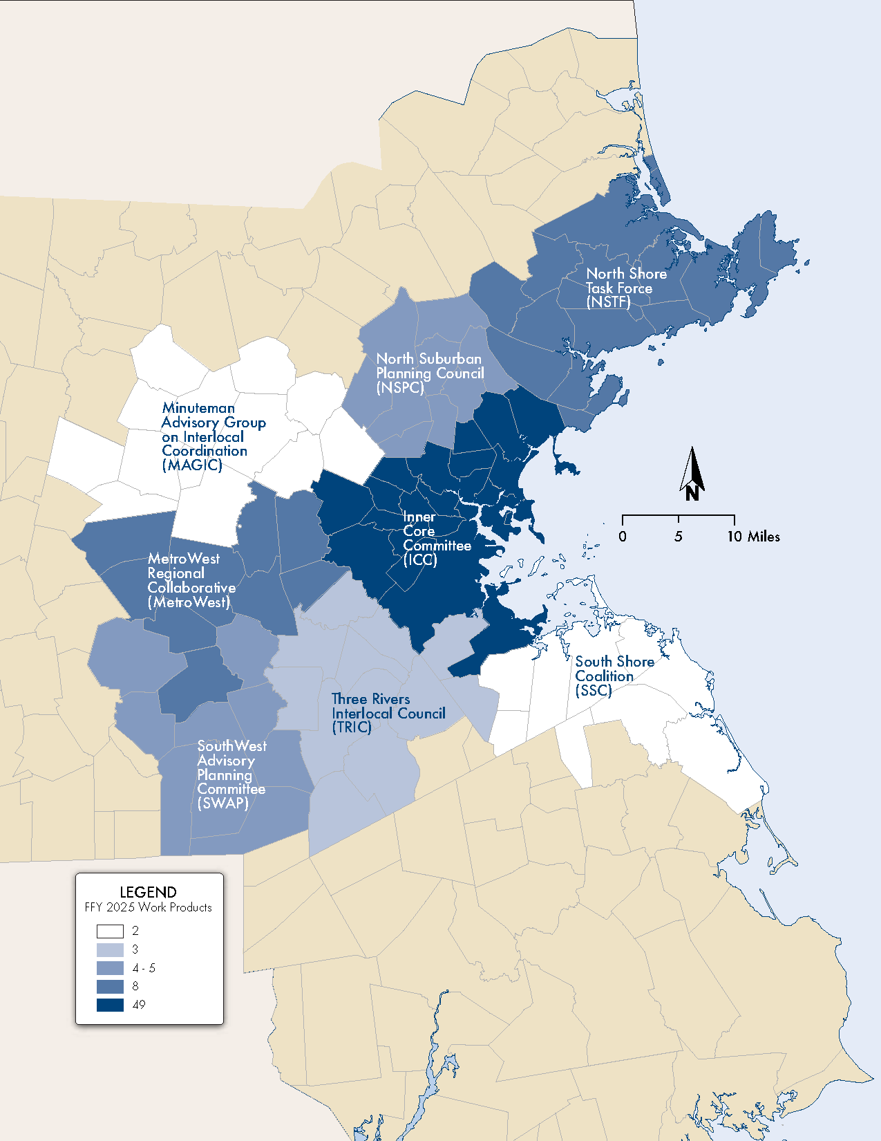
Notes:
Needham, Dover, and Milton were included exclusively in the TRIC subregion for this analysis.
As noted above, staff analyzed the geographic distribution of UPWP studies and technical analyses between FFYs 2021 and 2025. To generate information on the number of UPWP studies during these FFYs that benefited specific cities and towns in the Boston region, MPO staff performed the following tasks:
Table D-2 shows the number of completed MPO-funded UPWP work products from FFY 2021 through FFY 2025 that are determined to provide benefits to specific municipalities. Studies and technical analyses are grouped by the year in which they were completed, rather than the year in which they were first programmed in the UPWP. Examples of the types of studies and work in the table include the following:
Figure D-2 maps the number of completed work products that benefited each subregion for FFY 2025.
The data in the tables show that there is a slight positive relationship between the percentage of Title VI populations in each municipality and the number of studies conducted in each municipality since 2021, but not a strong correlation. This suggests that studies are not always distributed relative to the share of Title VI populations; if they were, the number of studies would be expected to increase with the share of Title VI populations.
With regards to geographic distribution, the Inner Core Committee (ICC) subregion, has had the most studies since 2021, with 150, but also the highest population, with 1,759,970 people. In 2025, the ICC also had the highest number of work products, followed by the MetroWest Regional Collaborative (MetroWest) and the NorthShore Task Force (NSTF). The South Shore Coalition (SCC) had the lowest. This suggests that municipalities in the ICC, MetroWest, and NSTF subregions received disproportionately more studies than municipalities in other subregions in 2025.
As the MPO considers studies to fund in future years, it should consider prioritizing funding in those municipalities that have received less funding in the past and based on shares of Title VI populations.
Table D-2
Number of UPWP Tasks by FFY and Municipality, Grouped by Subregion
| Municipality | Number of Work Products | Demographics | ||||||||
| 2021 | 2022 | 2023 | 2024 | 2025 | 2021-25 Total | Total Population | Percent Minority | Percentage of Residents with LEP | Median Income | |
| Arlington | 0 | 0 | 3 | 1 | 1 | 5 | 46,308 | 24.8% | 5.2% | $ 141,440 |
| Belmont | 0 | 1 | 0 | 0 | 0 | 1 | 27,295 | 30.4% | 7.6% | $ 178,188 |
| Boston | 5 | 11 | 8 | 5 | 8 | 37 | 675,647 | 55.4% | 15.5% | $ 94,755 |
| Brookline | 0 | 1 | 2 | 1 | 1 | 5 | 63,191 | 34.7% | 7.3% | $ 140,631 |
| Cambridge | 0 | 0 | 2 | 1 | 1 | 4 | 118,403 | 44.6% | 7.9% | $ 126,469 |
| Chelsea | 1 | 0 | 3 | 1 | 6 | 11 | 40,787 | 79.8% | 42.7% | $ 72,220 |
| Everett | 0 | 0 | 3 | 4 | 6 | 13 | 49,075 | 65.9% | 32.1% | $ 79,658 |
| Lynn | 1 | 1 | 2 | 0 | 0 | 4 | 101,253 | 65.9% | 25.8% | $ 74,715 |
| Malden | 1 | 0 | 3 | 1 | 4 | 9 | 66,263 | 60.0% | 26.0% | $ 95,298 |
| Medford | 0 | 0 | 1 | 1 | 4 | 6 | 59,659 | 33.2% | 10.0% | $ 118,089 |
| Melrose | 1 | 0 | 2 | 0 | 0 | 3 | 29,817 | 20.4% | 6.5% | $ 126,854 |
| Newton | 0 | 1 | 2 | 1 | 2 | 6 | 88,923 | 29.9% | 7.9% | $ 184,989 |
| Quincy | 2 | 3 | 3 | 1 | 1 | 10 | 101,636 | 45.8% | 19.8% | $ 95,711 |
| Revere | 1 | 0 | 3 | 1 | 5 | 10 | 62,186 | 55.1% | 32.1% | $ 81,121 |
| Saugus | 0 | 0 | 0 | 0 | 0 | 0 | 28,619 | 24.9% | 8.4% | $ 100,819 |
| Somerville | 2 | 0 | 5 | 1 | 5 | 13 | 81,045 | 34.8% | 10.5% | $ 127,056 |
| Waltham | 0 | 1 | 0 | 0 | 0 | 1 | 65,218 | 39.6% | 10.1% | $ 116,560 |
| Watertown | 0 | 1 | 2 | 1 | 4 | 8 | 35,329 | 26.9% | 9.8% | $ 123,422 |
| Winthrop | 0 | 0 | 2 | 1 | 1 | 4 | 19,316 | 21.1% | 8.4% | $ 106,357 |
| ICC Subtotals | 14 | 20 | 46 | 21 | 49 | 150 | 1,759,970 | 48.2% | 15.7% | |
| Acton | 0 | 0 | 1 | 2 | 0 | 3 | 24,021 | 36.9% | 8.8% | $ 153,338 |
| Bedford | 0 | 1 | 2 | 1 | 0 | 4 | 14,383 | 26.5% | 6.0% | $ 158,964 |
| Bolton | 0 | 0 | 0 | 0 | 0 | 0 | 5,665 | 13.5% | 1.8% | $ 198,475 |
| Boxborough | 0 | 0 | 0 | 0 | 0 | 0 | 5,506 | 32.9% | 6.4% | $ 151,000 |
| Carlisle | 0 | 0 | 0 | 0 | 0 | 0 | 5,237 | 21.2% | 2.7% | $ 250,001 |
| Concord | 2 | 1 | 3 | 0 | 1 | 7 | 18,491 | 18.2% | 1.8% | $ 212,315 |
| Hudson | 1 | 0 | 0 | 0 | 0 | 1 | 20,092 | 21.4% | 9.6% | $ 107,202 |
| Lexington | 1 | 1 | 1 | 0 | 0 | 3 | 34,454 | 43.3% | 8.6% | $ 219,402 |
| Lincoln | 1 | 0 | 1 | 0 | 1 | 3 | 7,014 | 23.8% | 4.7% | $ 180,750 |
| Littleton | 0 | 0 | 1 | 0 | 0 | 1 | 10,141 | 16.9% | 2.4% | $ 146,250 |
| Maynard | 0 | 0 | 1 | 1 | 0 | 2 | 10,746 | 17.0% | 4.8% | $ 119,549 |
| Stow | 0 | 0 | 0 | 1 | 0 | 1 | 7,174 | 14.3% | 3.1% | $ 177,862 |
| Sudbury | 1 | 1 | 3 | 0 | 0 | 5 | 18,934 | 19.1% | 2.4% | $ 234,634 |
| MAGIC Subtotals | 6 | 4 | 13 | 5 | 2 | 30 | 181,858 | 26.8% | 5.8% | |
| Ashland | 1 | 0 | 1 | 1 | 0 | 3 | 18,832 | 31.5% | 7.8% | $ 127,106 |
| Framingham | 1 | 1 | 2 | 1 | 3 | 8 | 72,362 | 46.3% | 19.8% | $ 98,179 |
| Holliston | 1 | 0 | 0 | 1 | 0 | 2 | 14,996 | 15.8% | 4.0% | $ 154,684 |
| Marlborough | 1 | 0 | 0 | 0 | 1 | 2 | 41,793 | 40.9% | 18.3% | $ 95,047 |
| Natick | 1 | 1 | 0 | 1 | 3 | 6 | 37,006 | 24.4% | 8.0% | $ 134,591 |
| Southborough | 1 | 0 | 0 | 1 | 0 | 2 | 10,450 | 24.5% | 6.3% | $ 192,006 |
| Wayland | 1 | 1 | 0 | 0 | 0 | 2 | 13,943 | 23.2% | 5.7% | $ 221,250 |
| Wellesley | 1 | 0 | 0 | 0 | 1 | 2 | 29,550 | 26.7% | 5.5% | $ 250,001 |
| Weston | 1 | 0 | 1 | 0 | 0 | 2 | 11,851 | 26.0% | 4.5% | $ 250,001 |
| MetroWest Subtotals | 9 | 3 | 4 | 5 | 8 | 29 | 250,783 | 33.8% | 12.1% | |
| Burlington | 0 | 0 | 0 | 1 | 2 | 3 | 26,377 | 30.0% | 4.7% | $ 142,207 |
| Lynnfield | 0 | 0 | 0 | 0 | 1 | 1 | 13,000 | 13.5% | 3.3% | $ 172,484 |
| North Reading | 0 | 0 | 0 | 1 | 0 | 1 | 15,554 | 11.5% | 1.7% | $ 150,820 |
| Reading | 0 | 0 | 0 | 0 | 0 | 0 | 25,518 | 12.8% | 3.1% | $ 163,725 |
| Stoneham | 0 | 0 | 0 | 0 | 0 | 0 | 23,244 | 18.6% | 6.3% | $ 112,635 |
| Wakefield | 1 | 1 | 2 | 1 | 0 | 5 | 27,090 | 14.3% | 3.5% | $ 130,320 |
| Wilmington | 0 | 0 | 0 | 0 | 0 | 0 | 23,349 | 13.8% | 1.9% | $ 161,473 |
| Winchester | 0 | 0 | 0 | 0 | 0 | 0 | 22,970 | 25.4% | 6.0% | $ 218,176 |
| Woburn | 0 | 0 | 0 | 0 | 2 | 2 | 40,876 | 27.2% | 9.1% | $ 107,754 |
| NSPC Subtotals | 1 | 1 | 2 | 3 | 5 | 12 | 217,978 | 19.8% | 4.9% | |
| Beverly | 0 | 1 | 1 | 0 | 1 | 3 | 42,670 | 15.4% | 4.2% | $ 103,739 |
| Danvers | 0 | 1 | 0 | 0 | 1 | 2 | 28,087 | 12.7% | 3.8% | $ 117,072 |
| Essex | 0 | 0 | 0 | 0 | 1 | 1 | 3,675 | 7.5% | 0.8% | $ 152,371 |
| Gloucester | 0 | 0 | 0 | 0 | 0 | 0 | 29,729 | 11.7% | 5.7% | $ 87,898 |
| Hamilton | 0 | 0 | 0 | 1 | 0 | 1 | 7,561 | 11.1% | 2.1% | $ 126,331 |
| Ipswich | 0 | 0 | 0 | 1 | 0 | 1 | 13,785 | 9.0% | 2.0% | $ 124,405 |
| Manchester-by-the-Sea | 0 | 1 | 1 | 0 | 0 | 2 | 5,395 | 6.7% | 0.2% | $ 197,875 |
| Marblehead | 0 | 0 | 0 | 0 | 0 | 0 | 20,441 | 9.2% | 1.6% | $ 165,859 |
| Middleton | 0 | 0 | 0 | 0 | 0 | 0 | 9,779 | 15.7% | 7.0% | $ 171,458 |
| Nahant | 0 | 0 | 0 | 0 | 0 | 0 | 3,334 | 9.0% | 0.8% | $ 111,004 |
| Peabody | 0 | 1 | 0 | 0 | 1 | 2 | 54,481 | 22.7% | 10.0% | $ 95,278 |
| Rockport | 0 | 0 | 0 | 0 | 0 | 0 | 6,992 | 6.9% | 0.9% | $ 93,227 |
| Salem | 1 | 2 | 2 | 2 | 4 | 11 | 44,480 | 31.5% | 9.4% | $ 85,137 |
| Swampscott | 0 | 0 | 0 | 0 | 0 | 0 | 15,111 | 14.2% | 10.0% | $ 128,964 |
| Topsfield | 0 | 0 | 0 | 0 | 0 | 0 | 6,569 | 10.0% | 3.0% | $ 176,698 |
| Wenham | 0 | 0 | 0 | 0 | 0 | 0 | 4,979 | 12.6% | 2.7% | $ 187,652 |
| NSTF Subtotals | 1 | 6 | 4 | 4 | 8 | 23 | 297,068 | 16.9% | 5.9% | |
| Braintree | 0 | 1 | 1 | 0 | 0 | 2 | 39,143 | 29.9% | 11.0% | $ 125,305 |
| Cohasset | 0 | 1 | 0 | 0 | 0 | 1 | 8,381 | 7.2% | 2.0% | $ 187,060 |
| Hingham | 1 | 2 | 0 | 1 | 0 | 4 | 24,284 | 8.5% | 1.8% | $ 181,017 |
| Holbrook | 0 | 0 | 0 | 1 | 1 | 2 | 11,405 | 34.4% | 3.0% | $ 107,768 |
| Hull | 0 | 1 | 1 | 0 | 0 | 2 | 10,072 | 8.3% | 0.4% | $ 127,112 |
| Marshfield | 0 | 1 | 0 | 0 | 0 | 1 | 25,825 | 6.8% | 0.9% | $ 125,525 |
| Norwell | 1 | 1 | 0 | 0 | 0 | 2 | 11,351 | 8.8% | 1.6% | $ 182,637 |
| Rockland | 0 | 0 | 0 | 1 | 0 | 1 | 17,803 | 17.5% | 4.6% | $ 101,475 |
| Scituate | 0 | 1 | 0 | 0 | 0 | 1 | 19,063 | 6.6% | 1.5% | $ 131,861 |
| Weymouth | 0 | 1 | 0 | 2 | 1 | 4 | 57,437 | 22.6% | 5.7% | $ 100,077 |
| SSC Subtotals | 1 | 9 | 2 | 5 | 2 | 19 | 224,764 | 17.5% | 4.5% | |
| Bellingham | 0 | 0 | 0 | 0 | 2 | 2 | 16,945 | 14.6% | 3.0% | $ 120,966 |
| Franklin | 0 | 0 | 0 | 0 | 1 | 1 | 33,261 | 14.9% | 3.6% | $ 142,788 |
| Hopkinton | 0 | 0 | 0 | 0 | 1 | 1 | 18,758 | 26.8% | 3.4% | $ 204,418 |
| Medway | 0 | 1 | 1 | 0 | 0 | 2 | 13,115 | 11.7% | 3.3% | $ 174,357 |
| Milford | 1 | 0 | 0 | 0 | 0 | 1 | 30,379 | 34.0% | 20.8% | $ 92,726 |
| Millis | 0 | 0 | 0 | 0 | 0 | 0 | 8,460 | 12.0% | 5.0% | $ 149,021 |
| Norfolk | 0 | 0 | 0 | 1 | 0 | 1 | 11,662 | 15.9% | 0.4% | $ 197,379 |
| Sherborn | 1 | 0 | 0 | 0 | 0 | 1 | 4,401 | 18.3% | 0.9% | $ 247,500 |
| Wrentham | 1 | 0 | 0 | 1 | 0 | 2 | 12,178 | 10.4% | 1.4% | $ 147,930 |
| SWAP Subtotals | 3 | 1 | 1 | 2 | 4 | 11 | 149,159 | 19.6% | 6.5% | |
| Canton | 0 | 1 | 1 | 0 | 0 | 2 | 24,370 | 27.1% | 5.3% | $ 128,341 |
| Dedham | 1 | 1 | 0 | 1 | 0 | 3 | 25,364 | 22.0% | 6.2% | $ 124,375 |
| Dover | 1 | 0 | 0 | 0 | 0 | 1 | 5,923 | 19.2% | 2.1% | $ 250,001 |
| Foxborough | 1 | 0 | 0 | 0 | 0 | 1 | 18,618 | 16.4% | 3.4% | $ 108,559 |
| Medfield | 1 | 0 | 0 | 0 | 0 | 1 | 12,799 | 12.5% | 0.7% | $ 214,801 |
| Milton | 3 | 2 | 1 | 1 | 1 | 8 | 28,630 | 29.0% | 3.8% | $ 178,053 |
| Needham | 0 | 1 | 1 | 1 | 0 | 3 | 32,091 | 18.9% | 4.6% | $ 212,241 |
| Norwood | 1 | 2 | 2 | 0 | 0 | 5 | 31,611 | 27.5% | 12.3% | $ 97,110 |
| Randolph | 0 | 1 | 1 | 1 | 0 | 3 | 34,984 | 73.4% | 17.3% | $ 103,129 |
| Sharon | 0 | 0 | 1 | 1 | 1 | 3 | 18,575 | 33.2% | 6.2% | $ 183,724 |
| Walpole | 1 | 1 | 0 | 0 | 1 | 3 | 26,383 | 17.1% | 3.6% | $ 159,720 |
| Westwood | 1 | 1 | 0 | 0 | 0 | 2 | 16,266 | 17.2% | 3.4% | $ 205,000 |
| TRIC Subtotals | 10 | 10 | 7 | 5 | 3 | 35 | 275,614 | 29.1% | 6.9% | |
| Grand Total | 45 | 54 | 79 | 50 | 81 | 309 | 3,357,194 | 36.5% | 11.4% | |
Notes:
LEP percentage is tabulated for the population aged five years and older and the minority population percentage is tabulated for the total population for each municipality in the entire region.
People who identify as minority are those who identify as a race other than White or as Hispanic or Latino/a/x.
Needham, Dover, and Milton were included exclusively in the TRIC subregion for this analysis.
Sources:
Minority population: US Census Bureau; 2020 Decennial Census Demographic and Housing Characteristics, Table P5: Hispanic or Latino Origin by Race; data.census.gov; (2025-03-26).
People with LEP: US Census Bureau; 2019–23 American Community Survey, Table C16001: Language Spoken at Home for the Population 5 Years and Over; data.census.gov; (2025-03-26).
Median Household Income: U.S. Census Bureau; American Community Survey, 2019-2023 American Community Survey 5-Year Estimates, Table B19013 (Median Household Income), generated by CTPS; using api.census.gov; (2025-03-26).
Figure D-2
Map of 2025 UPWP Tasks by Municipality
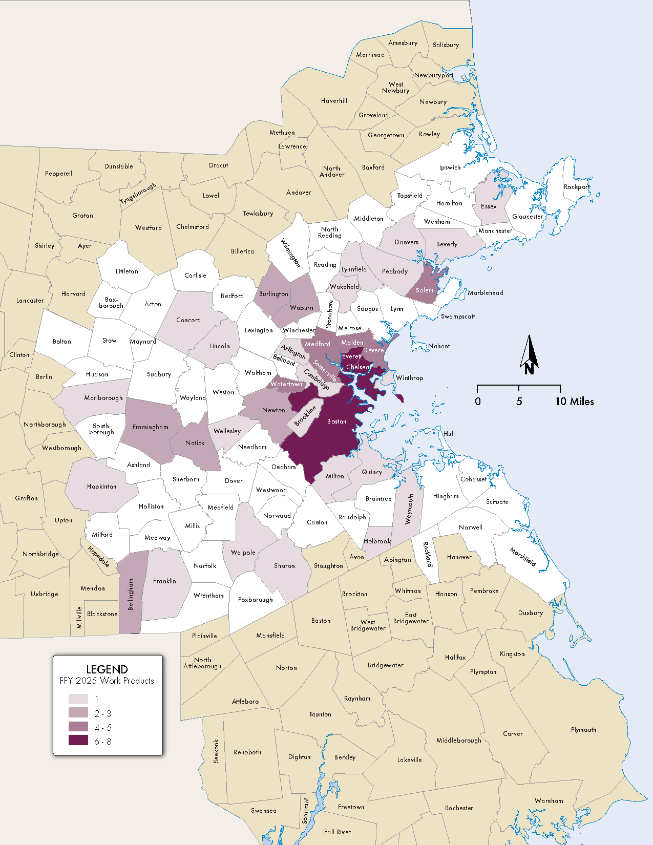
Notes:
Needham, Dover, and Milton were included exclusively in the TRIC subregion for this analysis.
In addition to work that benefits specific municipalities, many projects funded by the MPO through the UPWP have a regional focus. Table D-3 lists MPO-funded UPWP studies completed from 2021 through 2025 that were regional in focus, meaning that they provided benefit to multiple communities and types of municipalities. Some regionally focused studies may have work products that overlap with those analyzed in the tables above.
More information on these studies and other work can be found on the MPO’s website (https://www.bostonmpo.org/recent_studies) or by contacting Olivia Saccocia, UPWP Manager, at osaccocia@ctps.org.
Table D-3
Regionally Focused MPO-Funded UPWP Studies
| FFY 2025 | |
| Boston Region MPO | MAPC |
| - Bluebikes and MBTA Connections - Decarbonizing the Freight Sector: Exploring the Potential for Using E-cargo Bikes for First-/Last-mile Freight Deliveries - Roadway Pricing: Balancing the Need for a Transition to Sustainable Mobility with Equity Considerations |
- Research and Evaluation that Support Livable Communities and Sustainable Transportation |
| FFY 2024 | |
| Boston Region MPO | MAPC |
| - Lab and Municipal Parking Phase II - Parking in Bike Lanes: Strategies for Safety and Prevention - Strategies for Environmental Outreach and Engagement - Applying Conveyal to TIP Project Scoring |
Blank |
| FFY 2023 | |
| Boston Region MPO | MAPC |
| - Update Bicycle/Pedestrian Count Database - Flexible Fixed-Route Bus Service - Transit Modernization Program - Lab and Municipal Parking Study - Learning from Roadway Pricing Experiences |
Blank |
| FFY 2022 | |
| Boston Region MPO | MAPC |
| - Trip Generation Follow-up - Travel Demand Management Follow-up - The Future of the Curb Phase 3 - Identifying Transportation Inequities in the Boston Region - Staff Generated Research Topics |
- MetroCommon 2050: Greater Boston’s Next Regional Vision |
| FFY 2021 | |
| Boston Region MPO | MAPC |
| - Improving Pedestrian Variables in the Travel Demand Model - Regional TDM Strategies - Trip Generation Rate Research - Access to CBDs Phase 2 - The Future of the Curb Phase 2 - Multimodal Resilience and Emergency Planning - MPO Staff-Generated Research Topics - Mapping Major Transportation Infrastructure Projects in the Boston Region - Exploring Resilience in MPO-Funded Corridor and Intersection Studies |
- Rideshare Electrification Working Group - Impacts of E-commerce in Massachusetts - Planning Successful Bus Priority Projects in Greater Boston - MetroCommon Regional Plan Development |
MPO staff collects these data annually. These data can potentially be used to inform UPWP funding decisions and could be used in concert with other data in the following future analyses:
Analyses such as these would provide the MPO with a clearer understanding of how the work programmed through the UPWP addresses the needs of the region.
This appendix contains detailed background on the regulatory documents, legislation, and guidance that shape the Boston Region Metropolitan Planning Organization’s (MPO) transportation planning process.
The Boston Region MPO is charged with executing its planning activities in line with federal and state regulatory guidance. Maintaining compliance with these regulations allows the MPO to directly support the work of these critical partners and ensures its continued role in helping the region move closer to achieving federal, state, and regional transportation goals. This appendix describes the regulations, policies, and guidance taken into consideration by the MPO during development of the certification documents and other core work the MPO will undertake during federal fiscal year (FFY) 2026.
The MPO’s planning processes are guided by provisions in federal transportation authorization bills, which are codified in federal statutes and supported by guidance from federal agencies. The Bipartisan Infrastructure Law (BIL) was signed into law on November 15, 2021, as the nation’s five-year surface transportation bill, and covers FFYs 2022–26. This section describes new provisions established in the BIL.
The purpose of the national transportation goals, outlined in Title 23, section 150, of the United States Code (23 USC § 150), is to increase the accountability and transparency of the Federal-Aid Highway Program and to improve decision-making through performance-based planning and programming. The national transportation goals include the following:
The Boston Region MPO has incorporated these national goals, where practicable, into its vision, goals, and objectives, which provide a framework for the MPO’s planning processes. More information about the MPO’s vision, goals, and objectives is included in Chapter 1.
The MPO gives specific consideration to the federal planning factors, described in Title 23, section 134, of the US Code (23 USC § 134), when developing all documents that program federal transportation funds. In accordance with the legislation, studies and strategies undertaken by the MPO shall
The Boston Region MPO has also incorporated these federal planning factors into its vision, goals, and objectives. Table E-1 shows the relationships between FFY 2026 MPO studies and activities and these federal planning factors.
Table E-1
FFY 2026 3C-Funded UPWP Studies and Programs—Relationship to Federal Planning Factors
| Federal Planning Factor | 3C-funded Certification Activities | Ongoing Technical Assistance | New and Recurring 3C-funded Planning Studies* | Administration and Resource Management | MAPC Activities | |||||||||||||||||||||||||||
| Support to the MPO and its Committees | General Editorial | General Graphics | Public Engagement Program | Long-Range Transportation Plan | Transportation Improvement Program | Performance-Based Planning and Programming | Unified Planning Work Program | Community Transportation Access Program | Congestion Management Process | Multimodal Mobility Infrastructure Program | Freight Planning Support | Data Program | Transit Working Group Support | Active Transportation Planning Program | Transportation Impact Mitigation | Road Safety Audits | Technical Assistance Program (Boston Region MPO and MAPC) | Pedestrian-Scale Lighting Guide for Communities | Representing the Experience of Limited Mobility Individuals | Roadway Pricing: Stakeholder Analysis | IT Resource Management | Professional Development | Corridor/Subarea Planning Studies | Alternative Mode Planning and Coordination | MetroCommon 2050 | Land-Use Development Project Reviews | MPO/MAPC Liaison Activities | UPWP Support | Land-use Data and Forecasts for Transportation Modeling | Subregional Support Activities | ||
| 1 | Support the economic vitality of the metropolitan area, especially by enabling global competitiveness, productivity, and efficiency. | • | • | • | • | • | • | • | • | • | • | • | • | • | • | • | • | • | • | • | • | |||||||||||
| 2 | Increase the safety of the transportation system for all motorized and nonmotorized users. | • | • | • | • | • | • | • | • | • | • | • | • | • | • | • | • | • | • | • | ||||||||||||
| 3 | Increase the ability of the transportation system to support homeland security and to safeguard the personal security of all motorized and nonmotorized users. | • | • | • | • | • | • | • | ||||||||||||||||||||||||
| 4 | Increase accessibility and mobility of people and freight. | • | • | • | • | • | • | • | • | • | • | • | • | • | • | • | • | • | • | • | • | • | • | • | • | • | • | • | ||||
| 5 | Protect and enhance the environment, promote energy conservation, improve the quality of life, and promote consistency between transportation improvements and state and local planned growth and economic development patterns. | • | • | • | • | • | • | • | • | • | • | • | • | • | • | • | • | • | • | • | • | • | • | • | • | |||||||
| 6 | Enhance the integration and connectivity of the transportation system, across and between modes, for people and freight. | • | • | • | • | • | • | • | • | • | • | • | • | • | • | • | • | • | • | • | • | • | • | |||||||||
| 7 | Promote efficient system management and operation. | • | • | • | • | • | • | • | • | • | • | • | • | • | • | • | • | • | • | • | • | |||||||||||
| 8 | Emphasize the preservation of the existing transportation system. | • | • | • | • | • | • | • | • | • | • | • | • | • | • | • | • | |||||||||||||||
| 9 | Improve the resiliency and reliability of the transportation system and reduce or mitigate storm water impacts of surface transportation. | • | • | • | • | • | • | • | • | • | • | • | • | • | • | • | • | |||||||||||||||
| 10 | Enhance travel and tourism. | • | • | • | • | • | • | • | • | • | • | • | • | • | ||||||||||||||||||
* For ongoing FFY 2025 3C-funded studies, see FFY 2025 UPWP
** Includes Support to the MPO and its Committees, Public Participation Process, and Regional Transportation Advisory Council Support
The United States Department of Transportation (USDOT), in consultation with states, MPOs, and other stakeholders, established performance measures relevant to the national goals established in the FAST Act. These performance topic areas include roadway safety, transit system safety, National Highway System (NHS) bridge and pavement condition, transit asset condition, NHS reliability for both passenger and freight travel, traffic congestion, and on-road mobile source emissions. The FAST Act and related federal rulemakings require states, MPOs, and public transportation operators to follow performance-based planning and programming practices—such as setting targets—to ensure that transportation investments support progress towards these goals. See Chapter 3 for more information about how the MPO has and will continue to conduct performance-based planning and programming.
The Clean Air Act, most recently amended in 1990, forms the basis of the United States’ air pollution control policy. The act identifies air quality standards, and the US Environmental Protection Agency (EPA) designates geographic areas as attainment (in compliance) or nonattainment (not in compliance) areas with respect to these standards. If air quality in a nonattainment area improves such that it meets EPA standards, the EPA may redesignate that area as being a maintenance area for a 20-year period to ensure that the standard is maintained in that area.
The conformity provisions of the Clean Air Act “require that those areas that have poor air quality, or had it in the past, should examine the long-term air quality impacts of their transportation system and ensure its compatibility with the area’s clean air goals.” Agencies responsible for Clean Air Act requirements for nonattainment and maintenance areas must conduct air quality conformity determinations, which are demonstrations that transportation plans, programs, and projects addressing that area are consistent with a State Implementation Plan (SIP) for attaining air quality standards.
Air quality conformity determinations must be performed for capital improvement projects that receive federal funding and for those that are considered regionally significant, regardless of the funding source. These determinations must show that projects in the MPO’s Long-Range Transportation Plan (LRTP) and Transportation Improvement Program (TIP) will not cause or contribute to any new air quality violations; will not increase the frequency or severity of any existing air quality violations in any area; and will not delay the timely attainment of air quality standards in any area. The policy, criteria, and procedures for demonstrating air quality conformity in the Boston region were established in Title 40, parts 51 and 53, of the Code of Federal Regulations (40. C.F.R. 51, 40 C.F.R. 53).
On April 1, 1996, the EPA classified the cities of Boston, Cambridge, Chelsea, Everett, Malden, Medford, Quincy, Revere, and Somerville as in attainment for carbon monoxide (CO) emissions. Subsequently, the Commonwealth established a CO maintenance plan through the Massachusetts SIP process to ensure that emission levels did not increase. While the maintenance plan was in effect, past TIPs and LRTPs included an air quality conformity analysis for these communities. As of April 1, 2016, the 20-year maintenance period for this maintenance area expired and transportation conformity is no longer required for carbon monoxide in these communities. This ruling is documented in a letter from the EPA dated May 12, 2016.
On April 22, 2002, the EPA classified the City of Waltham as being in attainment for CO emissions with an EPA-approved limited-maintenance plan. In areas that have approved limited-maintenance plans, federal actions requiring conformity determinations under the EPA’s transportation conformity rule are considered to satisfy the conformity test. The MPO is not required to perform a modeling analysis for a conformity determination for carbon monoxide, but it has been required to provide a status report on the timely implementation of projects and programs that will reduce emissions from transportation sources—so-called transportation control measures—which are included in the Massachusetts SIP. In April 2022, the EPA issued a letter explaining that the carbon monoxide limited maintenance area in Waltham has expired. Therefore, the MPO is no longer required to demonstrate transportation conformity for this area, but the rest of the maintenance plan requirements, however, continue to apply, in accordance with the SIP.
On February 16, 2018, the US Court of Appeals for the DC Circuit issued a decision in South Coast Air Quality Management District v. EPA, which struck down portions of the 2008 Ozone National Ambient Air Quality Standards (NAAQS) SIP Requirements Rule concerning the ozone NAAQS. Those portions of the SIP Requirements Rule included transportation conformity requirements associated with the EPA’s revocation of the 1997 ozone NAAQS. Massachusetts was designated as an attainment area in accord with the 2008 ozone NAAQS but as a nonattainment or maintenance area as relates to the 1997 ozone NAAQS. As a result of this court ruling, MPOs in Massachusetts must once again demonstrate conformity for ozone when developing LRTPs and TIPs.
MPOs must also perform conformity determinations if transportation control measures (TCM) are in effect in the region. TCMs are strategies that reduce transportation-related air pollution and fuel use by reducing vehicle-miles traveled and improving roadway operations. The Massachusetts SIP identifies TCMs in the Boston region. SIP-identified TCMs are federally enforceable and projects that address the identified air quality issues must be given first priority when federal transportation dollars are spent. Examples of TCMs that were programmed in previous TIPs include rapid-transit and commuter-rail extension programs (such as the Green Line Extension in Cambridge, Medford, and Somerville, and the Fairmount Line improvements in Boston), parking-freeze programs in Boston and Cambridge, statewide rideshare programs, park-and-ride facilities, residential parking-sticker programs, and the operation of high-occupancy-vehicle (HOV) lanes.
In addition to reporting on the pollutants identified in the 1990 Clean Air Act Amendments, the MPOs in Massachusetts are also required to perform air quality analyses for carbon dioxide as part of the state’s Global Warming Solutions Act (GWSA) (see below).
The Boston Region MPO complies with Title VI of the Civil Rights Act of 1964, the American with Disabilities Act of 1990 (ADA), and other federal and state nondiscrimination statutes and regulations in all programs and activities it conducts. Per federal and state law, the MPO does not discriminate on the basis of race, color, national origin (including limited-English proficiency), disability, age, sex, and additional protected characteristics. The MPO strives to provide meaningful opportunities for participation of all persons in the region, including those protected by Title VI, the ADA, and other nondiscrimination mandates.
The MPO also assesses the likely benefits and adverse effects of transportation projects on protected populations (populations covered by federal regulations, as identified in the MPO’s Community Transportation Access program) when deciding which projects to fund. This is done through the MPO’s project selection criteria. MPO staff also evaluate the projects that are selected for funding, in the aggregate, to determine their overall impacts and whether they improve transportation outcomes for protected populations. The major federal requirements pertaining to nondiscrimination are discussed below.
Title VI of the Civil Rights Act of 1964 requires that no person be excluded from participation in, be denied the benefits of, or be subjected to discrimination on the basis of race, color, or national origin, under any program or activity provided by an agency receiving federal financial assistance. Executive Order 13166—Improving Access to Services for Persons with Limited English Proficiency, dated August 11, 2000, extends Title VI protections to people who, as a result of their nationality, have limited English proficiency. Specifically, it calls for improved access to federally assisted programs and activities, and it requires MPOs to develop and implement a system through which people with limited English proficiency can meaningfully participate in the transportation planning process. This requirement includes the development of a Language Assistance Plan that documents the organization’s process for providing meaningful language access to people with limited English proficiency who access their services and programs.
Title III of the ADA “prohibits states, MPOs, and other public entities from discriminating on the basis of disability in the entities’ services, programs, or activities,” and requires all transportation projects, plans, and programs to be accessible to people with disabilities. Therefore, MPOs must consider the mobility needs of people with disabilities when programming federal funding for studies and capital projects. MPO-sponsored meetings must also be held in accessible venues and be conducted in a manner that provides for accessibility. Also, MPO materials must be made available in accessible formats.
The Age Discrimination Act of 1975 prohibits discrimination on the basis of age in programs or activities that receive federal financial assistance. In addition, the Rehabilitation Act of 1975, and Title 23, section 324, of the US Code (23 USC § 324) prohibit discrimination based on sex.
Much of the MPO’s work focuses on encouraging mode shift and diminishing GHG emissions through improving transit service, enhancing bicycle and pedestrian networks, and studying emerging transportation technologies. All of this work helps the Boston region contribute to statewide progress towards the priorities discussed in this section.
Beyond Mobility, the Massachusetts 2050 Transportation Plan, is a planning process that will result in a blueprint for guiding transportation decision-making and investments in Massachusetts. MPO staff continue to coordinate with MassDOT staff so that Destination 2050, the MPO’s Long-Range Transportation Plan, is aligned with the Beyond Mobility plan.
The Commission on the Future of Transportation in the Commonwealth—established by Massachusetts Governor Charlie Baker’s Executive Order 579—published Choices for Stewardship in 2019. This report makes 18 recommendations across the following five thematic categories to adapt the transportation system in the Commonwealth to emerging needs:
Beyond Mobility builds upon the Commission report’s recommendations. The Boston Region MPO supports these statewide goals by conducting planning work and making investment decisions that complement MassDOT’s efforts and reflect the evolving needs of the transportation system in the region.
The Massachusetts 2023 Strategic Highway Safety Plan (SHSP) identifies the state’s key safety needs and guides investment decisions to achieve significant reductions in highway fatalities and serious injuries on all public roads. The SHSP establishes statewide safety goals and objectives and key safety emphasis areas, and it draws on the strengths of all highway safety partners in the Commonwealth to align and leverage resources to address the state’s safety challenges collectively. The Boston Region MPO considers SHSP goals, emphasis areas, and strategies when developing its plans, programs, and activities.
The Massachusetts Transportation Asset Management Plan (TAMP) is a risk-based asset management plan for the bridges and pavement that are in the NHS inventory. The plan describes the condition of these assets, identifies assets that are particularly vulnerable following declared emergencies such as extreme weather, and discusses MassDOT’s financial plan and risk management strategy for these assets. The Boston Region MPO considers MassDOT TAMP goals, targets, and strategies when developing its plans, programs, and activities. MassDOT’s TAMP was most recently updated in 2023.
In 2018, MassDOT released the related Commonwealth of Massachusetts State Rail Plan, which outlines short- and long-term investment strategies for Massachusetts’ freight and passenger rail systems (excluding the commuter rail system). In 2019, MassDOT released the Massachusetts Bicycle Transportation Plan and the Massachusetts Pedestrian Transportation Plan, both of which define roadmaps, initiatives, and action plans to improve bicycle and pedestrian transportation in the Commonwealth. These plans were updated in 2021 to reflect new investments in bicycle and pedestrian projects made by MassDOT since their release. In 2023, MassDOT released the Massachusetts Freight Plan, which identifies short- and long-term improvements and strategies for the state’s freight systems. The MPO considers the findings and strategies of MassDOT’s modal plans when conducting its planning, including through its Freight Planning Support and Bicycle/Pedestrian Support Activities programs.
The GWSA makes Massachusetts a leader in setting aggressive and enforceable GHG reduction targets and implementing policies and initiatives to achieve these targets. In keeping with this law, the Massachusetts Executive Office of Energy and Environmental Affairs (EEA), in consultation with other state agencies and the public, developed the Massachusetts Clean Energy and Climate Plan for 2020. This implementation plan, released on December 29, 2010, and updated in 2022 to reflect new interim targets, establishes the following targets for overall statewide GHG emission reductions:
In 2018, EEA published its GWSA 10-year Progress Report and the GHG Inventory estimated that 2018 GHG emissions were 22 percent below the 1990 baseline level.
On June 30, 2022, EEA certified its compliance with the 2020 emissions limit of 25 percent below the 1990 levels, noting that there was an estimated emissions reduction of 31.4 percent below the 1990 level in 2020.
MassDOT fulfills its responsibilities, defined in the Massachusetts Clean Energy and Climate Plan for 2050, through a policy directive that sets three principal objectives:
In January 2015, the Massachusetts Department of Environmental Protection amended Title 310, section 7.00, of the Code of Massachusetts Regulations (310 CMR 60.05), Global Warming Solutions Act Requirements for the Transportation Sector and the Massachusetts Department of Transportation, which was subsequently amended in August 2017. This regulation places a range of obligations on MassDOT and MPOs to support achievement of the Commonwealth’s climate change goals through the programming of transportation funds. For example, MPOs must use GHG impact as a selection criterion when they review projects to be programmed in their TIPs, and they must evaluate and report the GHG emissions impacts of transportation projects in LRTPs and TIPs.
The Commonwealth’s 10 MPOs (and three non-metropolitan planning regions) are integrally involved in supporting the GHG reductions mandated under the GWSA. The MPOs seek to realize these objectives by prioritizing projects in the LRTP and TIP that will help reduce emissions from the transportation sector. The Boston Region MPO uses its TIP project evaluation criteria to score projects based on their GHG emissions impacts, multimodal Complete Streets accommodations, and ability to support smart growth development. Tracking and evaluating GHG emissions by project will enable the MPO to anticipate GHG impacts of planned and programmed projects. See Chapter 3 for more details related to how the MPO conducts GHG monitoring and evaluation.
On September 9, 2013, MassDOT passed the Healthy Transportation Policy Directive to formalize its commitment to implementing and maintaining transportation networks that allow for various mode choices. This directive will ensure that all MassDOT projects are designed and implemented in ways that provide all users with access to safe and comfortable walking, bicycling, and transit options. MassDOT’s design justification process, which established controlling criteria for bicycle and pedestrian facilities, transit provisions and the length of off- and on-ramps, has helped to operationalize and further the goals of the original Healthy Transportation Policy Directive.
In November 2015, MassDOT released the Separated Bike Lane Planning & Design Guide. This guide represents a step in MassDOT’s continuing commitment to Complete Streets, sustainable transportation, and the creation of safer and more convenient transportation options for Massachusetts’ residents. This guide may be used by project planners and designers as a resource for considering, evaluating, and designing separated bike lanes as part of a Complete Streets approach.
In the current LRTP, Destination 2050, the Boston Region MPO continues to use investment programs—particularly its Complete Streets and Bicycle Network and Pedestrian Connections programs—that support the implementation of Complete Streets projects. In the Unified Planning Work Program, the MPO budgets to support these projects.
MassDOT developed the Congestion in the Commonwealth 2019 report to identify specific causes of and impacts from traffic congestion on the NHS. The report also made recommendations for reducing congestion, including addressing local and regional bottlenecks, redesigning bus networks within the systems operated by the Massachusetts Bay Transportation Authority (MBTA) and the other regional transit authorities, increasing MBTA capacity, and investigating congestion pricing mechanisms such as managed lanes. These recommendations guide multiple new efforts within MassDOT and the MBTA and are actively considered by the Boston Region MPO when making planning and investment decisions.
On March 18, 2019, MassDOT and the MBTA released Focus40, the MBTA’s Program for Mass Transportation, which is the 25-year investment plan that aims to position the MBTA to meet the transit needs of the Greater Boston region through 2040. Complemented by the MBTA’s Strategic Plan and other internal and external policy and planning initiatives, Focus40 serves as a comprehensive plan guiding all capital planning initiatives at the MBTA. These initiatives include the Rail Vision plan, which will inform the vision for the future of the MBTA’s commuter rail system; the Bus Network Redesign (formerly the Better Bus Project), the plan to re-envision and improve the MBTA’s bus network; and other plans. The next update of the Program for Mass Transportation is planned for development beginning in Summer 2025. The Boston Region MPO continues to monitor the status of Focus40 and related MBTA modal plans to inform its decision-making about transit capital investments, which are incorporated into the TIP and LRTP.
MetroCommon 2050, which was developed by the Metropolitan Area Planning Council (MAPC) and adopted in 2021, is Greater Boston’s regional land use and policy plan. MetroCommon 2050 builds upon MAPC’s previous plan, MetroFuture (adopted in 2008), and includes an updated set of strategies for achieving sustainable growth and prosperity in the region. The MPO considers MetroCommon 2050’s goals, objectives, and strategies in its planning and activities. See Chapter 7 for more information about MetroCommon 2050 development activities.
MetroCommon 2050 is the foundation for land use projections in the MPO’s LRTP, Destination 2050.
The congestion management process (CMP) is a systematic approach for managing congestion that provides accurate, up-to-date information on transportation system performance and assesses alternative strategies for congestion management. Its purpose is to provide for safe and effective integrated management and operation of the multimodal transportation system in the Boston region. The CMP formulates solutions for congestion management by
See Chapter 3 for more information about the MPO’s CMP.
Every four years, the Boston Region MPO completes a Coordinated Public Transit-Human Services Transportation Plan (CPT‒HST), in coordination with the development of the LRTP. The CPT‒HST supports improved coordination of transportation for seniors and people with disabilities in the Boston region by guiding transportation providers in their development of proposals for funding from the Federal Transit Administration’s Section 5310 Program (known in Massachusetts as the Community Transit Grant Program). To be eligible for funding, a proposal must meet a need identified in the CPT‒HST. The CPT‒HST contains information about
The MPO adopted its current CPT‒HST in 2023.
The MBTA and the region’s RTAs—the Cape Ann Transportation Authority (CATA) and the MetroWest Regional Transit Authority (MWRTA)—are responsible for producing transit asset management plans that describe their asset inventories and the condition of these assets, strategies, and priorities for improving the state of good repair of these assets. The Boston Region MPO considers goals and priorities established in these plans when developing its plans, programs, and activities.
The MBTA, CATA, and MWRTA are required to create and annually update Public Transit Agency Safety Plans that describe their approaches for implementing Safety Management Systems on their transit systems. The Boston Region MPO considers goals, targets, and priorities established in these plans when developing its plans, programs, and activities.
The COVID-19 pandemic has radically shifted the way many people in the Boston region interact with the regional transportation system. The pandemic’s effect on everyday life has had short-term impacts on the system and how people travel, but it may also have other lasting effects. Five years on from the beginning of the pandemic, travel patterns have shifted to reflect a hybrid working schedule for many workers. Some changes made in response to the pandemic may become permanent, such as the expansion of bicycle, bus, sidewalk, and plaza networks. As the region recovers from the impacts of the COVID-19 pandemic and the long-term effects become apparent, state and regional partners’ guidance and priorities are likely to be adjusted.
The Boston Region Metropolitan Planning Organization (MPO) includes both permanent members and municipal members who are elected for three-year terms. Details about the MPO’s members are listed below.
The Massachusetts Department of Transportation (MassDOT) was established under Chapter 25 (An Act Modernizing the Transportation Systems of the Commonwealth of Massachusetts) of the Acts of 2009. MassDOT has four divisions: Highway, Rail and Transit, Aeronautics, and the Registry of Motor Vehicles. The MassDOT Board of Directors, composed of 11 members appointed by the governor, oversees all four divisions and MassDOT operations and works closely with the Massachusetts Bay Transportation Authority (MBTA) Board of Directors. MassDOT has three seats on the MPO board, including seats for the Highway Division.
The MassDOT Highway Division has jurisdiction over the roadways, bridges, and tunnels that were overseen by the former Massachusetts Highway Department and Massachusetts Turnpike Authority. The Highway Division also has jurisdiction over many bridges and parkways that previously were under the authority of the Department of Conservation and Recreation. The Highway Division is responsible for the design, construction, and maintenance of the Commonwealth’s state highways and bridges. It is also responsible for overseeing traffic safety and engineering activities for the state highway system. These activities include operating the Highway Operations Control Center to ensure safe road and travel conditions.
The MBTA, created in 1964, is a body politic and corporate, and a political subdivision of the Commonwealth. Under the provisions of Chapter 161A of the Massachusetts General Laws, it has the statutory responsibility within its district of operating the public transportation system in the Boston region, preparing the engineering and architectural designs for transit development projects, and constructing and operating transit development projects. The MBTA district comprises 178 communities , including all of the 97 cities and towns of the Boston Region MPO area.
The MBTA Board of Directors provides oversight for the agency. By statute, the board consists of nine members, including the Secretary of Transportation as an ex-officio member. The MBTA Advisory Board appoints one member who has municipal government experience in the MBTA’s service area and experience in transportation operations, transportation planning, housing policy, urban planning, or public or private finance. The Governor appoints the remaining seven board members, which include an MBTA rider and member of a Title VI population, and a person recommended by the President of the American Federation of Labor and Congress of Industrial Organizations.
In 2024, the Regional Transit Authorities (RTA ) of the Boston Region, the Cape Ann Transportation Authority (CATA), and the MetroWest Regional Transit Authority (MWRTA) earned a shared seat on the MPO Board. CATA was founded in 1976 and operates public transportation for Gloucester, Rockport, Ipswich, Essex, and Hamilton across 12 bus routes. CATA offers fixed-route, microtransit, and dial-a-ride service. The MWRTA was formed in 2006 and commenced service on July 1, 2007, making it the youngest of the RTAs in the Commonwealth. The MWRTA serves 16 communities across the MetroWest Region from its headquarters in Framingham. The MWRTA operates fixed route, microtransit, and paratransit service, and offers a shuttle service that provides connections to the MBTA Green Line at Woodland Station.
The MBTA Advisory Board was created by the Massachusetts Legislature in 1964 through the same legislation that created the MBTA. The Advisory Board consists of representatives of the 178 cities and towns that compose the MBTA’s service area. Cities are represented by either the city manager or mayor, and towns are represented by the chairperson of the board of selectmen. Specific responsibilities of the Advisory Board include reviewing and commenting on the MBTA’s long-range plan, the Program for Mass Transportation; proposed fare increases; the annual MBTA Capital Investment Program; the MBTA’s documentation of net operating investment per passenger; and the MBTA’s operating budget. The MBTA Advisory Board advocates for the transit needs of its member communities and the riding public.
The Massachusetts Port Authority (Massport) has the statutory responsibility under Chapter 465 of the Acts of 1956, as amended, for planning, constructing, owning, and operating such transportation and related facilities as may be necessary for developing and improving commerce in Boston and the surrounding metropolitan area. Massport owns and operates Boston Logan International Airport, the Port of Boston’s Conley Terminal, Flynn Cruiseport Boston, Hanscom Field, Worcester Regional Airport, and various maritime and waterfront properties, including parks in the Boston neighborhoods of East Boston, South Boston, and Charlestown.
The Metropolitan Area Planning Council (MAPC) is the regional planning agency for the Boston region. It is composed of the chief executive officer (or a designee) of each of the cities and towns in the MAPC’s planning region, 21 gubernatorial appointees, and 12 ex-officio members. It has statutory responsibility for comprehensive regional planning in its region under Chapter 40B of the Massachusetts General Laws. It is the Boston Metropolitan Clearinghouse under Section 204 of the Demonstration Cities and Metropolitan Development Act of 1966 and Title VI of the Intergovernmental Cooperation Act of 1968. Also, its region has been designated an economic development district under Title IV of the Public Works and Economic Development Act of 1965, as amended. MAPC’s responsibilities for comprehensive planning encompass the areas of technical assistance to communities, transportation planning, and development of zoning, land use, demographic, and environmental studies. MAPC activities that are funded with federal metropolitan transportation planning dollars are documented in the Boston Region MPO’s Unified Planning Work Program.
The City of Boston, six elected cities (currently Beverly, Everett, Framingham, Newton, Somerville, and Burlington) and six elected towns (currently Acton, Arlington, Brookline, Hull, Wrentham, and Norwood) represent the 97 municipalities in the Boston Region MPO area. The City of Boston is a permanent MPO member and has two seats. There is one elected municipal seat for each of the eight MAPC subregions and four seats for at-large elected municipalities (two cities and two towns). The elected at-large municipalities serve staggered three-year terms, as do the eight municipalities representing the MAPC subregions.
The Boston Region MPO supports an Advisory Council to advance public engagement in the 3C planning process. As a public forum that guides MPO planning and decision-making, the Advisory Council includes and elevates diverse perspectives from stakeholders representing areas and interests throughout the region. The Advisory Council’s mission is to create space for knowledge-building and productive discussions about regional transportation issues and to advise the development of MPO programs and projects to ensure that they are responsive to public priorities.
The Federal Highway Administration (FHWA) and Federal Transit Administration (FTA) participate in the Boston Region MPO in an advisory and nonvoting capacity, reviewing the Long-Range Transportation Plan, Transportation Improvement Program, and Unified Planning Work Program, and other facets of the MPO’s planning process to ensure compliance with federal planning and programming requirements. These two agencies oversee the highway and transit programs, respectively, of the United States Department of Transportation (USDOT) under pertinent legislation and the provisions of the Bipartisan Infrastructure Law (BIL).