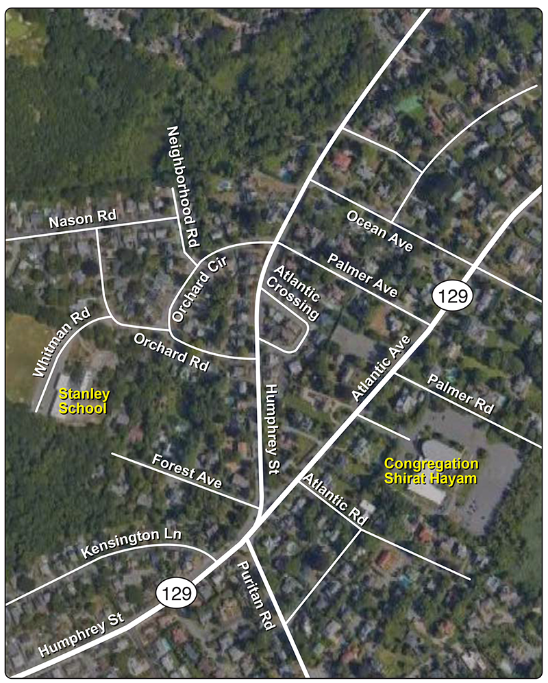
Swampscott—Study Area
TECHNICAL MEMORANDUM
DATE: July 5, 2024
TO: Marzie Galazka, Town of Swampscott
FROM: Kyle Casiglio, Boston Region MPO Staff
RE: Community Transportation Technical Assistance (CTTA) Program: Safer School Access Design in Swampscott
This memorandum describes the results of a transportation study of the approaches to Stanley Elementary School in Swampscott, Massachusetts. The study was conducted through the Boston Region Metropolitan Planning Organization’s (MPO) Community Transportation Technical Assistance (CTTA) Program, through which MPO staff provide technical analysis and support to municipalities in the Boston metropolitan area about local multimodal transportation issues.
The Town of Swampscott contacted Central Transportation Planning Staff (CTPS), the staff to the MPO, regarding the safety of approaches to Stanley Elementary School. Stanley Elementary is expanding into a consolidated school for Swampscott. A prior consultant-led traffic study estimated that the school could generate as many as 1,862 net new trips per day at full capacity. The Town requested that MPO staff study the conditions at the approaches to the school and analyze alternative redesign concepts for the primary intersection in the study area: Humphrey Street, Atlantic Avenue, and Forest Avenue Extension. The Town also indicated that a nearby synagogue had agreed to allow parking for parents to “park-and-walk” students to school and asked that two routes between the school and the synagogue be evaluated for safety.
MPO staff conducted community engagement and collected data in order to perform this analysis. We first conducted a site visit and met with Town staff. Additionally, we analyzed traffic counts, turning movement counts, speed data, and crash records to assess the concerns at the primary intersection. Then we reviewed the submitted redesigns and developed recommendations.
Recommendations included in this memorandum focus on improving safety for all road users by reducing high-speed traffic, providing safe facilities for pedestrians and bicyclists, and reducing risky merging and turn maneuvers. We provide short-term recommendations that can be implemented quickly (such as crosswalk striping, wayfinding signage, and quick-build safety infrastructure) along with longer-term recommendations (such as intersection reconstruction and raised crosswalks) that might need more time to operationalize but can be just as effective in improving safety, if not more.
The study area (see Figure 1) is located in the Town of Swampscott, which is a member of the North Shore Task Force (NSTF) subregion in the Boston metropolitan area. Swampscott is a coastal suburban community, bordered by the City of Lynn, City of Salem, and Town of Marblehead. The population of Swampscott is 15,125, based on the five-year 2018-2022 American Community Survey (ACS) estimates.
Figure 1
Swampscott—Study Area
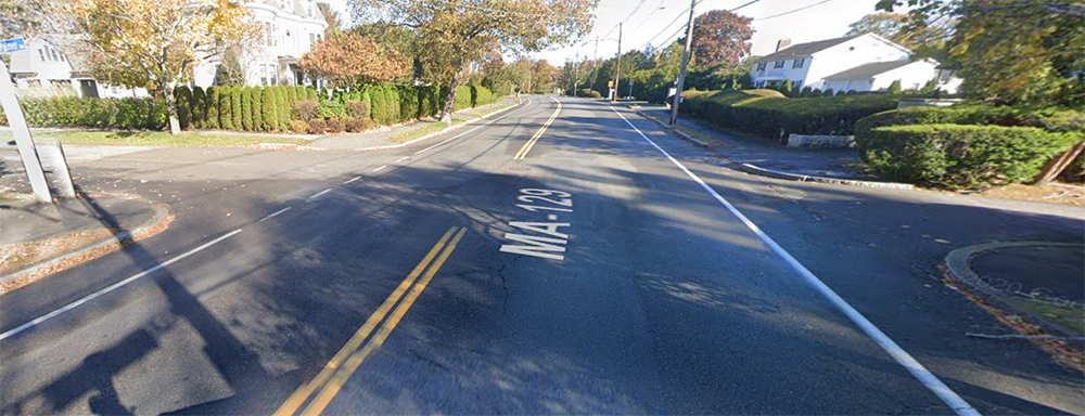
The study area features two primary roads, Humphrey Street and Atlantic Avenue. Both roads are parts of State Route 129 (SR129). The two roads meet at a Y-shaped intersection. West of the intersection, SR129 is Humphrey Street and connects the study area with downtown Swampscott to the south. Humphrey Street continues north of the intersection and serves as the primary road for accessing Stanley Elementary School. East of the intersection, SR129 travels along Atlantic Avenue, which facilitates connectivity between Swampscott and Marblehead to the north and connects the study area with downtown Swampscott to the south. Congregation Shirat Hayam, the location identified for the “park-and-walk,” is located on Atlantic Avenue. Forest Avenue Extension is a minor residential dead-end street that connects to the intersection. Fewer than 100 cars use the street daily (on average).
Traffic controls at the intersection include a yield sign for people entering the intersection from the southbound Humphrey Street approach, and a channelized slip lane for people entering from Atlantic Avenue and turning right onto Humphrey Street northbound. The nearest pedestrian crossing to the primary intersection is approximately 200 meters west of the intersection, on the far side of the nearby intersection of Humphrey Street and Puritan Road.
Town of Swampscott staff reported that pedestrian improvements had recently been implemented at the northern approaches to the school at Orchard Road and Orchard Circle, including high-visibility crosswalks, curb bump-outs, and a rectangular rapid flashing beacon (RRFB) at the intersection of Orchard Circle, Humphrey Street, and Palmer Avenue. At the northern boundary of the study area, they anticipate that the Swampscott Rail Trail will be extended along the historic rail right-of-way and will connect to the study area at Neighborhood Road.
The Massachusetts Bay Transportation Authority (MBTA) has one bus route with three stops in the study area: the Route 442 bus runs north-south on Humphrey Street and connects the study area with Lynn and the rapid transit system at Wonderland Station to the south as well as Marblehead to the north.
MPO staff met with Marzie Galazka, Director of Community and Economic Development, and Gino Cresta, Director of the Department of Public Works, from the Town of Swampscott on Thursday, March 7, 2024. Ms. Galazka outlined the concerns the Town had with the primary intersection and shared the park-and-walk concept that the Town had developed. Ms. Galazka and Mr. Cresta coordinated between municipal and MPO staff to arrange a site visit.
MPO staff met with Ms. Galazka, Mr. Cresta, and representatives from the Town of Swampscott school district on Monday, March 11, 2024. The visit took place from 2:00 PM to 3:30 PM and began at the primary intersection, with attendees walking through the study area. The route went up Atlantic Avenue to the Congregation Shirat Hayam parking lot, then continued up Atlantic Avenue to Palmer Avenue. We crossed Humphrey Street and continued to Stanley School via Orchard Circle, Orchard Road, and Whitman Road. Construction staff escorted the group through the site, following which we returned to the primary intersection via Forest Avenue Extension.
We took photographs and recorded videos of existing conditions and observed drivers utilizing each intersection along the walk. During the visit, MPO staff spoke with Town staff about their issues and concerns related to the study area and compared the pedestrian experience along both proposed park-and-walk routes.
MPO staff observed and noted existing infrastructure conditions throughout the study area, which are listed below:
Figure 2
Obstructed View of Atlantic Avenue from Humphrey Street Southbound
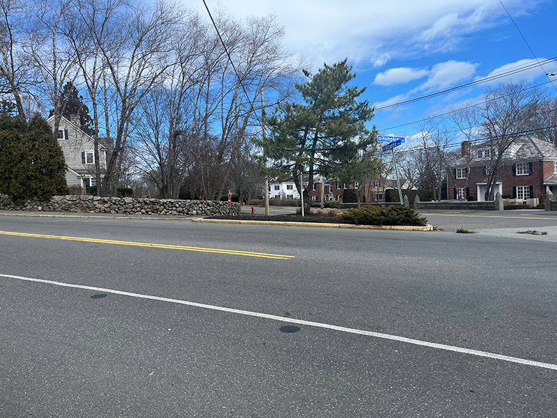
Source: Boston Region MPO staff.
Figure 3
Lack of Pedestrian Facilities at Primary Intersection
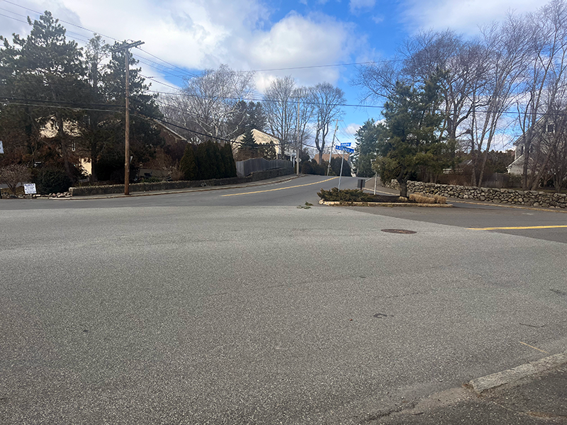
Source: Boston Region MPO staff.
Figure 4A
Lack of Pedestrian Facilities at Atlantic Avenue at Palmer Road
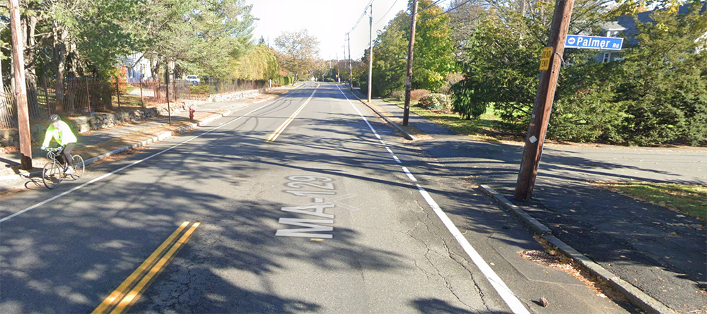
Source: Google Street View (November 2021).
Figure 4B
Lack of Pedestrian Facilities at Atlantic Avenue at Palmer Avenue
Source: Google Street View (November 2021).
Figure 4C
Pedestrian Facilities on One Side of Palmer Avenue at Humphrey Street
Source: Google Street View (November 2021).
Figure 5
Atlantic Avenue Bike Lanes
Source: Boston Region MPO staff.
Figure 6
Resident Posted Speed Sign
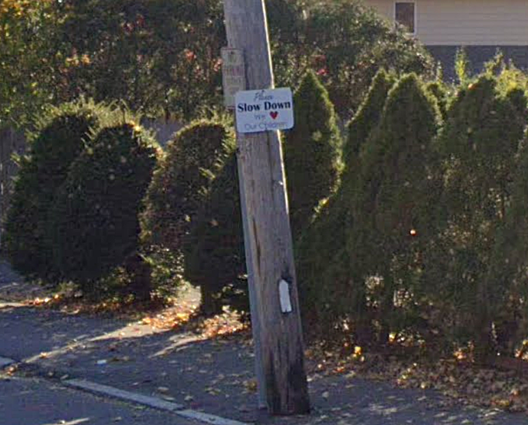
Source: Google Street View (November 2021).
MPO staff held an intermediate presentation on May 15, 2024, for Swampscott staff, attended by Ms. Galazka, Mr. Cresta, and Max Kasper, the Town’s Facilities Director. We shared our preliminary findings and recommendations based on the site visit and data collection effort described in Section 3. Swampscott staff requested that we include cost estimates in the alternatives analysis and an executive summary of findings to support a grant application for work within the study area. This executive summary was provided to the Town of Swampscott on May 30, 2024.
To examine the existing conditions, MPO staff collected automatic traffic recorder (ATR) counts on the approaching roadways for the primary intersection and turning movement counts (TMCs) for eight intersections in the study area. The ATR counts were recorded during March 4–8, 2024 (Monday–Friday). The TMCs were collected on Thursday, March 7, 2024, during three distinct time periods: the morning peak period (6:00 AM–9:00 AM), afternoon peak period (11:00 AM–2:00PM), and evening peak period (3:00 PM–6:00 PM).
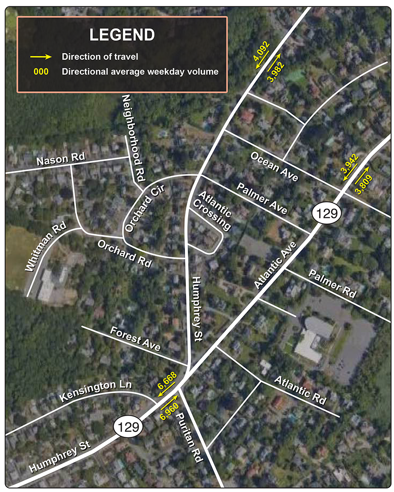
Figure 7 below summarizes the average annual weekday traffic volumes for the approaches to the primary intersection. Based on the data, staff calculated the average weekday traffic volumes in roadway sections near the primary intersection as follows:
Full ATR count data can be found in Appendix A of this memo.
Figure 7
Swampscott—Average Annual Daily Traffic (AADT)
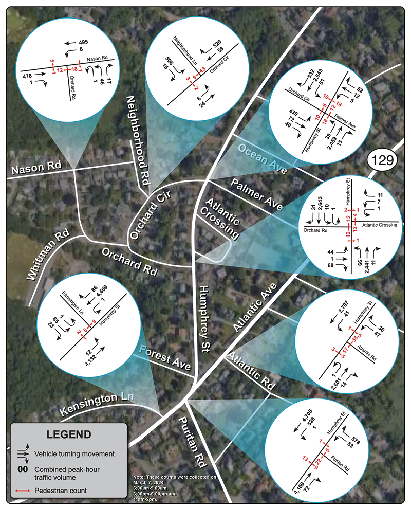
MPO staff collected turning movement counts at the study intersections on Thursday, March 7, 2024, during three distinct time periods: the morning peak period (6:00 AM–9:00 AM), afternoon peak period (11:00 AM–2:00 PM), and evening peak period (3:00 PM–6:00 PM). Figure 8 summarizes the TMCs collected on March 7, 2024, for these three periods within the primary intersection. Figure 9 summarizes the peak hour TMCs for secondary intersections within the study area. Original TMC count diagrams can be found in Appendix B of this memo.
Figure 8
Swampscott—Turning Movement Counts
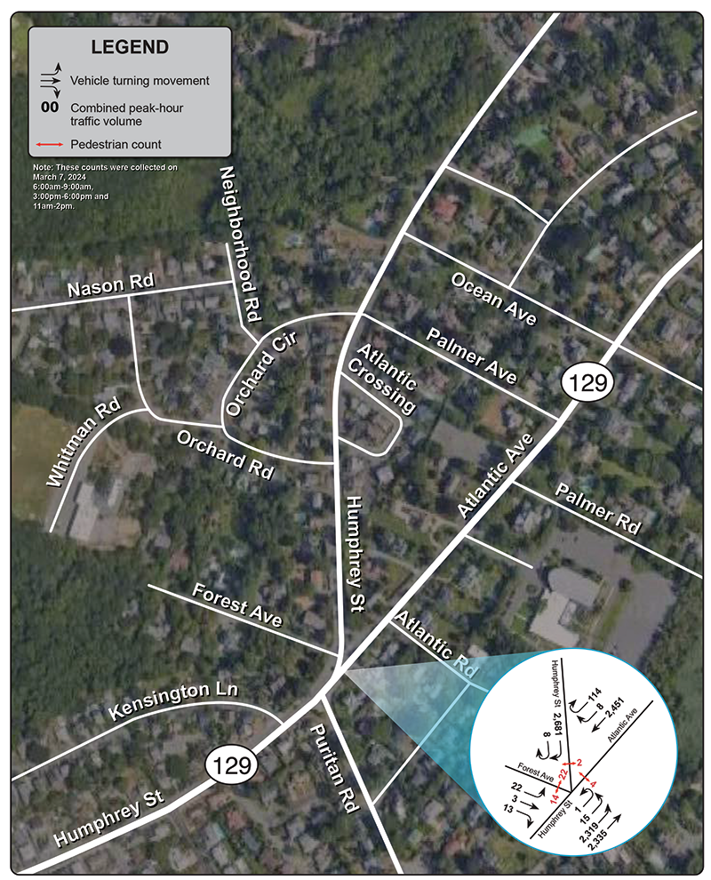
Figure 9
Swampscott—Turning Movement Counts
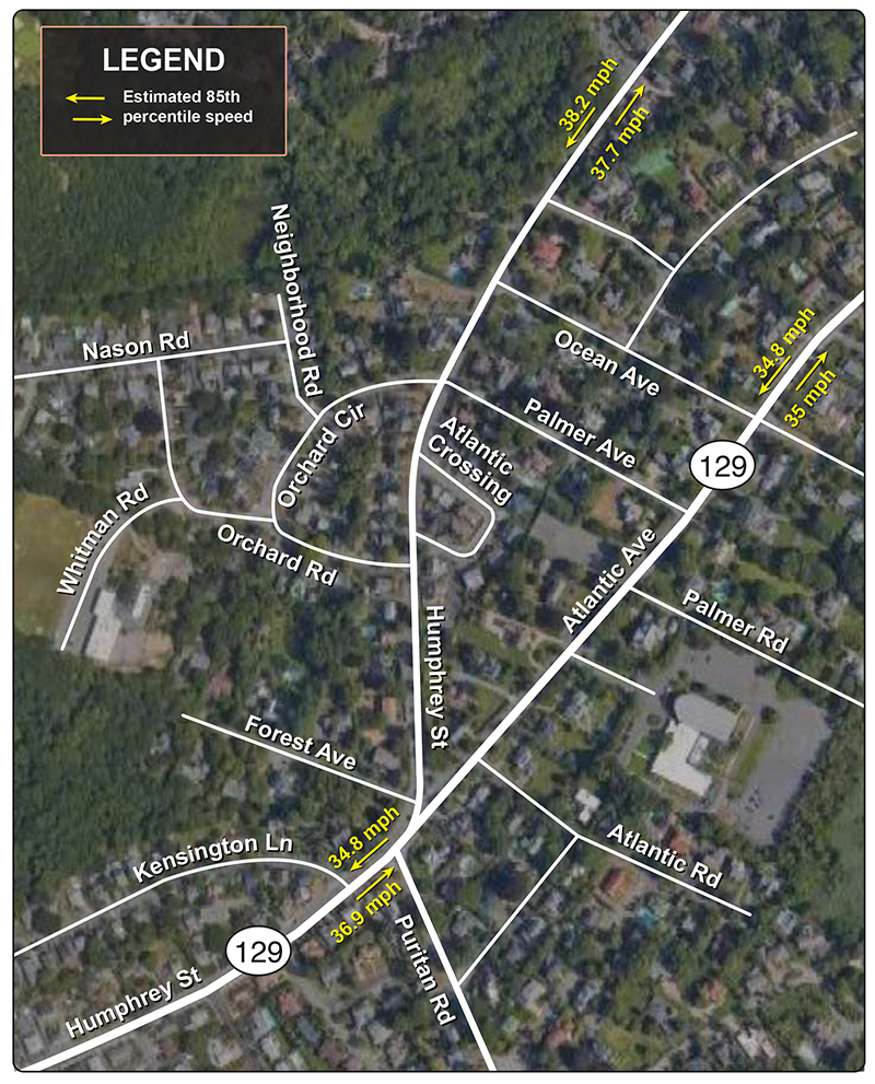
Along with total traffic counts, the ATR counts taken at the approaches to the primary intersection captured speed data. Figure 10 shows 85th percentile speed data for each of the approaches. All measured approaches have a speed limit of 30 mph, though a recommended 20 mph speed sign is posted on Humphrey Street for southbound drivers in advance of the yield. This recommended speed limit sign is located just to the south of where the ATR captured data for that segment.
All approaches to the intersection were measured as having an 85th percentile speed above the speed limit, ranging from 4.8 mph above the speed limit (westbound traffic on Atlantic Avenue and westbound traffic on Humphrey Street south of the intersection) to 8.2 mph above the speed limit (southbound traffic on Humphrey Street north of the intersection). Full speed data can be found in Appendix C of this memo.
Figure 10
Swampscott—Speed Measurements
MPO staff utilized the MassDOT IMPACT Crash Portal2 to determine the crash rate and number of crashes involving vulnerable road users3 within the study area over the five-year period from 2016–20. There were 33 crashes in the study area during the five-year period, representing 4.65 percent of all crashes in Swampscott over this period (771). Eight of these crashes resulted in someone getting injured and none resulted in fatalities. There was one crash involving a bicyclist, and none of the crashes involved a pedestrian.
Nineteen of the crashes occurred in the primary intersection, including the one crash involving a bicyclist. Thirteen of these crashes involved the yield traffic control for southbound drivers on Humphrey Street, resulting in rear-end collisions as people did not expect to stop (10 crashes) or in angle crashes from drivers proceeding through the yield too early (three crashes). The total of 19 crashes within this intersection exceeded the number of crashes at any other individual intersection in the Town of Swampscott during this period. Only one other intersection in Swampscott—where Eastman Avenue, Danvers Road, and Essex Street meet—had more than 15 crashes.
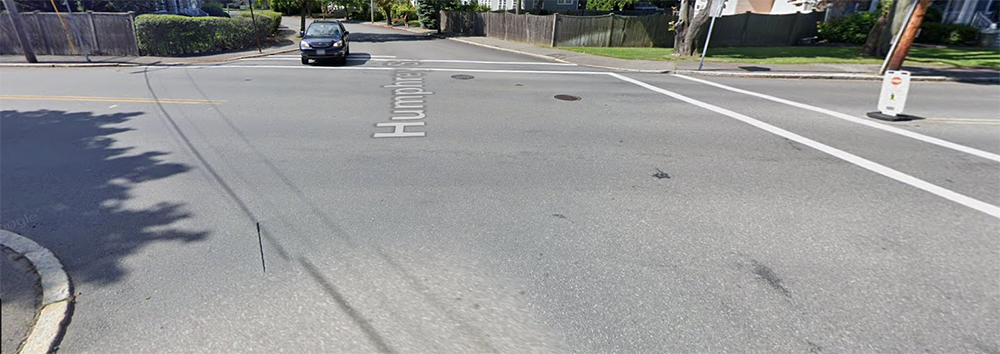
A second crash cluster was identified at the intersection of Humphrey Street, Palmer Avenue, and Orchard Circle. Five crashes occurred in this intersection during the five-year period.
The full crash data table can be found in Appendix D of this memo.
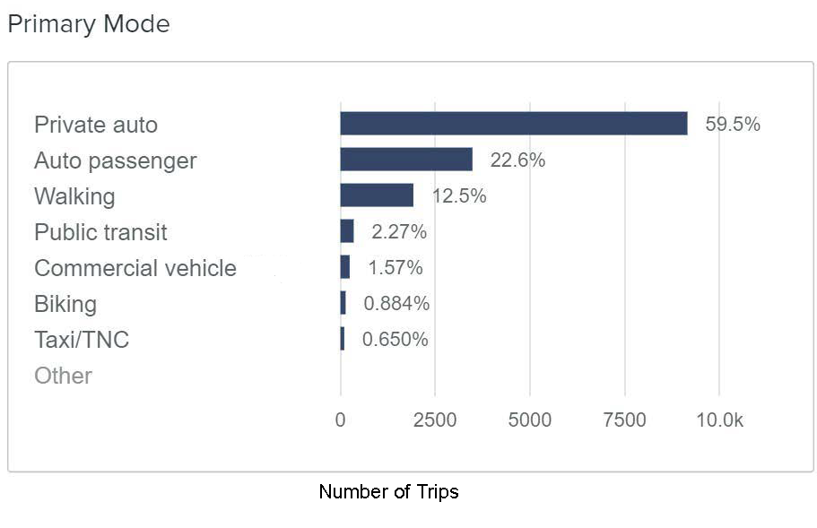
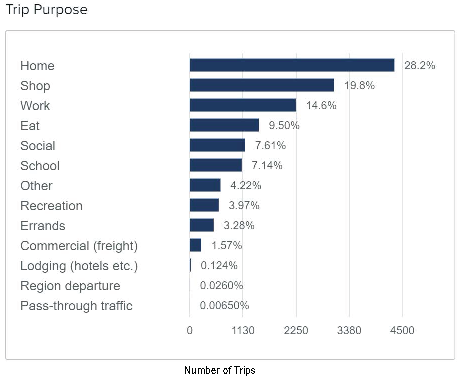
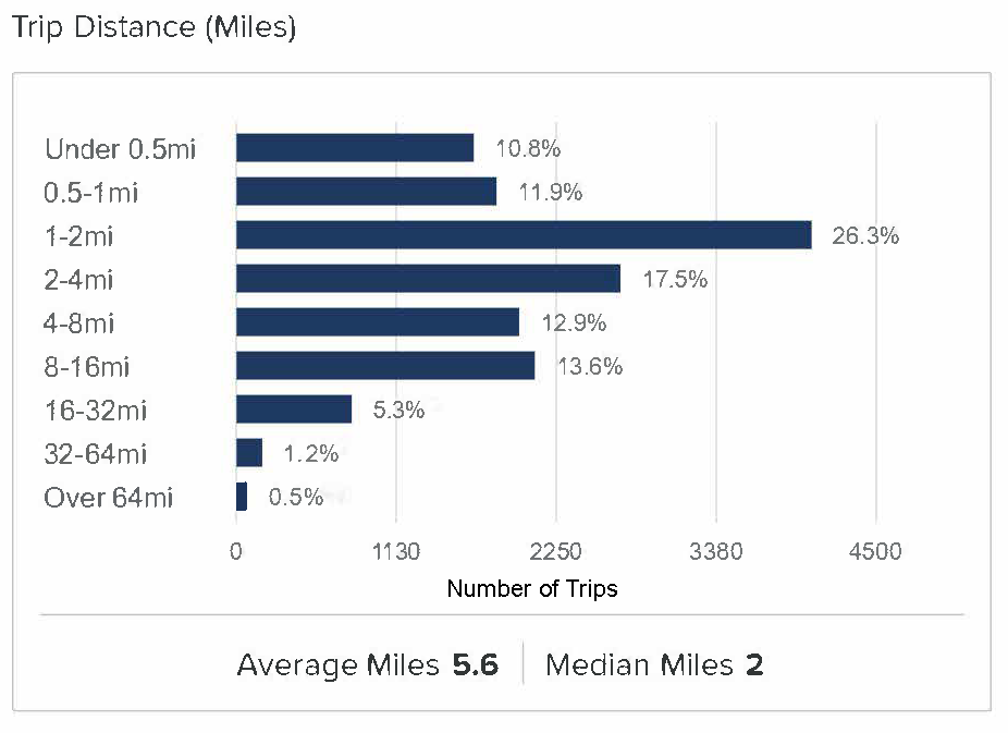
As the ATR counts were taken under winter conditions, MPO staff utilized Replica data to get a better understanding of pedestrian and bicyclist mode shares under fall conditions when the school would be opening. This analysis found that on a typical weekday in the fall of 2023, 15,400 trips by 8,620 trip-takers originated in the census tract referred to as MA-Essex County-2022, where the entirety of the study area lies. Walking was the primary mode of transportation in more than one in 10 trips (12.5 percent). However, fewer than one percent (0.88 percent) of trips were made by bicycling. The potential to increase walking trips is likely limited because only 10.8 percent of trips were shorter than half a mile, which is typically the median distance people walk for local trips. However, there appears to be significant room for growth in bicycling mode share because half of all trips (50.0 percent) were shorter than two miles. Figure 11 below summarizes the Replica data for the study area.
Figure 11
Fall 2023 Trip Origin Data for Census Tract MA-Essex County-2022
Town of Swampscott staff shared a traffic analysis study (TAS) performed by Greenman-Pederson, Inc. that assessed the impact the expanded school would have on traffic in the area and made recommendations to mitigate the impacts. The TAS found that under a full capacity scenario, the school would attract 1,862 additional daily trips compared to current conditions. Of these, 652 would be during the AM peak hour, when school would begin, and 616 would occur during the PM peak hour, when school lets out.
One of the recommendations included a revised traffic pattern for the residential streets north of the school to facilitate drop-off and pick-up of students. In this study, we assumed the revised traffic pattern to reflect future conditions.
After Greenman-Pederson conducted the TAS, the Town reached an agreement with the Congregation Shirat Hayam to allow parents to park their vehicles in the congregation’s parking lot and walk their students to school. Developing safe pedestrian routes between the parking lot and the school has the potential to alleviate some of the traffic congestion anticipated under future conditions.
Figure 12 below shows the revised traffic pattern recommended by the TAS. All of the streets shown presently allow bidirectional traffic. The revised pattern would develop a network of one-way streets in order to prevent parent drop-off and pick-up queues from backing up onto Humphrey Street. The TAS recommended using the width gained from removing one travel lane to provide bike lanes and expand sidewalks for vulnerable road users and to accommodate on-street parking. The revised traffic pattern would also prevent access to the school from the west, where vehicular traffic would only be allowed to exit, and from Forest Avenue Extension, which would only be open to buses, pedestrians, and bicyclists.
Figure 12
Revised Traffic Pattern Around Stanley School
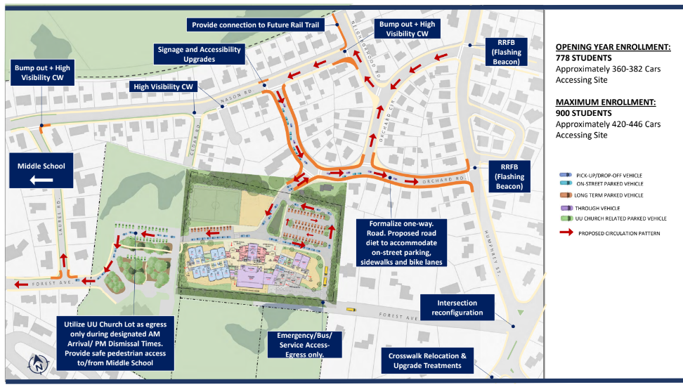
Source: Greenman-Pederson, Inc. Traffic Analysis Study.
As demonstrated earlier in Sections 3.3 and 3.4 of this memo, there are already considerable speeding and crash issues within the study area, particularly at the primary study intersection. Future conditions would not only add a significant number of trips to the study area, but they would also introduce a high number of pedestrians via the park-and-walk concept. Future conditions also presume a high percentage of the peak-hour trips will experience congestion on side streets associated with student pick-up and drop-off. This congestion could lead to increased aggressive driving behavior.
In the traffic analysis study shared by the Town of Swampscott, three conceptual redesigns were included for the primary intersection. MPO staff evaluated the pros and cons of each design. However, we did not select a preferred alternative due to the conceptual nature of the designs and room for revision.
Additionally, MPO staff evaluated the merits of the two proposed park-and-walk routes, with an emphasis on ability to implement them in time for the start of the 2024–25 school year. We recommend Alternative 2 as the preferred alternative for implementation for the 2024–25 school year, and Alternative 1 as a potential longer-term alternative if the primary intersection is reconstructed.
Design Alternative 1, shown below in Figure 13, would reconfigure the intersection into a single-lane roundabout, eliminating the slip lane and existing traffic controls.
MPO staff noted the following for Alternative 1:
Pros:
Cons:
Figure 13
Design Alternative 1: Roundabout Concept
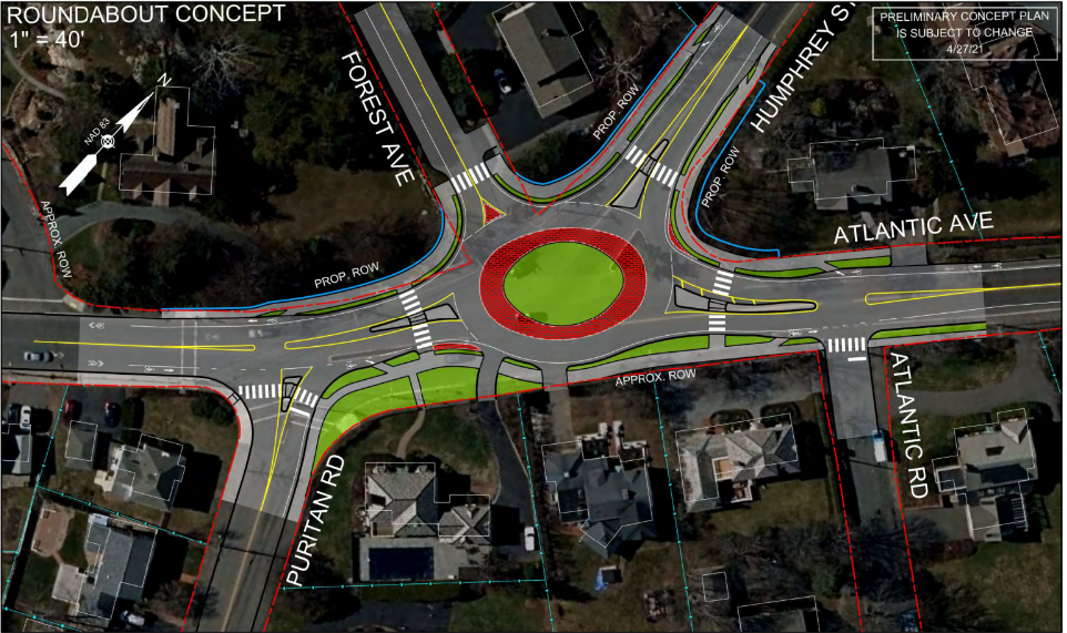
Source: Greenman-Pederson, Inc. Traffic Analysis Study.
Design Alternative 2, shown below in Figure 14, would reconfigure the intersection into a four-way signalized intersection.
MPO staff noted the following for Alternative 2:
Pros:
Cons:
Figure 14
Design Alternative 2: Signalized Concept
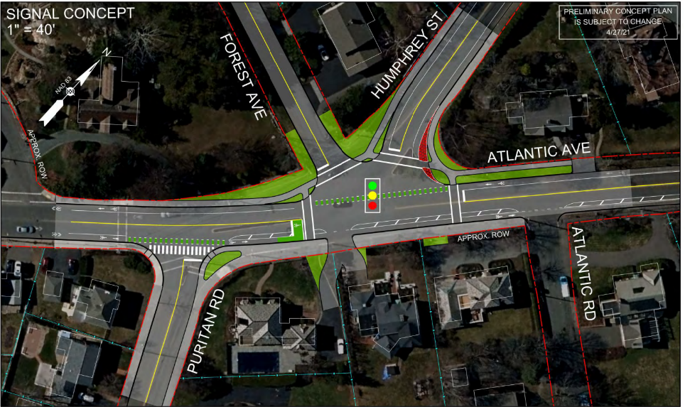
Source: Greenman-Pederson, Inc. Traffic Analysis Study.
Design Alternative 3, shown below in Figure 15, would reconfigure the intersection to direct Forest Avenue Extension traffic onto Humphrey Street and control what would then be a three-way intersection with a stop sign on Humphrey Street.
MPO staff noted the following for Alternative 3:
Pros:
Cons:
Figure 15
Design Alternative 3: Stop-Controlled Concept
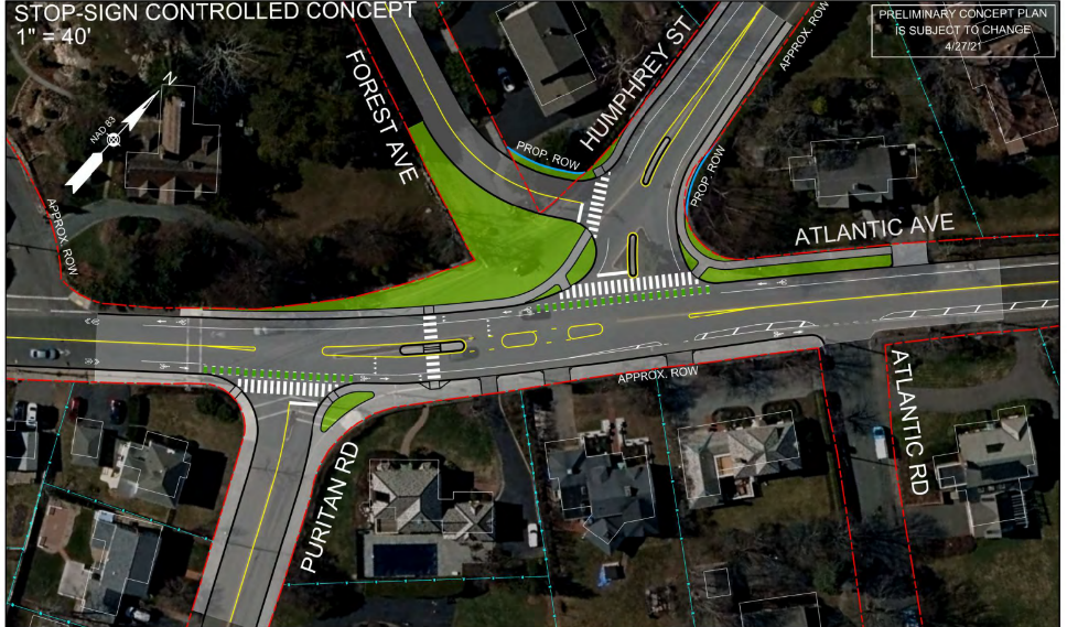
Source: Greenman-Pederson, Inc. Traffic Analysis Study.
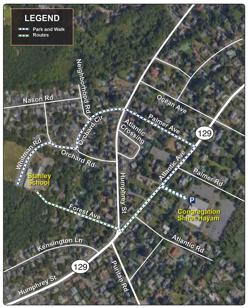
Figure 16 below shows the two park-and-walk alternatives under consideration. The route in Alternative 1 proceeds west on Atlantic Avenue until reaching the primary intersection, at which point students and parents would cross to Forest Avenue Extension to reach the school. The route in Alternative 2 proceeds east on Atlantic Avenue until reaching Palmer Avenue, where students and parents would cross and proceed to Humphrey Street. The route then crosses Humphrey Street and proceeds to the school via Orchard Circle and Orchard Road.
MPO staff noted the following for Alternative 1:
Pros:
Cons:
MPO Staff noted the following for Alternative 2:
Pros:
Cons:
As noted previously, MPO staff recommend Alternative 2 for short-term implementation for the 2024–25 school year. Alternative 1 may be a superior alternative in the longer term after reconstruction of the primary intersection.
Figure 16
Swampscott Park-and-Walk Routes
Through the analyses described in previous sections, MPO staff identified issues and concerns with current and future conditions and proposed short-term and longer-term improvements for the study area.
Our proposed short-term improvements would enhance safety and operations for the study area under existing and future conditions. We recommend that the Town of Swampscott implement the following improvements as soon as possible for the safety of all road users in the study area, especially the children who will begin attending Stanley Elementary in the fall of 2024:
In addition to the above recommendations, MPO staff recommend the Town work to further study and implement some of the following longer-term changes:
The Town of Swampscott approached the Boston Region MPO staff with concerns about the approaches to the expanded Stanley School and the expected increase in the number of trips attracted to the site. We used a combination of community outreach and multimodal data analysis to understand existing and projected future conditions, which allowed us to identify safety concerns related to speeding and high crash rates. To address these concerns, we developed short- and long-term recommendations and we analyzed alternative reconstruction concepts for the primary intersection, providing feedback on the three ideas. Finally, we assessed safety and comfort along two alternative park-and-walk routes and recommended Alternative 2 as the preferred route.
Funding for the implementation of these recommendations in the short term can be sought from the Massachusetts Safe Routes to School program7 and the MPO’s Transportation Improvement Program (TIP).8 Specifically, the Community Connections Program within the TIP is a relevant funding source for projects that enhance bicycle and pedestrian safety such as those included in these recommendations.
The opening of Stanley School presents a unique opportunity to make the surrounding area in Swampscott safer and more accessible for walking and biking. Active commute modes improve self-reported well-being9 and reduce barriers to upward mobility.10 Students, parents, and the community around the school will benefit from the increased opportunities for active mobility in their town. These interventions can have long lasting impacts on the travel patterns of Swampscott students. Young children who walk or bike to school are more likely to continue the habit as they age.11 Investing in safe pedestrian and bicycling routes to Stanley School is thus an investment in driving long-term mode shift and in the well-being of Swampscott’s youth.
Appendix B TMC Diagrams
Appendix C Speed Data
Appendix D Crash Data
1 Level of traffic stress (LTS) is a rating given to a road segment or crossing indicating the stress it imposes on bicyclists. See https://peterfurth.sites.northeastern.edu/level-of-traffic-stress/, last accessed June 20, 2024.
2 See https://apps.impact.dot.state.ma.us/cdv/, last accessed May 7, 2024.
3 In Massachusetts, vulnerable road users include people walking and biking; roadside workers; people using mobility devices such as wheelchairs, motorized bicycles, scooters, skateboards, roller skates, and other micromobility devices; and people riding horses and driving horse-drawn carriages and farm equipment. See https://www.massbike.org/new-massachusetts-vulnerable-road-users-laws-webinar-recap-faq.
4 See https://mutcd.fhwa.dot.gov/pdfs/2003/Ch2B.pdf, last accessed June 22, 2024.
5 See https://bicycledutch.wordpress.com/2015/10/13/explaining-the-dutch-roundabout-abroad/, last accessed on May 13, 2024.
6 See https://lrrb.org/media/reports/TRS1413.pdf, last accessed on May 13, 2024.
7 See https://www.mass.gov/safe-routes-to-school , last accessed June 22, 2024.
8 See https://www.ctps.org/tip, last accessed June 22, 2024.
9 See https://www.sciencedirect.com/science/article/abs/pii/S2214140516302407, last accessed June 22, 2024.
10 See https://psycnet.apa.org/record/2018-63708-001, last accessed July 2, 2024.
11 See https://www.sciencedirect.com/science/article/pii/S2211335522000250/, last accessed July 2, 2024.