
Technical Memorandum
DATE: May 6, 2021
TO: James Marsh, City of Lynn
FROM: Casey Claude, Boston Region Metropolitan Planning Organization Staff
RE: Locations with High Bicycle and Pedestrian Crash Rates in the Boston Region Metropolitan Planning Organization (MPO) Area: Liberty Street and Washington Street in Lynn
This memorandum summarizes the analyses and improvement strategies for the intersection of Liberty Street and Washington Street in Lynn.
This memorandum contains the following sections:
It also includes technical appendices that contain data and methods applied in the study.
The purpose of the Locations with High Bicycle and Pedestrian Crash Rates in the Boston Region MPO Area study is to examine safety, mobility, and comfort issues for bicycle and pedestrian travel at intersections in the Boston region. The intent of the study is twofold: (1) study high-crash locations to understand what is contributing to the danger of walking and bicycling at selected intersections, and (2) identify features of the physical environment in need of improvement for the safety and comfort of pedestrian and bicycle travel. This work gives the communities in which the intersections are located the opportunity to look at the needs of the studied intersections, starting at the conceptual level, before the municipality commits funds for design and engineering. Eventually, if the project qualifies for federal funds, the study’s documentation also is useful to the Massachusetts Department of Transportation (MassDOT). This study supports the MPO’s visions and goals, which include increasing transportation safety, maintaining the transportation system, advancing mobility, and reducing vehicle emissions.
Following a selection process based on bicycle and pedestrian crash information, equity considerations, and implementation potential, the following three locations were chosen for study:
The location in Lynn was selected because the intersection at Liberty Street and Washington Street is located within Highway Safety Improvement Program (HSIP) crash clusters for both bicyclists and pedestrians.1 The intersection also is located within a transportation analysis zone (TAZ) that exceeds the regional thresholds for minority and low-income populations. 2
MPO staff discussed safety and operations issues at the intersection and the scope of work for the study with staff of the City of Lynn, who expressed interest and willingness to participate in the study. The intersection is heavily used as a connection in downtown Lynn from Market Street to Essex Street. Safe bicycle and pedestrian facilities at the intersection are particularly important due to the location’s proximity to the YMCA, Saint Mary’s High School, and a proposed shared-use path that would connect the terminus of the planned Northern Strand Community Path at 756 Western Avenue to the Lynn Shore and Nahant Beach Reservation.
The Northern Strand Community Path will split into two separate trails at the Western Avenue terminus. While the Community Path of Lynn will connect Western Avenue to Bennett Street by continuing along the abandoned trail bed that runs beside South Street, a separated on-road bicycle lane will travel down South Common Street into downtown Lynn along Market Street. Liberty Street intersects Market Street, so providing safe and comfortable bicycle accommodations along the roadway would expand Lynn’s bicycle network.
The City of Lynn recognizes the need to improve the intersection to ensure safe and comfortable travel for all users. Figure 1 shows the location of the intersection and the surrounding roadways.
Figure 1
Intersection Study Area
Liberty Street and Washington Street
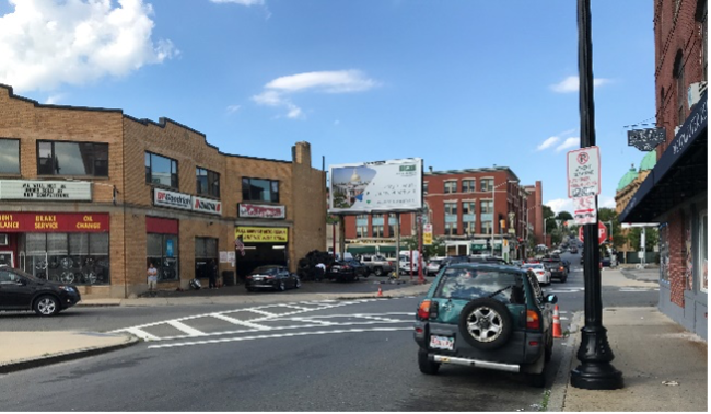
The intersection of Washington Street and Liberty Street is a four-legged, signalized intersection that is actuated with inductive loop detection.3 There are three approaches to the intersection. Liberty Street is a northbound, one-way road with a two-lane approach that includes a through/right lane and a left/through lane. Washington Street eastbound and westbound make up the intersection’s other two approaches. Washington Street eastbound has a two-lane approach with a through lane and a Left Turn Only lane, while westbound is a single-lane approach with a right/through lane.
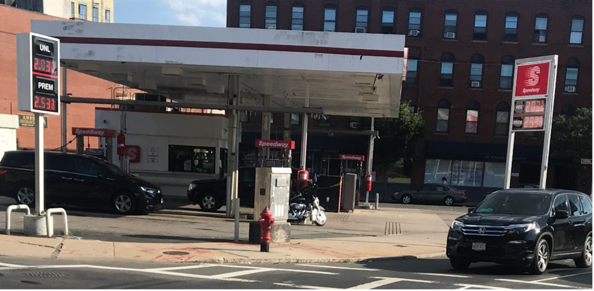
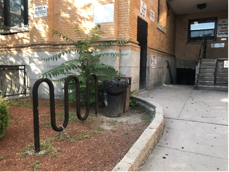
Off the southern corner of the intersection is a Speedway gas station. On the eastern side of the intersection is My Brother’s Table, the largest soup kitchen on the North Shore (Figure 2). The north of the intersection is anchored by a mixed-use building that includes a convenience store, the Lynn Shelter Association, and a Dominican restaurant (Figure 3). Directly west of the intersection are parking lots that serve offices and an auto repair shop along Central Street (Figure 4).
Figure 2
My Brother’s Table on East Corner of the Intersection of Liberty and Washington Streets
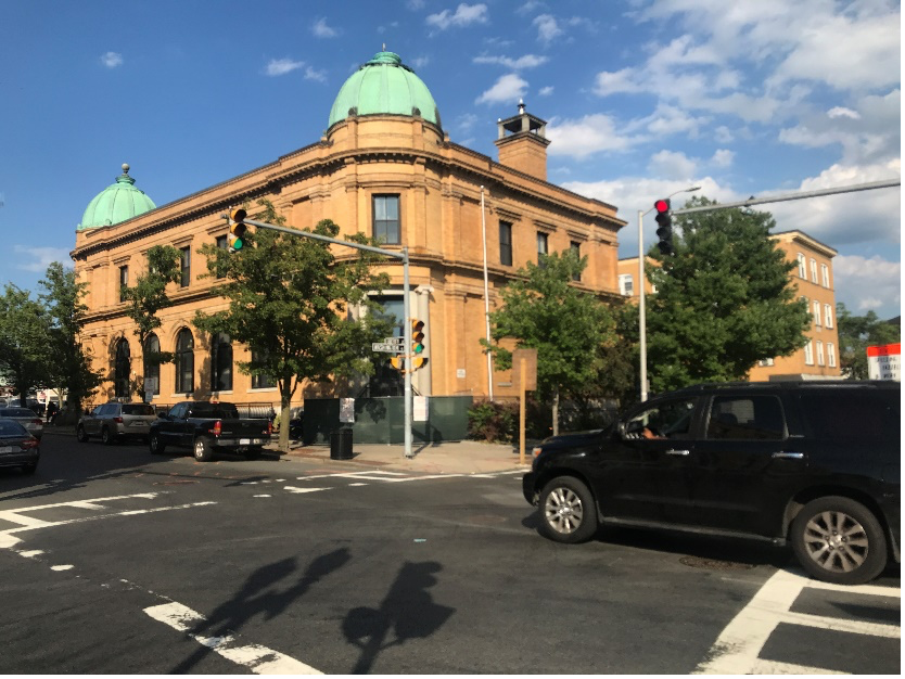

Figure 3
Mixed-Use Building on North Corner of the Intersection of Liberty and Washington Streets
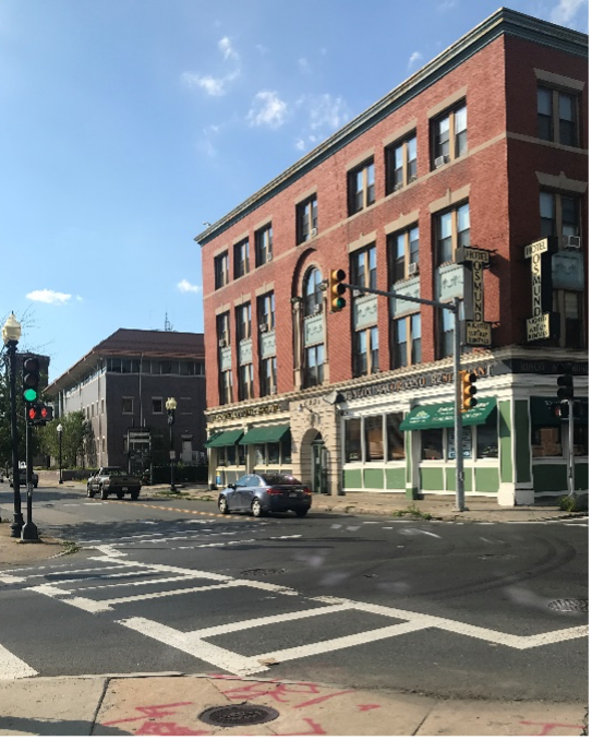
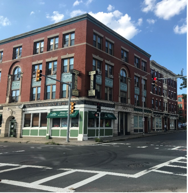
Figure 4
Parking Lot on Liberty Street on West Corner of the Intersection of Liberty and Washington Streets
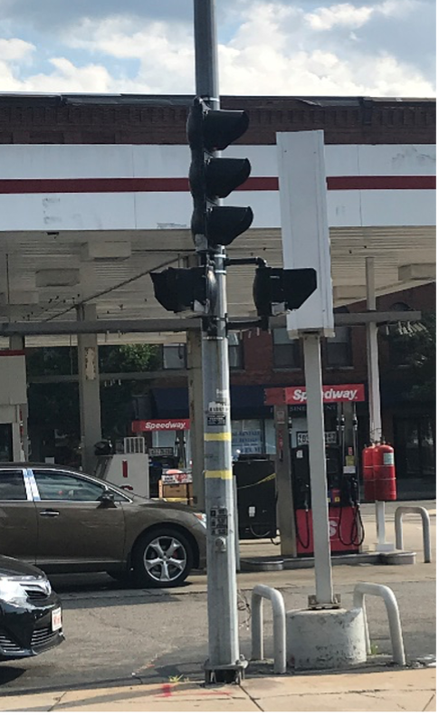
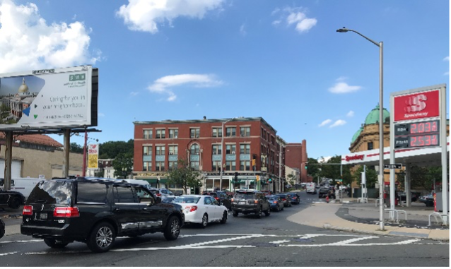
There are wide curb cuts present along both sides of Liberty Street to accommodate entering and exiting vehicles (Figure 5). On the west side of the roadway, the curb cuts serve the parking lots for the offices at 115-133 Central Avenue and the auto repair shop at 101 Central Avenue. On the east side of the roadway, the curb cuts serve the Speedway gas station on the south corner of the intersection (Figure 6), for which there are also curb cuts included on the southern side of Washington Street’s westbound approach.
Figure 5
Wide Curb Cuts on Liberty Street Intersection Approach
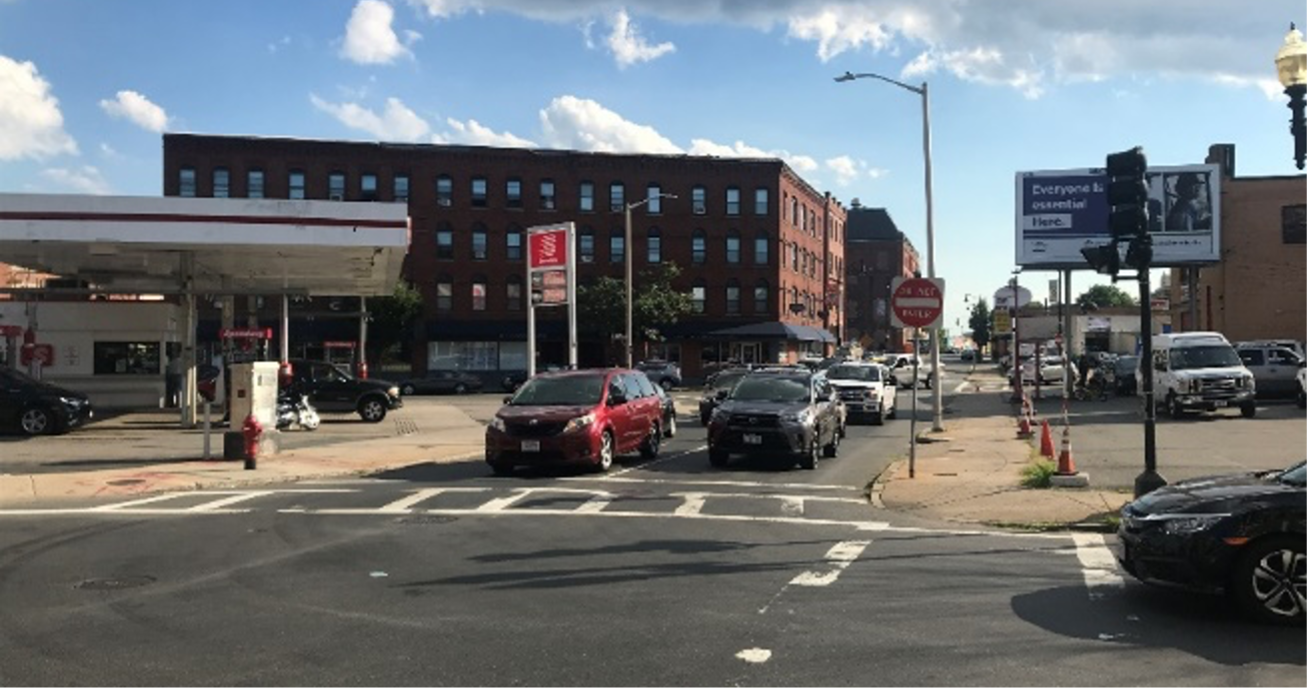
Figure 6
Speedway Gas Station on South Corner of the Intersection of Liberty and Washington Streets
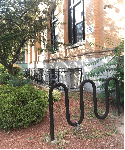
Sidewalks run along both sides of every approach to the intersection, all exceeding the American with Disabilities Act (ADA) minimum width of five feet. Fading ladder-style crosswalks mark each crossing with solid white lines between two parallel solid white lines. Apex curb ramps are located at each of the intersection’s four corners. There are no bicycle facilities along either roadway, although a wave bicycle rack is installed outside My Brother’s Table on the northern side of Washington Street’s westbound intersection approach (Figure 7).
Figure 7
Wave Bicycle Rack Installed at My Brother’s Table on Washington Street
The intersection’s exclusive pedestrian phase is push-button actuated. There are two one-section pedestrian signal heads at each corner. The signals on the eastern, southern, and western corners feature a nine-inch LED symbol display. The pedestrian signals on the northern corner feature a 12-inch LED symbol display and include countdown displays for the pedestrian Flashing Don’t Walk phase.
Within the vicinity of the study intersection, there are bus stops for MBTA bus Route 435. Route 435 buses travel outbound along Washington Street, with the nearest stop to the study intersection located at Washington Street and Essex Street, one block west of the intersection. Inbound buses on Route 435 travel along both Washington Street and Liberty Street, turning left up Liberty Street at the study intersection. The two nearest Route 435 bus stops along the inbound route are at Washington Street and Essex Street and at Liberty Street and Barker Court, approximately one block north of the intersection.
None of the intersection approaches feature on-street parking. North of the intersection, beside My Brother’s Table, there is signage for two-hour parking on the east side of Liberty Street.
Central Street meets Liberty Street just southwest of the Washington Street intersection under study. Central Street is an eastbound, one-way road with a one-lane approach and, on the block prior to Liberty Street, on-street parking on its north side. The intersection is non-signalized and skewed such that left turns onto Liberty Street are wide, with an acute angle view of oncoming traffic to the right. A mid-block crosswalk approximately 170 feet southeast of the intersection facilitates pedestrian travel across Washington Street.
The width of Liberty Street exceeds 26 feet from Sutton Street to beyond Willow Street, but is only striped for two lanes of motor vehicle traffic from Central Avenue to Washington Street. The width of Liberty Street exceeds 24 feet from Market Street to Sutton Street.
Street signage along Liberty Street from Market Street to Willow Street indicates that parking is not allowed on the northwest side of the roadway, aside from outside of Rossetti Restaurant, located at Liberty Street’s intersection with Sutton Street, where one-hour parking is permitted.
On the southeast side of Liberty Street, parking is not allowed near Market Street, but the area is a loading zone. Paid street parking is available on Liberty Street’s southeast side from Sutton Street to Central Avenue. Parking on Liberty Street’s southeast side is allowed for two hours between Washington Street and Willow Street.
MPO staff observed more vehicles turning into the Speedway parking lot than the Central Avenue parking lots, which suggests that the northwest side of Liberty Street is safer for bicycle travel than the southeast side of the roadway.
The biggest concern at the Liberty Street and Washington Street intersection is that it is located within HSIP crash clusters for both bicyclists and pedestrians. As previously explained, there are no bicycle facilities along either roadway. While there are pedestrian accommodations, such as sidewalks and pedestrian signals at the intersection, there are several elements in need of improvement.
Although there are curb ramps at all four corners of the Liberty Street and Washington Street intersection, they are all apex ramps, which direct users into the middle of the intersection.
All four curb ramps lack detectable warnings with truncated domes, which is an ADA requirement to help users with disabilities distinguish between the safety of the sidewalk and the danger of the roadway.
MPO staff observed several pedestrians crossing Washington Street southeast of Liberty Street, between the intersection and the mid-block crosswalk less than a block away.
The pedestrian signal push buttons at each corner are not Accessible Pedestrian Signals (APS), meaning they do not include a tactile or audible component to communicate to hearing- or vision-impaired users that it is safe to cross the intersection.
Two of the Liberty Street and Washington Street intersection’s pedestrian signals are not facing the proper direction. Both Washington Street crossings for southward travel along Liberty Street have a pedestrian signal facing east instead of north. Figures 8 and 9 below illustrate these conditions.
Figure 8
Pedestrian Signals on Western Corner of the Intersection of Liberty and Washington Streets
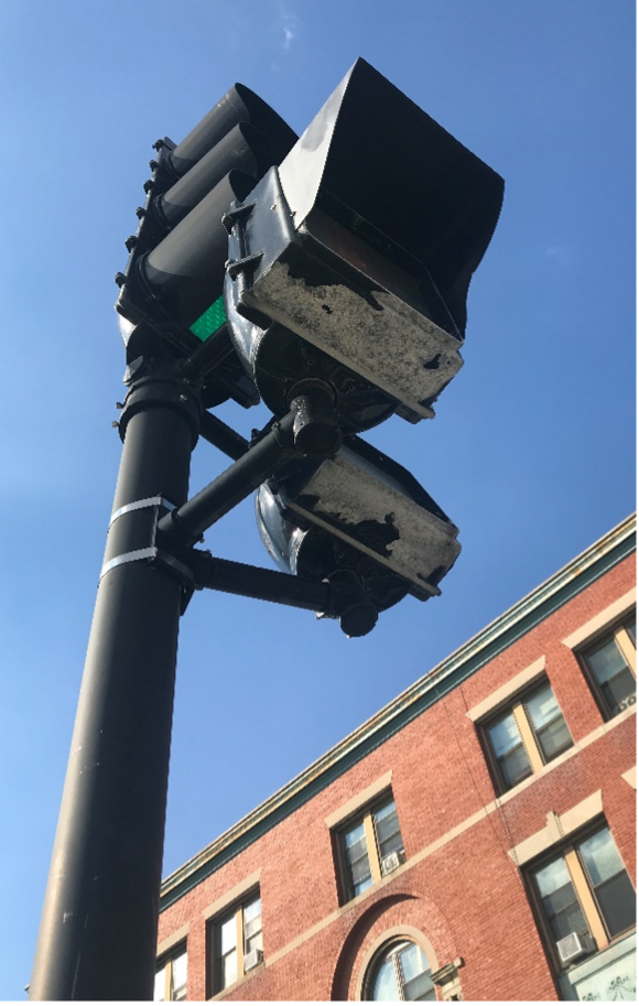
Figure 9
Pedestrian Signals on Southern Corner of the Intersection of Liberty and Washington Streets
The non-signalized intersection of Liberty Street and Central Street to the southwest of the study intersection presents concerns related to driver behavior during peak hours. Field observations suggest that the elevated volume of vehicles on both Liberty Street and Central Street during peak travel times leads motorists on Central Street to suddenly and quickly cross or turn onto Liberty Street when they perceive an opening in traffic. When the focus of drivers’ attention is directed to finding gaps in vehicle traffic, the opportunity for pedestrian or bicyclist conflicts with motorists increases because other road users become a secondary consideration for drivers when they are trying to gauge Liberty Street traffic.
Figure 10
View along Liberty Street with Central Street Approach on Left
The number of driveways and parking lots in the study area is a notable safety concern. Both sides of the Liberty Street approach along the southwest leg of the intersection have many points for conflict because vehicles cross the sidewalk to access the parking lots and the Speedway gas station. Another entrance to the gas station is on Washington Street on the southeastern leg of the intersection, which introduces conflict potential along the sidewalk on the southwestern side of the street.
On July 29, 2020, MPO staff counted 92 pedestrians and 15 bicyclists during one hour of peak travel. Staff observed pedestrians in the roadway along Washington Street’s southeastern approach to the intersection and along Liberty Street northeast of the intersection. Many bicyclists observed at the intersection were traveling along the sidewalks.
MPO staff graded the intersection of Liberty Street and Washington Street in Lynn using the Boston Region MPO’s Pedestrian Report Card Assessment (PRCA)4 and Bicycle Report Card5 tools to assess the safety and comfort of the area for people walking and bicycling. The grading categories reflect the MPO’s Long Range Transportation Plan (LRTP) goals and assess the quality of four different aspects of the environment associated with these goal areas: Capacity Management and Mobility, Economic Vitality, Safety, and System Preservation. The report cards also prioritize locations based on Transportation Equity factors, incorporating another Boston region LRTP goal.
Figure 11
Non-Signalized Intersection PRCA for Liberty Street and Washington Street
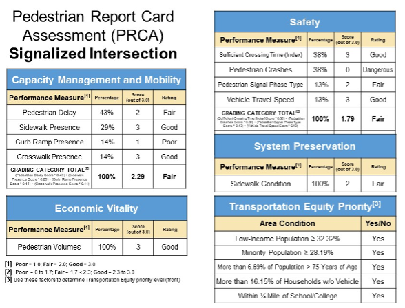
The intersection received a “Fair” score for Capacity Management and Mobility. The lack of paired curb ramps and the complete absence of detectable warnings featuring truncated domes lowered the category score, while the presence of marked crosswalks across every leg and sufficiently wide sidewalks along both sides of the two roadways improved the overall grade. The current pedestrian delay, which is the amount of time a pedestrian waits in the signal cycle for the pedestrian crossing phase, of approximately 31 seconds is decent but could be improved.
The intersection scored well for pedestrians in the Economic Vitality category because many pedestrians travel through the location.
The intersection of Liberty Street and Washington Street earned a “fair” Safety score in spite of its location in an HSIP-eligible crash cluster for three reasons. The first is that the pedestrian crossing phase is exclusive, which is helpful because it separates pedestrians crossing the intersection from vehicle traffic. However, exclusive signals often result in increased pedestrian delay due to the lack of frequency of the pedestrian phase within the signal cycle. Therefore, the intersection earned a “fair” rating for the Pedestrian Signal Phase Type metric. The intersection earned a “good” grade for the amount of time provided for pedestrians to cross the intersection because it allows pedestrians to travel at a speed of 2.39 feet per second, which is approximately 68 percent of the Federal Highway Administration (FHWA) maximum crossing speed of 3.5 feet per second. This guidance aims to provide sufficient time for all users to complete an intersection crossing. Vehicle travel speed is considered “good” at the intersection of Liberty Street and Washington Street because the average does not exceed 25 miles per hour.
Sidewalk condition is “fair” at the location because many segments of concrete are cracked and in need of repair, but the sidewalks themselves are of sufficient width and located on both sides of all four intersection legs. Finally, the intersection is considered a high priority area for pedestrian transportation equity because the proportions of all four populations of concern (low income, minority, elderly, and zero vehicle households) at the location exceed their regional averages and the intersection is located within a quarter mile of a school.
Figure 12
Bicycle Report Card for Liberty Street and Washington Street
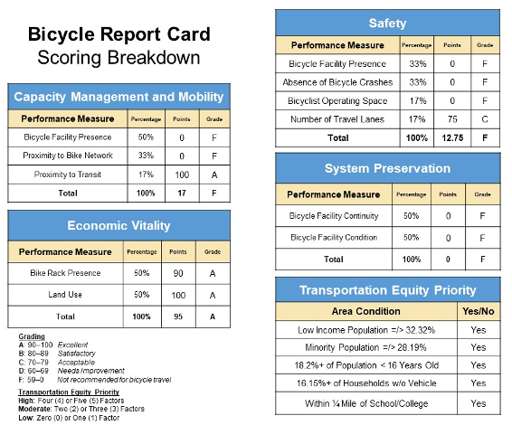
The intersection of Liberty Street and Washington Street received a failing score for three out of four Bicycle Report Card grading categories. The lack of bicycle facilities played a large factor in the ratings. In the Capacity Management and Mobility category, this absence—combined with the lack of bicycle facilities within a quarter mile of the location—outweighed the fact that the Route 435 bus stop is one block away from the study location, much closer than the half mile Proximity to Transit metric.
In the Economic Vitality category, however, the presence of sub-par bike racks had value in supporting access to the businesses and services at this intersection with its diverse land uses, which create many origins and destinations for bicyclists within the study area.
Although the southeast side of Washington Street only includes one lane of traffic per direction of travel, Washington Street’s southeast-bound approach features two lanes of travel in one direction and both sides of Liberty Street include two one-way lanes for motorists. This allowed the intersection to barely pass the Number of Travel Lanes performance metric, but the intersection failed the remaining three metrics included in the Safety category of the Bicycle Report Card. The lack of bicycle facilities at the intersection, the associated absence of bicyclist operating space along both roadways, and the fact that Chestnut Street meets Everett Avenue within an HSIP-eligible bicycle crash cluster all contribute to the location’s failing Safety score.
Without bicycle facilities at the location, it was impossible for either roadway to earn points for bicycle System Preservation, which led to another failing grade. Finally, the intersection is considered a high priority area for pedestrian transportation equity because the proportions of all four populations of concern (low income, minority, youth, and zero vehicle households) at the location exceed their regional averages and the intersection is located within a quarter mile of a school.
Forty crashes were recorded over the five-year period between 2013 and 2017. Table 1 breaks these crashes down by the type of collision, severity, and factors that may have influenced the crash. Eight crashes involved pedestrians and one involved a bicyclist. The majority of the pedestrian and bicycle crashes occurred under dry conditions during off-peak travel hours.
| Table 1 |
||||
|---|---|---|---|---|
| 2013–17 Crash Summary Table |
||||
| Crash Variable |
Number of Total Crashes |
Number of Vehicle Only Crashes |
Number of Pedestrian-Involved Crashes |
Number of Bicyclist-Involved Crashes |
| Crash Severity |
-- |
-- |
-- |
-- |
| Non-fatal injury |
15 |
8 |
7 |
0 |
| Property damage only |
22 |
20 |
1 |
1 |
| Not reported |
3 |
3 |
0 |
0 |
| Total crashes |
40 |
31 |
8 |
1 |
| Manner of Collision |
-- |
-- |
-- |
-- |
| Angle |
13 |
11 |
2 |
0 |
| Rear-end |
10 |
10 |
0 |
0 |
| Sideswipe, opposite direction |
1 |
1 |
0 |
0 |
| Sideswipe, same direction |
5 |
4 |
1 |
0 |
| Head-on |
1 |
1 |
0 |
0 |
| Single vehicle crash |
7 |
1 |
5 |
1 |
| Not reported/unknown |
3 |
3 |
0 |
0 |
| Total Crashes |
40 |
31 |
8 |
1 |
| Road Surface Condition |
-- |
-- |
-- |
-- |
| Dry |
29 |
22 |
6 |
1 |
| Snow |
2 |
2 |
0 |
0 |
| Wet |
8 |
6 |
2 |
0 |
| Not reported |
1 |
1 |
0 |
0 |
| Total Crashes |
40 |
31 |
8 |
1 |
| Ambient Light Condition |
-- |
-- |
-- |
-- |
| Dawn |
1 |
0 |
1 |
0 |
| Daylight |
22 |
17 |
4 |
1 |
| Dusk |
4 |
3 |
1 |
0 |
| Dark - lighted roadway |
13 |
11 |
2 |
0 |
| Total Crashes |
40 |
31 |
8 |
1 |
| Weather Condition |
-- |
-- |
-- |
-- |
| Clear |
25 |
20 |
4 |
1 |
| Wind/severe crosswind |
1 |
1 |
0 |
0 |
| Cloudy |
5 |
3 |
2 |
0 |
| Rain |
5 |
3 |
2 |
0 |
| Sleet |
2 |
2 |
0 |
0 |
| Snow |
2 |
2 |
0 |
0 |
| Total Crashes |
40 |
31 |
8 |
1 |
| Travel Period |
-- |
-- |
-- |
-- |
| Peak AM |
9 |
6 |
2 |
1 |
| Peak PM |
4 |
3 |
1 |
0 |
| Off-peak |
27 |
22 |
5 |
0 |
| Total Crashes |
40 |
31 |
8 |
1 |
| Five-Year Average |
8 |
6.2 |
1.6 |
0.2 |
* Peak periods are defined as 6:00–9:00 AM and 3:00–6:00 PM
Some highlights from the data include the following:
MPO staff also prepared a collision diagram for the study intersection to examine crash patterns. Police reports were obtained for the years 2013–17. Figure 11 shows the collision diagram. The index numbers in the collision diagram may be used to cross-reference the crash records in Appendix B. The index numbers with circles around them refer to crashes that resulted in injury or fatality, and the severity is depicted by the thickness of the circle line.
Figure 13
Collision Diagram: MassDOT Crash Data 2013-17
Liberty Street and Washington Street Intersection in Lynn
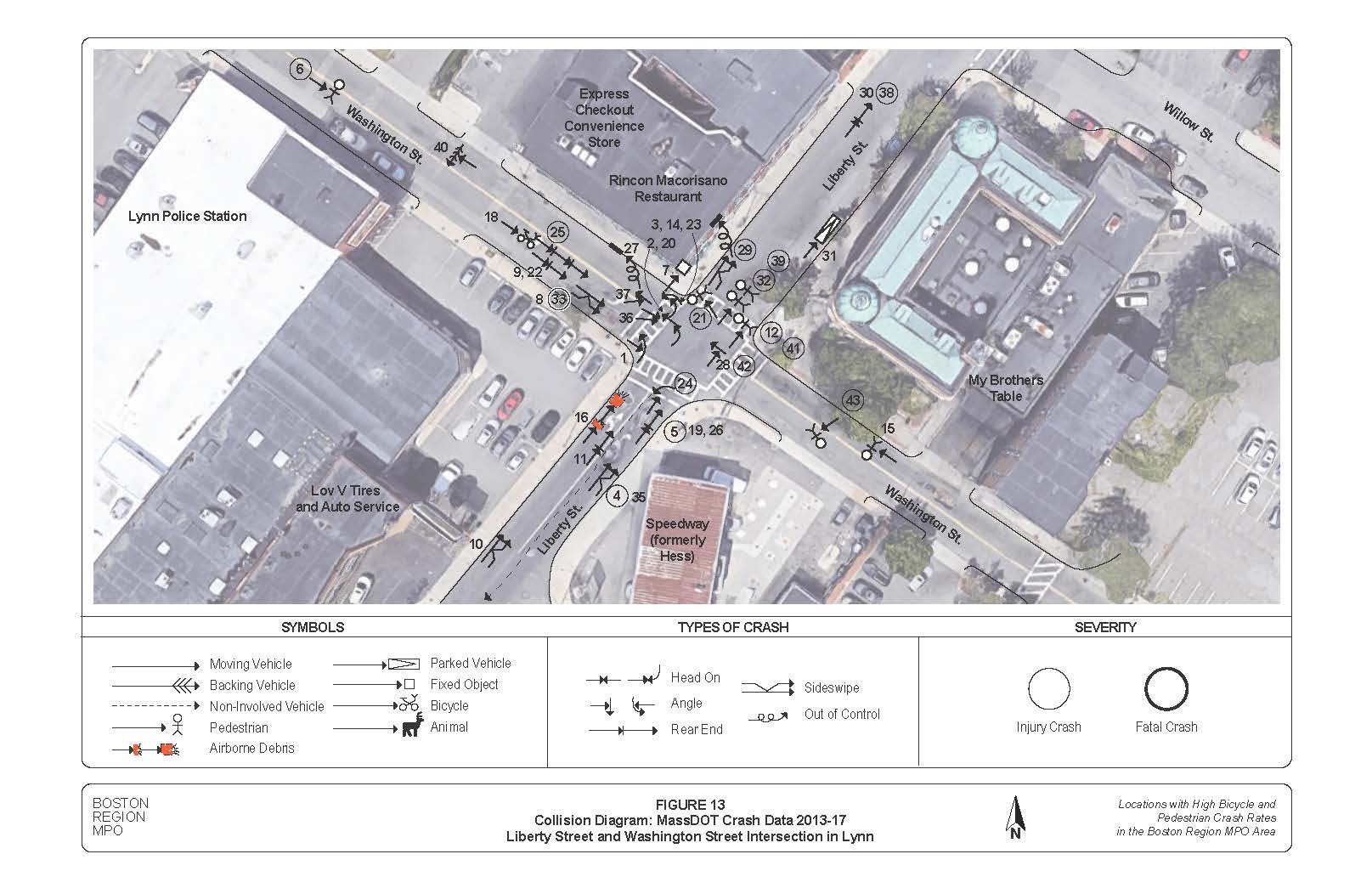
After analyzing the collision data, MPO staff concluded that crashes within the study area primarily appear to be caused by confusion and lack of visibility. Every pedestrian-involved crash for which police identified the location of the non-motorist at the time of the crash included pedestrians who were entering or crossing a marked crosswalk at the intersection. This may be attributed to two key factors:
In the one bicycle-involved crash, the bicyclist was hit while crossing between traffic on Washington Street, just west of the intersection. This behavior, while ill-advised, speaks to the lack of bicycle accommodations at the intersection of Washington Street and Liberty Street.
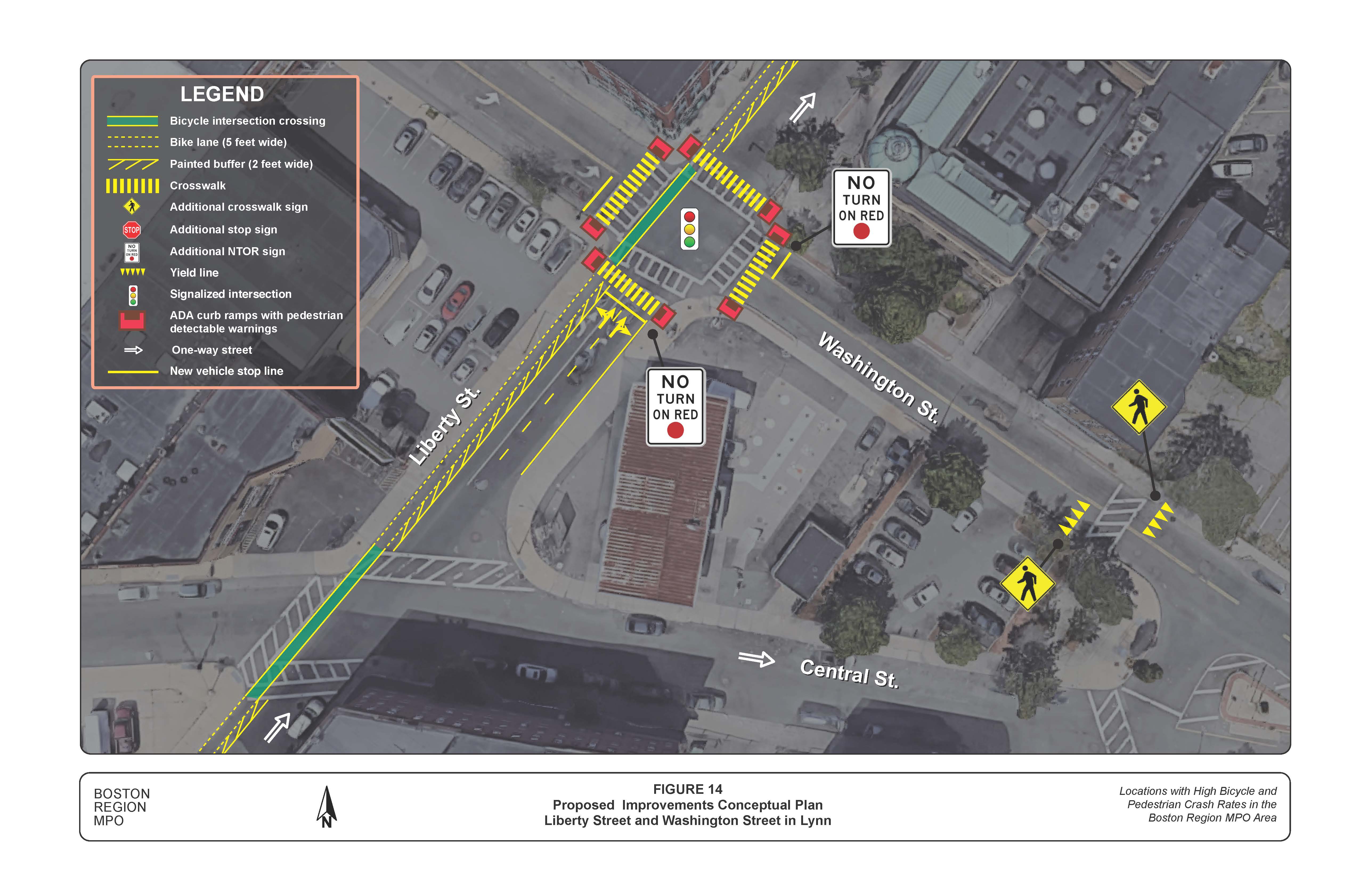
One improvement that would help all users is narrowing the curb cuts for driveways within the study area. Creating intentional, designated entrances and exits to parking lots that only allow one vehicle to enter or exit at a time will help reduce vehicle turning speeds, increase motorist awareness of all users traveling along the roadway, and improve visibility for all modes by reducing the number of vehicles along the sidewalk and curb entering or exiting at any one location.
Another improvement that would help all users at the intersection is adjusting the clearance time at the signal for vehicles and pedestrians. For through and right-turning motorists, with Lynn’s statutory speed limit of 25 miles per hour in business districts and a 60-foot crossing distance at the intersection, the total clearance time should be rounded up to 4.5 seconds.6 This clearance time comprises 3.5 seconds for the yellow clearance phase and one second for the all-red clearance. During the exclusive left-turn phase on Washington Street for motorists at the northwest intersection approach, the total clearance time should be rounded up to 5.0 seconds. This clearance time comprises 2.5 seconds for the yellow clearance phase and 2.5 seconds for the all-red clearance.
The minimum timing for the exclusive pedestrian phase at the Liberty Street and Washington Street intersection is a seven-second walk interval and a 10-second pedestrian clearance interval, for a total pedestrian phase duration of 17 seconds. This timing is based upon a pedestrian walking speed of 3.5 feet per second to cross Washington Street’s 35-foot width, and may be increased to accommodate pedestrians with slower walking speeds. Additionally, a red clearance phase with a duration between one and three seconds helps to facilitate safe pedestrian crossings.
If concurrent pedestrian signal phases are added to the intersection of Liberty Street and Washington Street, the seven-second walk phase should begin as a Leading Pedestrian Interval (LPI). The clearance time should again be 10 seconds, whether pedestrians are crossing Liberty Street or Washington Street, for a total pedestrian phase duration of 17 seconds for both concurrent pedestrian phases. Tables showing the yellow change, red clearance, and pedestrian interval calculations are included in Appendix C.
It would also be helpful for all modes at the intersection if Lynn were to install vehicle detection, which would reduce delays for both vehicles and pedestrians.
The following pedestrian improvements are recommended:
The following bicycle improvements are recommended:
Figure 14
Proposed Improvements Conceptual Plan
Liberty Street and Washington Street in Lynn
The above evaluations and recommendations support the need for improvements that would enhance bicycle and pedestrian safety and comfort at the intersection of Liberty Street and Washington Street in Lynn. The suggestions address concerns related to crashes involving people walking or bicycling. Although MPO staff were not able to analyze traffic volumes and assess travel patterns due to the COVID-19 pandemic, this memorandum presents several approaches that the City of Lynn could take to improve the quality of the pedestrian and bicyclist environment at this intersection without severely impacting other modes of travel.
As traffic patterns return to their previous levels over the coming months and years, the City of Lynn should consider documenting the motorists, bicyclists, pedestrians, and other users who regularly travel through the intersection of Liberty Street and Washington Street. Traffic counts should be used to evaluate signal timing at the intersection in order to determine the impact on traffic flow of retiming the signals to shorten pedestrian delay, perhaps by establishing a concurrent pedestrian signal phase with LPIs. Additionally, a better understanding of travel volumes by mode and turning movements would be helpful for completing applications for regional, state, and federal funding to support infrastructure improvements. If future assessments of the intersection determine that the location would benefit from geometric reconfiguration or the installation of new infrastructure for bicycle and pedestrian safety, the City of Lynn may consider applying for Transportation Improvement Program (TIP) funding through the Boston Region MPO.
Appendices
The Boston Region Metropolitan Planning Organization (MPO) operates its programs, services, and activities in compliance with federal nondiscrimination laws including Title VI of the Civil Rights Act of 1964 (Title VI), the Civil Rights Restoration Act of 1987, and related statutes and regulations. Title VI prohibits discrimination in federally assisted programs and requires that no person in the United States of America shall, on the grounds of race, color, or national origin (including limited English proficiency), be excluded from participation in, denied the benefits of, or be otherwise subjected to discrimination under any program or activity that receives federal assistance. Related federal nondiscrimination laws administered by the Federal Highway Administration, Federal Transit Administration, or both, prohibit discrimination on the basis of age, sex, and disability. The Boston Region MPO considers these protected populations in its Title VI Programs, consistent with federal interpretation and administration. In addition, the Boston Region MPO provides meaningful access to its programs, services, and activities to individuals with limited English proficiency, in compliance with U.S. Department of Transportation policy and guidance on federal Executive Order 13166.
The Boston Region MPO also complies with the Massachusetts Public Accommodation Law, M.G.L. c 272 sections 92a, 98, 98a, which prohibits making any distinction, discrimination, or restriction in admission to, or treatment in a place of public accommodation based on race, color, religious creed, national origin, sex, sexual orientation, disability, or ancestry. Likewise, the Boston Region MPO complies with the Governor's Executive Order 526, section 4, which requires that all programs, activities, and services provided, performed, licensed, chartered, funded, regulated, or contracted for by the state shall be conducted without unlawful discrimination based on race, color, age, gender, ethnicity, sexual orientation, gender identity or expression, religion, creed, ancestry, national origin, disability, veteran's status (including Vietnam-era veterans), or background.
A complaint form and additional information can be obtained by contacting the MPO or at http://www.bostonmpo.org/mpo_non_discrimination. To request this information in a different language or in an accessible format, please contact
Title VI Specialist
Boston Region MPO
10 Park Plaza, Suite 2150
Boston, MA 02116
civilrights@ctps.org
857.702.3700 (voice)
617.570.9193 (TTY)
1 An HSIP eligible cluster is one in which the total number of Equivalent Property Damage Only (EPDO) crashes is within the top five percent in the region. EPDO is a method of combining the number of crashes with the severity of crashes based on a weighted scale. Prior to 2016 the weighting factors used were as follows: a fatal crash was worth 10 points, an injury crash was worth five points, and a property-damage only crash was worth one point. Starting in 2016, the weighting factors were updated so that fatal and injury crashes are worth 21 and a property-damage only crash is worth one point. An HSIP eligible pedestrian crash cluster has an EPDO within the top five percent of all pedestrian crash clusters in the region.
2 A TAZ is the unit of geography most commonly used in conventional transportation planning models for tabulating transportation-related data. A TAZ usually consists of one or more census blocks, block groups, or census tracts. A map of the Boston region’s TAZs can be found at https://www.ctps.org/node/3122.
3 City of Lynn, “Citywide Traffic Signal Inventory: Evaluations and Recommendations Report” (Prepared by WorldTech Engineering, LLC., April 2020), 205.
4 Boston Region Metropolitan Planning Organization, “Pedestrian Level-of-Service” (Prepared by Ryan Hicks and Casey-Marie Claude, January 2017). https://www.ctps.org/ped-report-card. [Updated in 2019: Boston Region Metropolitan Planning Organization, “Pedestrian Report Card Assessment Interactive Database” (Prepared by Casey-Marie Claude, November 2019). https://www.ctps.org/data/pdf/programs/bike_ped/prca_app/2019-11-21_PRCA_Interactive_Database.pdf.]
5 Boston Region Metropolitan Planning Organization, “Development of a Scoring System for Bicycle Travel in the Boston Region” (Prepared by Casey-Marie Claude, November 2018). https://www.ctps.org/bicycle-level-of-service.
6 Massachusetts Department of Transportation, “Speed Limits in Thickly Settled or Business Districts”, 2021. https://www.mass.gov/info-details/speed-limits-in-thickly-settled-or-business-districts#municipalities-that-have-notified-massdot-of-opt-in-.
7 Otak, Inc., “Accessible Public Rights-of-Way: Planning and Designing for Alterations; Chapter 6—Curb Ramp Examples” United States Access Board, August 2007. https://www.access-board.gov/prowag/planning-and-design-for-alterations/chapter6/.
8 Association of Pedestrian and Bicycle Professionals (APBP), “Essentials of Bike Parking: Selecting and Installing Bike Parking that Works” (Prepared by Alta, September 2015). https://www.apbp.org/assets/docs/EssentialsofBikeParking_FINA.pdf.